Download

1 / 22
220 likes | 376 Vues
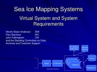
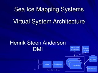
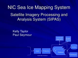
Database. Database. Database. NIC Sea Ice Mapping System. Satellite Imagery Processing and Analysis System (SIPAS). Kelly Taylor Paul Seymour . Ice Analyst Application. Browser Interface. Archive. Ingest. Production. Distribution. Henrik Steen Anderson. Database. Database.

E N D
Database Database Database NIC Sea Ice Mapping System Satellite Imagery Processing and Analysis System (SIPAS) Kelly Taylor Paul Seymour Ice Analyst Application Browser Interface Archive Ingest Production Distribution Henrik Steen Anderson
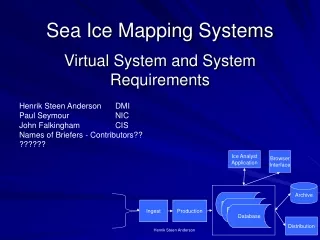
Database Database Database Introduction • System Development History • System Overview • Ingest and Ingest Production • Ancillary Data • Database • Browser Interface • Analyst Application • Chart Production • Dissemination • Archive and On-line Access • Lessons Learned • Summary Module From Virtual SIMS Architecture Ice Analyst Application Browser Interface Archive Ingest Production Distribution Henrik Steen Anderson
SIPAS System History • Paper Transitioned to Paper Replicated • GRASS, NSIPS, Terascan • Public Systems – except Terascan: from Navy METOC • Transition to ESRI Software • CARTERRA • COTS but not so COTS: ESRI and Remote View • Too much custom coding – Vendor, not applications developer of imagery analysis or GIS software • SIPAS • Remote View, ESRI and ESRI Developed Scripts • COTS with interface developed by ESRI contractor • Ongoing investment is to maintain ESRI custom scripts • RISK: Un-funded or ESRI Will Not Support Us • Mitigating Factor: There Are Lots of ESRI Programmers and the System Is Almost Entirely Standard ESRI Applications
SIPAS System Overview • Hardware • Mixture of Solaris UNIX, Linux and Windows Servers • Remote View and ESRI on PC’s with dual processors • Dual Monitors • Laptop Version • Workstations - Windows Operating System on PCs • Custom Ingest Software • Imagine and Terascan are available • Sensor Systems’ Remote View Imagery Analysis Application (COTS) • ESRI GIS Software • ARCGIS, ARCMAP, SDE, IMS • DISSEMINATION BY ESRI
ENVISAT (Under Development) SIPAS –Phase I Data Ingest
Ingest • Ice Analysts have no time to do custom ingest • What Software? – Little In-house Expertise • Imagine, Terascan, Both Or Something Else? • Requirements: Modular And Upgradable • Solution: • Custom Modules By ACT And Custom In-house • All Modules Planned to be Written By ACT Soon • Still Retain ERDAS Imagine And Terascan License • Summary: Processing the 57 Gigs Per Day of Incoming Data To a Standard Format Used By Applications Was the Single Hardest Hurdle and We Are Not Over It Yet
Ancillary Data • Met, Ocean, Ice Model Fields into SIPAS • Goal Is To Have the Data in the Same Format as the Imagery and Spatial Data • Ongoing Process • Not Fully Documented • Point of Contact hannam@natice.noaa.gov
Banks Island Canada PIPS SSM/I Satellite-Derived Ice Motion • PIPS 2.0 and 85Ghz SSM/I • Scatterometer and radiometer data complement each other in estimating ice motion • Where radiometer has difficulties, scatterometer does well and visa versa • Enables complete coverage motion maps
Weather Data into SIMS Temperature and pressure contours created in ArcInfo from FNMOC gridded data. Shapefile can be used as a layer in chart production.
Weather Data Process • Data is received from FNMOC in GRIB, cut into N and S • Hemispheres • Registered in TeraScan and Sent to ArcInfo with a header • Re-projected to Polar Stereographic • Contours produced *Automated process is command line driven
Database and Browsing • ARCGIS Geodatabase • MSSQLSERVER • Spatial Data Engine (SDE) Front End • ARCIMS To Produce Maps • RemoteView Has A Browser With Thumbnails • Draw a Box on a Map and Retrieve Available Data
Analysis Module • Sensor Systems’ Remote View • Improved By Vendor For Us • Improvement Based On Our Requirements • Still COTS – Not A Custom Package • File Formats Completely Compatible With ESRI GIS Applications
Remote View - Sensor Systems • Remote View Pro - Version 2.4 • Easily integrates with ARCView • Create, import, display and edit vector overlays (Shapefiles) • Supported formats:GeoTIFF, JPEG, ERDAS img, MrSID, RSAT, ESRI Shapefiles, DTED, etc.
SIPAS Phase II Analysis The Analysis System contains 3 Parts 1- Query of Available images based on AOI selection 2- Image Analysis 3- Attributing Create 2 shape files 1- Ice lines 2- Egg attributes
Chart Production • Currently Use ESRI GIS Package and Old Custom Avenue and ARC AML Scripts To Produce .jpegs • Legacy Method Based On Old Technology • Moving Towards New Code Based On ARC/GIS – VISUAL BASIC • Eventually; Automatic Chart Production Using ESRI Geodatabase, ARC/MAP, IMS, SDE • Deploying “Zip and Ship” of Shapes Based on International Color Codes This Year
SIPAS Phase III Dissemination The Dissemination System : 1- On Demand 2- Subscription 3- On-the-Fly Ice chart
Archive and On-line Access • Online Access • NIC: 1995-Current on WWW Site • NSIDC • Weekly or Bi-weekly “Sea” Charts • JPEG, .e00 Transfer Format, • International Color Standard • Every Two Weeks Arctic/Antarctic Hemispheric Coverage • .e00 Transfer, SIGRID 3 Archive Formats • Deep Archive • Hemispherics to NCDC in .e00 format
Sea Ice Mapping SystemLessons Learned • No Turnkey Systems • Rapid Prototyping with user participation • Custom Software by Applications Vendors • It is not easy to adopt a new system • Resistance for changes from users • Users participate in development/requirements • Must be obviously more accurate, better, faster • Find a champion • Difficulties of the learning curve • Vendor training using YOUR DATA • As little customized code as possible in a de-facto standard language
Sea Ice Mapping SystemLessons Learned • Overwhelming complexity • Modular Design • Documentation • Transformations, Conversions, Re-formats . . . • Insist on the same format for imagery analysis and spatial data files • Insist on using standards • Spatial data, imagery, graphic, archive, colors, attributes etc • Business Resumption and Portability • Ability to function as a stand alone • Laptop Version
Summary • COTS • Modular Design • Ingest, Analysis, Production, Dissemination • Same file formats throughout • User input in development • Training Using Actual Data • Availability of programming assets • Ability to upgrade with legacy support • Use Standards • Networked or Stand-alone
Questions? NOAA Satellite Operations Facility Opening September 2005