Download
1 / 35
360 likes | 508 Vues
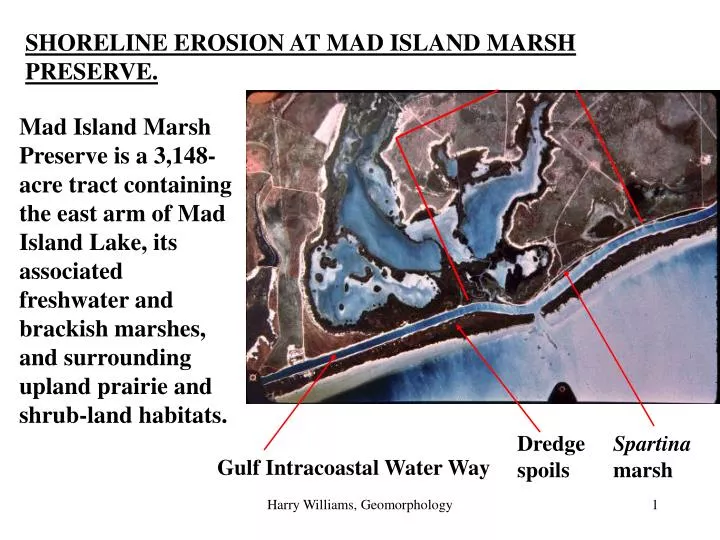
SHORELINE EROSION AT MAD ISLAND MARSH PRESERVE. Mad Island Marsh Preserve is a 3,148-acre tract containing the east arm of Mad Island Lake, its associated freshwater and brackish marshes, and surrounding upland prairie and shrub-land habitats. Dredge spoils. Spartina marsh.

E N D
SHORELINE EROSION AT MAD ISLAND MARSH PRESERVE. Mad Island Marsh Preserve is a 3,148-acre tract containing the east arm of Mad Island Lake, its associated freshwater and brackish marshes, and surrounding upland prairie and shrub-land habitats. Dredge spoils Spartina marsh Gulf Intracoastal Water Way Harry Williams, Geomorphology
The Gulf Intracoastal Water Way, constructed in 1941, cuts through the southern portion of the Preserve and is flanked to the south by man-made islands of dredge spoils. Dredgespoils GIWW - view west. Preserve Harry Williams, Geomorphology
Considerable wave erosion has occurred, and continues to occur, along the Preserve shorelines bordering the Waterway. Shorelines along the Waterway are eroded by waves generated by barge traffic. Harry Williams, Geomorphology
1992 1993 Eroded road. Harry Williams, Geomorphology
This fence was constructed several feet back from the shore one year before this photo was taken. Undercutting has caused this block of soil to fall into the GIWW. It has also destroyed the boat ramp. Harry Williams, Geomorphology
The erosion is caused by waves cutting a wave-cut notch and causing collapse and cliff formation. Harry Williams, Geomorphology
A large Spartina marsh borders the GIWW along part of the preserve shoreline. This is a valuable wildlife habitat. It is also being eroded by wave action. Harry Williams, Geomorphology
There is a sharp cliff here too (hidden by high tide in this photo). Harry Williams, Geomorphology
notch The resulting cliff edge is easily identified on air photos. Harry Williams, Geomorphology
The research study was conducted in order to provide information on the location and rate of shoreline erosion along the shores of the preserve over the last fifty years. Long-term rates of shoreline erosion were established by the analysis of sequential aerial photographs taken in 1930, 1943, 1958, 1978 and 1991. The shoreline from each photograph was transferred onto a single base map. Movement of the shoreline at selected points was measured and converted to feet (or meters) of erosion per year. 80 feet 80 feet in 20 years = 4 feet per year. 1978shoreline 1958shoreline Harry Williams, Geomorphology
1930 Harry Williams, Geomorphology
1943 Harry Williams, Geomorphology
1958 Harry Williams, Geomorphology
1978 Harry Williams, Geomorphology
1991 Harry Williams, Geomorphology
Base map. Harry Williams, Geomorphology
Measurement locations: A…Z = shoreline migration; 1..4 width of GIWW. The main preserve shoreline = A - I. Harry Williams, Geomorphology
MAD ISLAND PRESERVE, SHORELINE MIGRATION: 1943-1991 SITE 1943‑1958 1958‑1978 1978‑1991 1943‑1991 FEET FT/YR FEET FT/YR FEET FT/YR FEET FT/YR A 84 5.6 53 2.7 49 3.7 186 3.9 B 88 5.9 44 2.2 53 4.1 186 3.9 C 27 1.8 62 3.1 53 4.1 142 2.9 D 35 2.4 41 2.0 18 1.4 94 2.0 E 0 0.0 88 4.4 80 6.1 168 3.5 F 0 0.0 53 2.7 62 4.8 115 2.4 G 0 0.0 35 1.8 71 5.4 106 2.2 H 0 0.0 31 1.5 71 5.4 102 2.1 I 0 0.0 44 2.2 27 2.0 71 1.5 J 0 0.0 35 1.8 0 0.0 35 0.7 For the main preserve shoreline, erosion rates for the most recent period (1978-1991) vary from 0 to 6.1 feet per year. WIDTH OF WATERWAY (feet) RATIO: SITE 1943 1958 1978 1991 1991/1943 1 150 230 425 469 313% 2 212 336 504 531 250% 3 212 292 513 593 280% 4 195 354 531 558 286% The width of the water way increased by an average of 282%. Harry Williams, Geomorphology
An important finding of the study is that severe erosion is occurring near the entrance to Mad Island Bayou. Bayou entrance Harry Williams, Geomorphology
1943 1991 Harry Williams, Geomorphology
1992 1993 1994 Views west from the end of the peninsula. Harry Williams, Geomorphology
GIWW Bayou The large bend in the bayou was about 24 feet from the GIWW in 1994. Breaching of the peninsula at this point would abruptly shorten Mad Island Bayou by several hundred meters and probably increase salt water intrusion into Mad Island Lake. Harry Williams, Geomorphology
Partly as a result of this study, the Nature Conservancy of Texas built concrete erosion barriers along this part of the preserve shoreline in 1996 - so far they appear to be working - there has been no more erosion along this part of the shoreline. Harry Williams, Geomorphology
UPDATE: In 2005, a grad student (Webster Mangham) did a Masters thesis on erosion at MIMP between 1995 and 2005. He used GPS, DOQQs and GIS. Harry Williams, Geomorphology
The concrete mat still looks pretty good (in places) after 9 years. Harry Williams, Geomorphology
BUT – in other places it has clearly failed – the soil has been washed out from under it and it has collapsed. Harry Williams, Geomorphology
2008 Harry Williams, Geomorphology
1991 Harry Williams, Geomorphology
2013 Harry Williams, Geomorphology