Download
1 / 8
80 likes | 83 Vues
Hello everyone from the 2009 Islander Rendezvous,

E N D
Hello everyone from the 2009 Islander Rendezvous, On behalf of my wife Marion and myself, the token Canucks, this is a Big Thank You for all the hospitality we received on the September 12th and 13th Rendezvous weekend. What a wonderful bunch of enthusiasts you have. And I see that you are spending our outrageous dues ($15.00) wisely! Nice city too, by the way. Attached is a teaser for anyone contemplating some northern cruising – just a sampler of good areas and an overview of Vancouver Island. Our province is British Columbia, with the charming capitol city of Victoria is on the southern end of Vancouver Island, and it is a beautiful cruising destination. Ladysmith where we live is on the east coast of Vancouver Island, right on the 49th parallel. On the same Gulf Islands chartlet, there is a harbour (Canadian spelling!) between Thetis and Kuper Islands called Telegraph Harbour, the site of 3 of the 4 Canadian Rendezvous. Across the pond, also known as the Strait of Georgia, served by 3 main ferry routes, is the large city of Vancouver, or “Big Smoke” as some of us call it. Sailing is generally better on the Strait than in the Gulf Islands, and we have had some long, 8 knot beam reaches across the Strait over the years, but summer typically has light winds in this area except when a low pressure system is approaching. Sailboats here need a decent engine. The normal wind is SW heralding a low, and NW heralding sunny weather. The westerlies as they are called sometimes can be very strong in the Strait of Juan de Fuca to the south of Vancouver Island, and also in Johnstone Strait on the inside northerly parts of the Island. Georgia Strait can get good strong winds anytime. Late July, all of August, and early September tend to be the warmest and driest time; however for the west coast of the Island, earlier in the year has less fog. The Gulf Island are probably the most popular cruising destination, followed by Desolation Sound. Princess Louisa inlet is spectacular for mountains and waterfalls, particularly in June while the snow melt is happening. And the cruise can be done easily in a week. False Creek in Vancouver is worth seeing; there are a number of marinas, and anchoring is possible with a free city of Vancouver permit (this keeps out the riff-raff). Beyond the friendly “inside” waters are the wilder and beautiful areas on the west coast and at the northern end of Vancouver Island. Ports of entry for boaters are Victoria, Nanaimo, Sidney, and Bedwell Harbour. There are a lot of charter companies which I won’t try to list, but a couple of good references are the “48 North” magazine out of Seattle (similar in concept to your own “Latitude 38”, and “Pacific Yachting” published in Vancouver. Paper charts from the Canadian Hydrographic Service of course are necessary for backing up the electronic navigational aids that most boaters seem to have now (and which can go Phhtt! when they feel like it). For the passes, and for anchoring etc, its also a good idea to have a tide book along. The tides can range from a maximum of 12 feet or so in the Gulf Islands to a maximum of 16 feet further north. The currents in the passes can be up to 8 knots in the Gulf Island passes, but up to 16 knots up north!!!. Get a book, go through at slack, no problem. We hope to see you guys up here sometime. Feel free to email us at jmrodall@shaw.ca . Good Sailing! John and Marion Rodall I36 Holole’a
Broughton Archipelago Also called Blackfish Sound Desolation Sound Princess Louisa Inlet 50 Deg N. Lat. Sunshine Coast 60 Nautical Miles USA/Can Border 49 Deg N. Lat Canadian Gulf Islands Barkley Sound American San Juan Islands
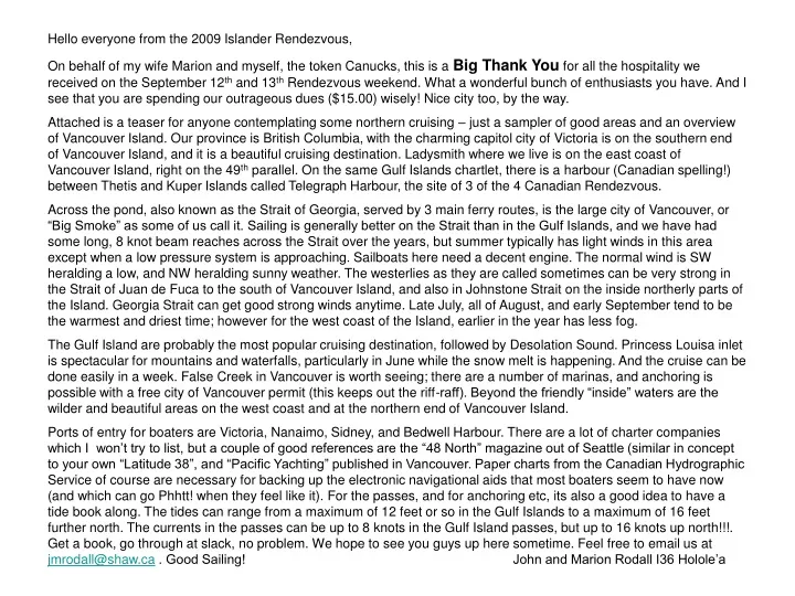
Sample Gulf Islands Chart – our town of Ladysmith is middle left. The Gulf Islands are arguably the most popular cruising area of British Columbia. The navigation is relatively easy, there are a number of small and large towns to dock at, and lots of harbours to anchor in. The tidal passes to the Strait of Georgia do need some attention; on a large tide they can exceed 8 knots, so wait for slack. The Canadian Rendezvous at Thetis Island is approximately center. Note that Canadian Charts are Metric for depths
Sample San Juan Islands to the right, International Boundary Center, Part of Vancouver Island Left, and a few Ebb Current Arrows
Sample Barkley Sound – see the Islander 36 website 2009 - Vermeer’s Barkley Sound Cruise This area is definitely West Coast, and it is a bit of a grind to get there. There is lots of weather both good and bad, fog sometimes, lots of rocks, all charted, but few marked. When the sun comes out the scenery is marvellous! When the weather turns nasty, there are lots of places to hide. It is mostly anchoring here – lots of hidey-holes if you are brave). You need good charts and some decent navigational skills. There are only a few places to provision – Bamfield on the south side and Ucluelet on the north-west side.
Very Popular Desolation Sound with great scenery and good swimming. Mostly anchoring here, the main provisioning place is Refuge Cove, approximately in the center of the chartlet. See the Islander 36 website 2005 - Vermeer’s Desolation Sound Cruise.
The long trek to Princess Louisa Inlet (upper right) – See the Islander 36 website 2005 Rodall’s Chatterbox Falls Cruise Note Red Current Arrows at bottom - Skookumchuk Narrows – wild on a big tide –no you don’t need to go through here, but it’s a nice 1 hour walk from the dock at Egmont. Crazy whitewater kayakers play in the standing waves. There is also a significant tidal current at the entrance to Princess Louisa – plan ahead for slack!
Sample of the northern reaches of the Vancouver Island section of the Inside Passage – Beyond Desolation Sound the whole world changes to wilder and remote. Commonly known as the Broughton Archipelago. Lots of passes that need serious attention to the Tide and Current Tables (red arrows show an ebb current) and lots of rocks – all charted but few marked. Beautiful area, not too many facilities, but there are usually Killer Whales somewhere. With good charts and good navigation it is very worthwhile. There are a few remote facilities, and the main town is Port McNeil. This is a good area to pack extra water and fuel. The Inside Passage is the famous and well traveled “relatively sheltered” waterway between Puget Sound and Alaska. It is heavily used by commercial shipping and Cruise ships. Keep your eyes open in the narrower places.