Download

1 / 36
360 likes | 669 Vues
In the following presentation you will find information about the five geographic regions of Virginia . Read and enjoy!. Try the multiple choice questions. Refer to your Virginia History SOL booklets for help!. The Five Geographic Regions of Virginia. Coastal Plain (Tidewater ).

E N D
In the following presentation you will find information about the five geographic regions of Virginia. Read and enjoy! Try the multiple choice questions. Refer to your Virginia History SOL booklets for help!
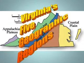
The Five Geographic Regionsof Virginia Coastal Plain (Tidewater) Blue Ridge Mountains Piedmont Valley and Ridge Appalachian Plateau
Distinctive Characteristicsof each region • Coastal Plain(Tidewater) low, flat land sandy soil • located near the Atlantic Ocean and the Chesapeake Bay • located east of the Fall Line • Our peninsula, the Northern Neck, is located in this region.
The Peninsulas and their bordering bodies of water: • Northern Neck : bordered by the Potomac and the Rappahannock rivers • Middle Peninsula :bordered by the Rappahannock and the York rivers • The Peninsula :bordered by the York and the James rivers • The Eastern Shore Peninsula : bordered by the Chesapeake Bay and the Atlantic Ocean
Piedmont • The word Piedmont means (land at the foot of the mountains) • rolling hills (Look at the picture on page 61 in your textbook) • located west of the Fall Line • This is Virginia’s largest region. It is also called the Plateau. ( A plateau is a large, raised ,level piece of land) • Our state capital, Richmond,is located here.
The Fall Line • This is part of the Piedmont region.It has many waterfalls and rapids.The waterfalls prevented further travel on the rivers during Colonial Virginia and this cause towns to spring up. The towns later became cities like Richmond, Fredericksburg,Alexandria, Petersburg,and later Emporia.They are all Fall Line cities because they grew up along major Virginia rivers.
Fall Line cities and the Rivers they developed along Alexandria was developed along the Potomac River. Fredericksburg was developed along the Rappahannock River. Richmond was developed along the James River. Petersburg was developed along the Appomattox River. Emporia was developed along the Meherrin River.
Alexandria Potomac River Rappahannock River James River Petersburg Emporia
Let’s Review Look at the previous slide if you need help at any time. A. On what river was the Fall Line city of Alexandria developed? That’s right! Potomac! B. On what river was our state capital, Richmond, developed? Well, James River, of course! C. Name the Fall Line city that’s located directly south of Petersburg. Did you say Emporia? Good! D. On what river did this city develop ? Meherrin River!
Let’s imagine that you are one of the early settlers traveling on the Potomac River. You’re now approaching a sudden drop in the way that your ship was moving. What do you think could have happened? Go to the next slide and look closely! Click the back-arrow to come back to this slide! Now. Let’s go back. Did you see how difficult it would be to continue your journey. You would actually have to get out of your boat and barter, or trade your goods in order to walk around the falls and then get back in your boat once it has gotten around the falls.
Look again! Would it be possible for a boat to travel with ease on water like this? No, I didn’t think that you would like it!
Blue Ridge Mountains • Old, rounded mountains(stretching from Pennsylvania to Georgia) • part of the Appalachian Mountain system (This mountain system stretches from Canada to Alabama. • ridge = a line of hills or mountains • located between the Piedmont and Valley and Ridge regions • Source of many rivers
Valley and Ridge • Includes the Great Valley of Virginia and other valleys separated by ridges (the Great Valley lies between the Allegheny and the Blue Ridge Mountains) • It is ruggeddue to many high and rocky peaks. • The Blue Ridge Mountains and the Valley and Ridge Regions are part of the Appalachian Mountain system. • Located west of the Blue Ridge Mountains
Appalachian Plateau • Plateau : an area of elevated land that is flat on top • located in Southwest Virginia • bordered by the states of Tennessee and Kentucky
Virginia’s Products and Industries Shipbuilding, tourism, federal military installations Coastal Plain (Tidewater) Seafood Tobacco products, information technology Technology, federal and state government,farming,textiles Piedmont Blue Ridge Mountains Apples Recreation Farming Valley and Ridge Poultry, apples Coal mining Coal Appalachian Plateau
Facts about some Virginia cities: Norfolk : home to the largest Naval Base in Virginia There are a lot of people working in military jobs here. Newport News : home to the largest shipbuilding yards in the United States Virginia Beach : well known resort city This city helps Virginia’s tourism industry. This is Virginia’s most populated independent city.
Federal and State Government The state government is led by the governor. Our former governor of the state of Virginia is James Gilmore. He stayed in Richmond, our state capital, in the house known as the Governor’s Mansion.
Virginia’s First African - American Governor Lawrence Douglas Wilder was the first African- Ameri- can to be governor of Virginia. He was also the first African - American governor in the U.S. since Reconstruction.
Which of these isn’t one of Virginia’s five geographic regions? A. Coastal Plain (Tidewater) B. Piedmont C. Valley & Ridge D. Rocky Mountains E. Appalachian Plateau
Which region is farthest west? N A. Appalachian Plateau B. Atlantic Ocean C. Coastal Plain (Tidewater) D. Eastern Shore W E S
Which region is directly west of the Fall Line? A. Appalachian Plateau B. Piedmont C. Valley & Ridge D. Coastal Plain (Tidewater)
In which region is Richmond located? A. Coastal Plain (Tidewater) B. Piedmont C. Eastern Shore Peninsula D. Northern Neck Peninsula
Which of Virginia’s regions isthe largest? A. Piedmont B. Coastal Plain (Tidewater) C. Appalachian Plateau D. Blue Ridge Mountain
Which rivers border the NorthernNeck Peninsula? A. Pamunkey River, James River B. Chesapeake Bay, Atlantic Ocean C. Rappahannock River, Potomac River D. James River, York River
Which two geographic regions are separated by the Fall Line? A. Blue Ridge Mountains, Piedmont B.Valley & Ridge, Appalachian Plateau C.Coastal Plain (Tidewater), Piedmont D.Valley & Ridge,Blue Ridge Mt.
(Tidewater) In which of Virginia’s regions would you live? A. Valley & Ridge B. Piedmont C. Coastal Plain (Tidewater) D. Appalachian Plateau
Which of Virginia’s regions is closest to the state of Kentucky? A. Blue Ridge Mountains B. Appalachian Plateau C. Valley & Ridge D. Piedmont
Which peninsula is bordered by the Atlantic Ocean and the Chesapeake Bay? A. Piedmont B. Eastern Shore Peninsula C. Valley & Ridge D. Northern Neck Peninsula
Which of Virginia’s geographic regions is known for having rolling hills as one of its characteristics? A.Coastal Plain (Tidewater) B. Shenandoah Valley C. Piedmont D. Valley and Ridge
Which of the following would’ve contributed a lot to the development of early Fall Line towns? A. pathways B. rapids and valleys C. highways D. waterfalls and rapids
How were the rivers useful to the early colonists of Colonial Virginia? A. They provided a place for gathering rocks and jewels. B. They provided pathways for exploration and were a source of food to all who wanted some. C. They were a good source of food for all animals. D. They provided pathways for exploration and sail.
Which of the following is a major characteristic of a plateau? A.hills and valleys B. ridges and valleys C. elevated land that is flat on top D. mountainous land
C h e s a p e a k e B a y Northern Neck Peninsula Potomac River Eastern Shore Middle Peninsula Rappahannock River The Peninsula Atlantic Ocean The Southside