Download
1 / 28
280 likes | 426 Vues
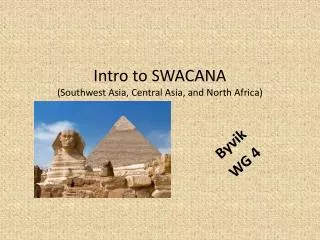
North African, central Asia , and Southwest Asian Culture, Geography, Climate and History. By: Shayne Gardner Teresa Murphy Claudia Beinhauer. ANCIENT EGYPT. ANCIENT EGYPT. Around 5000 BC, farm villages began to develop along the Nile River in North Africa.

E N D
North African, central Asia, and Southwest Asian Culture, Geography, Climate and History By: Shayne Gardner Teresa Murphy Claudia Beinhauer
ANCIENT EGYPT • Around 5000 BC, farm villages began to develop along the Nile River in North Africa. • For centuries the Egyptians farmed and were protected by desert, the seas and the Nile. • In social society, rulers, priests, and nobles came first, then business and crafts people, and at the bottom –most Egyptians- farmers and unskilled workers. • Religion was at the center of Egyptians society. Sometime around 3100 BC, Egypt became a united kingdom under a single ruler. Egyptians where ruled by pharaohs.
Worshiping in Egyptian Society Egyptians worshiped many gods and goddesses. God of NameAppearance Sun Ra head of falcon and sun disk Music Hathor horns of cow and sun disk Destruction Sekhmet head of lion Sky Nut blue with golden stars Earth Geb color of plants and Nile mud Dead Osiris dressed in white with crook and flail Desert Seth animal head with long curved snout Pharaoh Horus head of hawk and crown of Egypt Magic Isis throne on head or holding baby Wisdom Thoth head of ibis Embalming Anubis head of jackal Justice Ma'at feather in her hair Creation Amun crowned with feathers Cats Bastet head of cat
PHOROAHS EGYPTIANS WHERE RULED BY PHOROAHS • Egyptians were ruled by pharaohs • They believed that pharaohs were gods as well as rulers • Large tombs, pyramids, were the tombs of pharaohs
KING TUT • King Tut is probably the most known Egyptian king • He was very young when crowned king • King Tut died at a very young age, and is still thought as the greatest Egyptian king there ever was.
KING TUT This is a picture of King Tut’s coffin
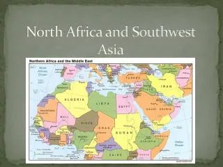
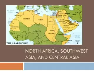
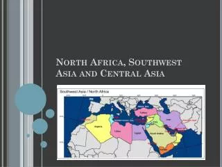
Countries In North Africa and Southwest Asia • Morocco • Algeria • Tunisia • Libya • Egypt • Israel • Lebanon • Jordan • Syria • Saudi Arabia • Yemen • Oman • Kuwait • United Arab Emirates • Iran • Turkey • Iraq • Georgia • Armenia • Azerbaijan • Afghanistan • Turkmenistan • Tajikistan • Uzbekistan • Kazakhstan • Kyrgyzstan
Geography • On north Africa’s eastern edge there is a man made waterway called the Suez Canal • Ships use this canal to pass from the Mediterranean sea to the Red Sea
Languages Spoken in North Africa and Southwestern Asia • Dari • Pashto • Arabic • Armenian • Azerbaijan • Georgian • Persian • Hebrew • Kazakh • Russian • Kyrgyz • French • Tajik • Turkish • Turkmen • Uzbek
NORTH AFRICA This is a Map of Northern Africa
SOUTHWEST ASIA This is a map of Southwestern Asia
Major Physical Features • Sahara Desert • Atlas Mountains • Ahaggar Mountains • Akhar Mountains • Quattara Depression • Anatolian Peninsula • The Steppes • Plateau of Iran • Zagros Mountains • Hindukush Mountains • Khyber Pass • Sinai Peninsula • Aswan High Dam • Suez Canal • Lake Balkash • Syrdarya River • Caspian Sea • Nile River • Red Sea • Gulf of Oman • Persian Gulf • Mediterranean Sea • Ertis River • Sea of Marmara • Aral Sea Landforms Bodies of water
History • Two of the world’s earliest civilizations arose 5000 years ago in the southwest • Three of the world’s major religions began in Southwest Asia • Independent states arose during the 1900s • The Arab empire made contributions in mathematics, astronomy,, medicine, and the arts
history • By the end of World War I, European powers gained control of much of the region. • Oil reserves brought wealth to countries such as Saudi Arabia, Iraq, and Iran. • Political unrest and conflict have troubled the region since World War II.
General Culture • The Islam and the Arabic languages are dominant • In Saudi Arabia women can’t vote or drive without being accompanied by a male relative • The people greatly value family life • Traditionally men have the dominant role in the family
Religions of Africa and Asia • The three major religions are Judaism, Christianity, and Islam • Religion is very important to the people • Israel is mainly Jewish • Armenia and Georgia are largely Christian • Religion provided inspiration for artists and architects
Culture • Water is scarce so most people try to live along sea coasts and rivers • More than 50% of the people live in urban areas as apposed to rural areas • High birthrate has led to rapid growth in the regions population
Climate • The Sahara is a dry region • The highest temperature ever reached in the Sahara was 136f • In central Asia there is a rain shadow created by high peaks of mountains • Other climate zones include the subtropical and the Mediterranean zones
Overall climate • Large areas of desert greatly affect life in this region. • Most people live in steppe areas and coastal plains that receive adequate rainfall. • The region’s generally dry climate and a growing population have led to a water shortage. • One approach to managing water use is desalinization. Desalinization is costly, however so poor countries are not able to use this process and will continue to face water shortages.
North Africa’s climate • The Sahara, the world’s largest desert, covers almost all of North Africa. • North Africa is primarily desert or arid, or to be without moisture. • North Africa is highly vulnerable to climate change.
Southwest Asia's climate • In South Asia there exists vast expanses of forests and fertile valleys. • The winds are dry and dusty, with occasional gusts up to 80 kilometers or 50 miles per hour. • These winds often kick up violent sand and dust storms that can carry sand a few thousand meters high, and can close airports for short periods of time.
Central Asia's climate • Since Central Asia is not buffered by a large body of water, temperature fluctuations are more severe. • Winds from the oceans are cut off by mountain chains which surround the interior, because of this, the climate of Central Asia is one of extremes. • Climate change can increase further water scarcity in the region and the problems of the Aral Sea.
SOURCES • http://gwydir.demon.co.uk/jo/egypt/index.htm • http://centralasia.foreignpolicyblogs.com/2007/04/05/central-asia-climate-change-overview/ • http://www.chinatownconnection.com/asia-climate.htm • http://www.developmentandtransition.net/index.cfm?module=ActiveWeb&page=WebPage&DocumentID=683