Download
1 / 49
490 likes | 627 Vues
Zone V. BFE 11.3. SFHA Zone V with a Community Issued BFE, Residential Structure on Posts. Sandy Beach. 15610 Seaward Avenue. Floodville CA 96580. Lot 45 of Riverview Subdivision No. 10/APN # 080-132-018. Residential. 36 º 46’ 45.77â€N. X. 119 º 46’ 07.07†W.

E N D
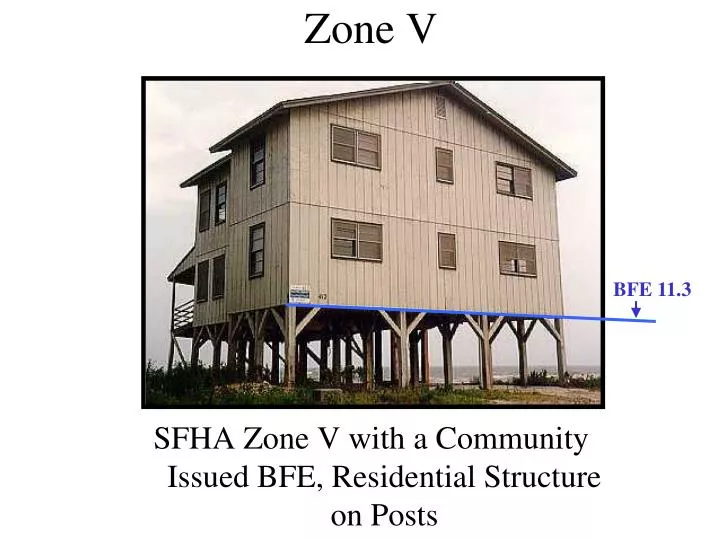
Zone V BFE 11.3 SFHA Zone V with a Community Issued BFE, Residential Structure on Posts
Sandy Beach 15610 Seaward Avenue Floodville CA 96580 Lot 45 of Riverview Subdivision No. 10/APN # 080-132-018 Residential 36º 46’ 45.77”N X 119º 46’ 07.07” W
1A) Slab on Grade 1B) Raised Slab on Grade or Stem-Wall 2) Basement Foundation 3) Split Level Slab on grade 4) Basement-Split Level Foundation 5) Piers, Post, Pile, Columns, or Shear Wall Foundations With No Obstructions 6) Post, Pile, Piers, Columns, or Shear Wall Foundation With Enclosure 7) Full-Story Foundation Walls 8) Crawl Space Foundation 9) Sub-grade Crawlspace 9 Building Foundation Diagrams
C2.b NEXT HIGHER FLOOR C2.a ELEVATED FLOOR GRADE (For V zones only) (determined by existing grade) C2.f-g C2.c DIAGRAM 5 All buildings elevated on piers, posts, columns, or parallel shear walls. No obstructions below the elevated floor. Distinguishing Feature – For all zones, the area below the elevated floor is open, with no obstruction to flow of flood waters (open lattice work and/or readily removable insect screening is permissible).
Sandy Beach 15610 Seaward Avenue Floodville CA 96580 Lot 45 of Riverview Subdivision No. 10/APN # 080-132-018 Residential 34º 25’ 48. 07” N 119º 49’ 48. 77”W X 5 N/A N/A N/A N/A N/A N/A X X
SECTION B FLOOD INSURANCE RATE MAP (FIRM) INFORMATION B2. COUNTY NAME B3. STATE B1. NFIP COMMUNITY NAME & COMMUNITY NUMBER Floodville 060001 B6. FIRM INDEX DATE B4. MAP AND PANEL NUMBER B5. SUFFIX B7. FIRM PANEL EFFECTIVE/REVISED DATE B8. FLOOD ZONE(S) B9. BFE(S) (Zone AO, use depth) B10. Indicate the source of the Base Flood Elevation (BFE) data or base flood depth entered in B9. |_|FIS Profile |_|FIRM |_|Community Determined |_| Other (Describe): B11. Indicate the elevation datum used for the BFE in B9: |_|NGVD 29 |_|NAVD 88 |_| Other (Describe): B12. Is the building located in a Coastal Barrier Resources System (CBRS) area or Otherwise Protected Area (OPA)? |_| Yes |_| NO Designation Date:
NATIONAL FLOOD INSURANCE PROGRAM FIRM FLOOD INSURANCE RATE MAP CITY OF FLOODVILLE, CALIFORNIA PANEL 0001 OF 0004 B1. Community Name Note: B1, B2 and B3 should be filled in with the actual community, community number & state where the building is located at the time the EC is filled out. This may not necessarily match the map information. COMMUNITY-PANEL NUMBERS 060001 0004 E MAP REVISED July 9, 1997 Federal Emergency Management Agency B1. Community Number
SECTION B FLOOD INSURANCE RATE MAP (FIRM) INFORMATION B2. COUNTY NAME B3. STATE B1. NFIP COMMUNITY NAME & COMMUNITY NUMBER Floodville 060001 River County CA B6. FIRM INDEX DATE B4. MAP AND PANEL NUMBER B5. SUFFIX B7. FIRM PANEL EFFECTIVE/REVISED DATE B8. FLOOD ZONE(S) B9. BFE(S) (Zone AO, use depth) 060001 0004 B10. Indicate the source of the Base Flood Elevation (BFE) data or base flood depth entered in B9. |_|FIS Profile |_|FIRM |_|Community Determined |_| Other (Describe): B11. Indicate the elevation datum used for the BFE in B9: |_|NGVD 29 |_|NAVD 88 |_| Other (Describe): B12. Is the building located in a Coastal Barrier Resources System (CBRS) area or Otherwise Protected Area (OPA)? |_| Yes |_| NO Designation Date:
NATIONAL FLOOD INSURANCE PROGRAM FIRM FLOOD INSURANCE RATE MAP CITY OF FLOODVILLE, CALIFORNIA PANEL 0001 OF 0004 B4. Panel Number COMMUNITY-PANEL NUMBERS 060001 0004 E MAP REVISED July 9, 1997 Federal Emergency Management Agency
SECTION B FLOOD INSURANCE RATE MAP (FIRM) INFORMATION B2. COUNTY NAME B3. STATE B1. NFIP COMMUNITY NAME & COMMUNITY NUMBER Floodville 060001 River County CA B6. FIRM INDEX DATE B4. MAP AND PANEL NUMBER B5. SUFFIX B7. FIRM PANEL EFFECTIVE/REVISED DATE B8. FLOOD ZONE(S) B9. BFE(S) (Zone AO, use depth) 060001 0004 E B10. Indicate the source of the Base Flood Elevation (BFE) data or base flood depth entered in B9. |_|FIS Profile |_|FIRM |_|Community Determined |_| Other (Describe): B11. Indicate the elevation datum used for the BFE in B9: |_|NGVD 29 |_|NAVD 88 |_| Other (Describe): B12. Is the building located in a Coastal Barrier Resources System (CBRS) area or Otherwise Protected Area (OPA)? |_| Yes |_| NO Designation Date:
NATIONAL FLOOD INSURANCE PROGRAM FIRM FLOOD INSURANCE RATE MAP CITY OF FLOODVILLE, CALIFORNIA PANEL 0001 OF 0004 COMMUNITY-PANEL NUMBERS 060001 0004 E MAP REVISED July 9, 1997 Federal Emergency Management Agency B5. Suffix
SECTION B FLOOD INSURANCE RATE MAP (FIRM) INFORMATION B2. COUNTY NAME B3. STATE B1. NFIP COMMUNITY NAME & COMMUNITY NUMBER Floodville 060001 River County CA B6. FIRM INDEX DATE B4. MAP AND PANEL NUMBER B5. SUFFIX B7. FIRM PANEL EFFECTIVE/REVISED DATE B8. FLOOD ZONE(S) B9. BFE(S) (Zone AO, use depth) April 23, 1999 060001 0004 E B10. Indicate the source of the Base Flood Elevation (BFE) data or base flood depth entered in B9. |_|FIS Profile |_|FIRM |_|Community Determined |_| Other (Describe): B11. Indicate the elevation datum used for the BFE in B9: |_|NGVD 29 |_|NAVD 88 |_| Other (Describe): B12. Is the building located in a Coastal Barrier Resources System (CBRS) area or Otherwise Protected Area (OPA)? |_| Yes |_| NO Designation Date:
FIRM FLOOD INSURANCE RATE MAP CITY OF FLOODVILLE, CALIFORNIA MAP INDEX COMMUNITY-PANEL NUMBERS 060001 0001-0004 MAP REVISED April 23, 1999 Federal Emergency Management Agency B6. FIRM Index Date
SECTION B FLOOD INSURANCE RATE MAP (FIRM) INFORMATION B2. COUNTY NAME B3. STATE B1. NFIP COMMUNITY NAME & COMMUNITY NUMBER Floodville 060001 River County CA B6. FIRM INDEX DATE B4. MAP AND PANEL NUMBER B5. SUFFIX B7. FIRM PANEL EFFECTIVE/REVISED DATE B8. FLOOD ZONE(S) B9. BFE(S) (Zone AO, use depth) July 9, 1997 April 23, 1999 060001 0004 E B10. Indicate the source of the Base Flood Elevation (BFE) data or base flood depth entered in B9. |_|FIS Profile |_|FIRM |_|Community Determined |_| Other (Describe): B11. Indicate the elevation datum used for the BFE in B9: |_|NGVD 29 |_|NAVD 88 |_| Other (Describe): B12. Is the building located in a Coastal Barrier Resources System (CBRS) area or Otherwise Protected Area (OPA)? |_| Yes |_| NO Designation Date:
NATIONAL FLOOD INSURANCE PROGRAM FIRM FLOOD INSURANCE RATE MAP CITY OF FLOODVILLE, CALIFORNIA PANEL 0001 OF 0004 COMMUNITY-PANEL NUMBERS 060001 0004 E MAP REVISED July 9, 1997 Federal Emergency Management Agency B7. Revised Date
SECTION B FLOOD INSURANCE RATE MAP (FIRM) INFORMATION B2. COUNTY NAME B3. STATE B1. NFIP COMMUNITY NAME & COMMUNITY NUMBER Floodville 060001 River County CA B6. FIRM INDEX DATE B4. MAP AND PANEL NUMBER B5. SUFFIX B7. FIRM PANEL EFFECTIVE/REVISED DATE B8. FLOOD ZONE(S) B9. BFE(S) (Zone AO, use depth) July 9, 1997 11.3 V 060001 0004 E April 23, 1999 B10. Indicate the source of the Base Flood Elevation (BFE) data or base flood depth entered in B9. See Comments |_|FIS Profile |_|FIRM |_|Community Determined |_| Other (Describe): X B11. Indicate the elevation datum used for the BFE in B9: |_|NGVD 29 |_|NAVD 88 |_| Other (Describe): B12. Is the building located in a Coastal Barrier Resources System (CBRS) area or Otherwise Protected Area (OPA)? |_| Yes |_| NO Designation Date:
For Insurance Company Use: IMPORTANT: In these spaces, copy the corresponding information from Section A. BUILDING STREET ADDRESS (Including Apt., Unit, Suite and/or Bldg. No.) OR P.O. ROUTE AND BOX No.) Policy Number 15610 Seaward Avenue Company NAIC Number CITY STATE ZIP CODE Floodville CA 96580 SECTION D - SURVEYOR, ENGINEER, OR ARCHITECT CERTIFICATION (CONTINUED) Copy both sides of this Elevation Certificate for (1) community official, (2) insurance agent/ company, and (3) building owner. COMMENTS B10.) The base flood elevation was determined from the Core of Engineer’s study entitled “Coastal Flooding Near Floodville” dated March 1996. This report is filed at the Floodville Building Department. |_| Check here if attachments
SECTION B FLOOD INSURANCE RATE MAP (FIRM) INFORMATION B2. COUNTY NAME B3. STATE B1. NFIP COMMUNITY NAME & COMMUNITY NUMBER Floodville 060001 River County CA B6. FIRM INDEX DATE B4. MAP AND PANEL NUMBER B5. SUFFIX B7. FIRM PANEL EFFECTIVE/REVISED DATE B8. FLOOD ZONE(S) B9. BFE(S) (Zone AO, use depth) July 9, 1997 11.3 V 060001 0004 E April 23, 1999 B10. Indicate the source of the Base Flood Elevation (BFE) data or base flood depth entered in B9. See Comments |_|FIS Profile |_|FIRM |_|Community Determined |_| Other (Describe): X B11. Indicate the elevation datum used for the BFE in B9: |_|NGVD 29 |_|NAVD 88 X |_| Other (Describe): B12. Is the building located in a Coastal Barrier Resources System (CBRS) area or Otherwise Protected Area (OPA)? |_| Yes |_| NO X N/A Designation Date:
Finished Construction Select “Finished Construction” only when all machinery and/or equipment such as furnaces, hot water heaters, heat pumps, air conditioners, and elevators and their associated equipment have been installed and the grading around the building is completed.
X CM880 NAVD 88 See Comments in Section D
For Insurance Company Use: IMPORTANT: In these spaces, copy the corresponding information from Section A. BUILDING STREET ADDRESS (Including Apt., Unit, Suite and/or Bldg. No.) OR P.O. ROUTE AND BOX No.) Policy Number 15610 Seaward Avenue Company NAIC Number CITY STATE ZIP CODE Floodville CA 96580 SECTION D - SURVEYOR, ENGINEER, OR ARCHITECT CERTIFICATION (CONTINUED) Copy both sides of this Elevation Certificate for (1) community official, (2) insurance agent/ company, and (3) building owner. COMMENTS B10.) The base flood elevation was determined from the Core of Engineer’s study entitled “Coastal Flooding Near Floodville” dated March 1996. This report is filed at the Floodville Building Department. C2.) Bench Mark CM880 was used for this survey and established by the City of Floodville Department of Public Works. |_| Check here if attachments
X CM880 NGVD 29 See Comments in Section D X 12 5
C2.b NEXT HIGHER FLOOR C2.a ELEVATED FLOOR GRADE (determined by existing grade) C2.f-g (For V zones only) C2.c DIAGRAM 5 All buildings elevated on piers, posts, columns, or parallel shear walls. No obstructions below the elevated floor. Distinguishing Feature – For all zones, the area below the elevated floor is open, with no obstruction to flow of flood waters (open lattice work and/or readily removable insect screening is permissible).
C2.a) Top of Bottom Floor (12.5 ft NAVD 88) C2.a
X CM880 NGVD 29 See Comments in Section D X 12 5 X 21 6
C2.b NEXT HIGHER FLOOR C2.a ELEVATED FLOOR GRADE (determined by existing grade) C2.f-g (For V zones only) C2.c DIAGRAM 5 All buildings elevated on piers, posts, columns, or parallel shear walls. No obstructions below the elevated floor. Distinguishing Feature – For all zones, the area below the elevated floor is open, with no obstruction to flow of flood waters (open lattice work and/or readily removable insect screening is permissible).
C2.b) Top of Next Higher Floor (21.6 ft NAVD 88) C2.b
X CM880 NGVD 29 See Comments in Section D X 12 5 X 21 6 11 3 X
C2.b NEXT HIGHER FLOOR C2.a ELEVATED FLOOR GRADE (determined by existing grade) C2.f-g (For V zones only) C2.c DIAGRAM 5 All buildings elevated on piers, posts, columns, or parallel shear walls. No obstructions below the elevated floor. Distinguishing Feature – For all zones, the area below the elevated floor is open, with no obstruction to flow of flood waters (open lattice work and/or readily removable insect screening is permissible).
C2.c) Bottom of lowest horizontal structural member (V zones only) (11.3 ft NAVD 88) C2.c
X CM880 NGVD 29 See Comments in Section D X 12 5 X 21 6 11 3 X N/A 12 5 X
Furnaces Central Air Conditioners Elevator Equipment Hot Water Heaters Radiators Heat Pumps Machinery and Equipment Servicing the Building including but not limited to...
For Insurance Company Use: IMPORTANT: In these spaces, copy the corresponding information from Section A. BUILDING STREET ADDRESS (Including Apt., Unit, Suite and/or Bldg. No.) OR P.O. ROUTE AND BOX No.) Policy Number 15610 Seaward Avenue Company NAIC Number CITY STATE ZIP CODE Floodville CA 96580 SECTION D - SURVEYOR, ENGINEER, OR ARCHITECT CERTIFICATION (CONTINUED) Copy both sides of this Elevation Certificate for (1) community official, (2) insurance agent/ company, and (3) building owner. COMMENTS B10.) The base flood elevation was determined from the Corp of Engineer’s study entitled “Coastal Flooding Near Floodville” dated March 1996. This report is filed at the Floodville Building Department. C2.) Bench Mark CM880 was used for this survey and established by the City of Floodville Department of Public Works. C2e) The lowest elevation of the machinery and/or equipment servicing the building is the furnace at 12.5 feet NAVD 88. |_| Check here if attachments
X CM880 NGVD 29 See Comments in Section D X 12 5 X 21 6 11 3 X N/A 12 5 X 2 1 X
Top View of Structure LAG 2.23 ft 2.17 ft 2.12 ft 2.15 ft 2.19 ft
X CM880 NGVD 29 See Comments in Section D X 12 5 X 21 6 11 3 X N/A 12 5 X 2 1 X 2 9 X
Top View of Structure 2.79 ft 2.91 ft 2.82 ft 2.86 ft HAG
X CM880 NGVD 29 See Comments in Section D X 12 5 X 21 6 11 3 X N/A 12 5 X 2 1 X 2 9 X
C2.h) LAG at lowest elevation of decks or stairs, including structural support (11.3 ft NAVD 88) C2.h
X CM880 NGVD 29 See Comments in Section D X 12 5 X 21 6 11 3 X N/A 12 5 X 2 1 X 2 9 X 2 4 X
X Bob Anderson 99835 High and Dry Engineering, Inc. Civil Engineer Floodville CA 465 Hilltop Drive 96580 BobAnderson (916) 999-3674 7/18/06
For Insurance Company Use: IMPORTANT: In these spaces, copy the corresponding information from Section A. BUILDING STREET ADDRESS (Including Apt., Unit, Suite and/or Bldg. No.) OR P.O. ROUTE AND BOX No.) Policy Number 15610 Seaward Avenue Company NAIC Number CITY STATE ZIP CODE Floodville CA 96580 SECTION D - SURVEYOR, ENGINEER, OR ARCHITECT CERTIFICATION (CONTINUED) Copy both sides of this Elevation Certificate for (1) community official, (2) insurance agent/ company, and (3) building owner. COMMENTS B10.) The base flood elevation was determined from the Corp of Engineer’s study entitled “Coastal Flooding Near Floodville” dated March 1996. This report is filed at the Floodville Building Department. C2.) Bench Mark CM880 was used for this survey and established by the City of Floodville Department of Public Works. C3e) The lowest elevation of the machinery and/or equipment servicing the building is the furnace at 12.5 feet NAVD 88. |_| Check here if attachments
SECTION F - PROPERTY OWNER (OR OWNER’S REPRESENTATIVE) CERTIFICATION The property owner or owner’s authorized representative who completes Sections A, B, and E for Zone A (without a FEMA-issued or community-issued BFE) or Zone AO must sign here. The statements in Section A, B, and E are correct to the best of my knowledge. PROPERTY OWNER’S OR OWNER’S AUTHORIZED REPRESENTATIVE’S NAME DO NOT FILL OUT ADDRESS CITY STATE ZIP CODE SIGNATURE DATE TELEPHONE COMMENTS |_| Check here if attachments
SECTION G - COMMUNITY INFORMATION (OPTIONAL) The local official who is authorized by law or ordinance to administer the community’s floodplain management ordinance can complete Section A, B, C (or E), and G of this Elevation Certificate. Complete the applicable item(s) and sign below. Check the measurements used in Items G8. and G9. G1. |_| The information in Section C was taken from other documentation that has been signed and sealed by a licensed surveyor, engineer, or architect who is authorized by law to certify elevation information. (Indicate the source and date of the elevation data in the Comments area below.) G2. |_| A community official completed Section E for a building located in Zone A (without a FEMA-issued or community-issued BFE) or Zone AO. G3. |_| The following information (Items G4-G9) is provided for community floodplain management purposes. x
11 3 NAVD 88 11 NAVD 88 3 SECTION G - COMMUNITY INFORMATION . . . G4. PERMIT NUMBER G6. DATE CERTIFICATE OF COMPLIANCE/OCCUPANCY ISSUED G5. DATE PERMIT ISSUED 00-622 04/21/06 09/09/06 G7. This permit has been issued for: |_| New Construction or |_| Substantial Improvement G8. Elevation of as-built lowest floor (including basement) of the building is: . Ft. (m) Datum: G9. BFE or (in Zone AO) depth of flooding at the building site is: . Ft. (m) Datum: x
SECTION G - COMMUNITY INFORMATION . . . LOCAL OFFICIAL’S NAME TITLE Justin Case Community Development Director COMMUNITY NAME TELEPHONE Floodville (559) 230-1234 SIGNATURE DATE Justin Case09/14/06 COMMENTS |_| Check here if attachments