Download
1 / 20
200 likes | 337 Vues
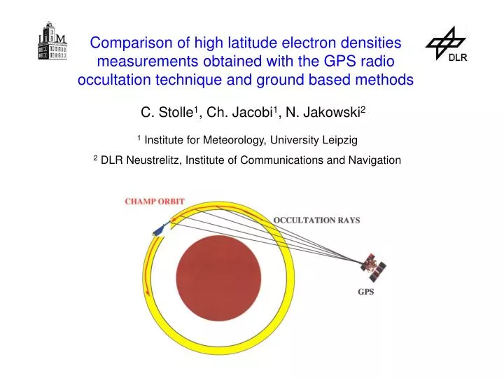
Comparison of high latitude electron densities measurements obtained with the GPS radio occultation technique and ground based methods. C. Stolle 1 , Ch. Jacobi 1 , N. Jakowski 2. 1 Institute for Meteorology, University Leipzig 2 DLR Neustrelitz, Institute of Communications and Navigation.

E N D
Comparison of high latitude electron densities measurements obtained with the GPS radio occultation technique and ground based methods C. Stolle1, Ch. Jacobi1, N. Jakowski2 1Institute for Meteorology, University Leipzig 2 DLR Neustrelitz, Institute of Communications and Navigation
Outline 1. Introduction and intention 2. Electron density profile retrieval using ionospheric CHAMP occultation data 3. Electron densities measured with ionosondes 4. Results of ALOMAR campaign 2001 5. Further comparisons: SIRCUS campaign 2001/2002 6. Conclusions
1. Introduction and intention • CHAMP was launched in July 2000 by the GFZ Potsdam • among other instruments the satellite carries the GPS receiver • GPS allows measurements of the electron content in the ionosphere and plasmasphere • retrieval of electron density profiles possible
Introduction and intention • first profile on April, 11th 2001 • need of comparison with independent instruments (ionosondes, ISR) • ALOMAR/Norway (July/August 2001),local ionosonde could • yield maximum electron density peaks • SIRCUS-EISCAT (Nov. 2001, Feb./May 2002), extension to profile comparisons
2. Electron density profile retrieval using ionospheric CHAMP occultation data • 24 GPS satellites at an • altitude of 20,000 km • transmission of dual • frequency signals • f1= 1575,42 MHz and • f2=1227,6 MHz • signals received by ground • based stations (e.g. IGS) • and LEO satellites (e.g. • CHAMP, in 400 km) source: GFZ Potsdam
2. Electron density profile retrieval using ionospheric CHAMP occultation data • radio waves traverse the ionised atmosphere • signal is affected by free electrons of the • ionosphere (in path, travel time, phase and • polarisation) TEC= Total Electron Content f = frequency Ne = electron density
2. Electron density profile retrieval using ionospheric CHAMP occultation data Radio occultation • vertical scanning through the ionosphere during an • occultation with a GPS satellite
2. Electron density profile retrieval using ionospheric CHAMP occultation data Profile retrieval • electron density profile with application of TEC profile information Abel inversion • Assumptions: • spherical symmetry around the tangential point • (week horizontal resolution) • solution up to an integration constant • model estimation of plasmaspheric electron content (upper boundery problem)
3. Electron density measurements by ionosondes • transmission of a frequency sweep of f= 0.5 –20 MHz • waves are reflected when f = fp • density: • layer height: • vertical scan up to maximum electron density peak Height / km Frequency / Mhz
4. Results of ALOMAR campaign 2001 • comparison of maximum electron density peak values • ionosondes: Andøya - Cadisonde(cross), Tromsø- Dynasonde (triangle) and CHAMP (numbers) • 4 events near Andøya 1,2,3,4 locations of CHAMP profiles
4. Results of ALOMAR campaign 2001 • CHAMP profiles in northward locations to Andøya • NmF2CHAMP ≈ NmF2Iono CHAMP () Tromsø (Δ) Andøya (+)
4. Results of ALOMAR campaign 2001 • southward location or equal latitude location to Andøya • NmF2CHAMP > NmF2Iono CHAMP () Tromsø (Δ) Andøya (+)
4. Results of ALOMAR campaign 2001 • CHAMP/Ionosonde: same order of magnitude (3 – 6 * 1011 m-3) • slight overestimation by CHAMP for these cases
5. Further comparison: SIRCUS campaign 2001/2002 General • SIRCUS = Satellite and Incoherent scatter Radar • Cusp Studies • November 2001, February 2002 and May 2002 • 28 profiling events occurred during all three campaigns • aim: comparison of electron density profiles • measured by CHAMP and EISCAT
5. Further comparison: SIRCUS CAMPAIGN 2001/2002 • blue star: location of EISCAT UHF • red line: CHAMP orbit • lightrose line: ray path (GPSCHAMP) good agreement between CHAMP and EISCAT29.05.02/23:52 UT
5. Further comparison: SIRCUS CAMPAIGN 2001/2002 • similar electron content at Radar location and GPS rays • low electron content gradients (spherical symmetric can be hold) Polar Tec Map • vertical integrated electron content
5. Further comparison: SIRCUS CAMPAIGN 2001/2002 Closest radar beam (ESR32) shows different profile shape. Far beams higher values.Distance dependent?29.05.02/23:52 UT
5. Further comparison: SIRCUS CAMPAIGN 2001/2002 pronounced electron content gradients in the dawn sector (spherical symmetry creates discrepancies ? )
5. Further comparison: SIRCUS CAMPAIGN 2001/2002 Correlation plots 57% -0,15 • all 28 events • ΔHmF2, ΔNmF2 and ΔTEC are functions of the distance of corresponding CHAMP-F2 peaks • Δ = CHAMP – ISR • no significant correlation for distance nor for elevated KP – Index (■) 60% 0,16 64% -0,14
6. Conclusions • good general agreement between CHAMP retrieved occultation data and independent measurements • slight overestimation for low electron densities still under investigations • differences to other profiles are not distance dependent but arise from occultation geometry Stolle, C., Lange, M. and Jacobi, Ch., Validation of atmospheric temperature profiles and electron densities derived from CHAMP radio occultation measurements during measurement campaigns at Andøya (69.28° N, 16.02° E); Rep.Inst. Meteorol. Univ. Leipzig , 2002. Stolle, C., N. Jakowski, K. Schlegel, and M. Rietveld, Comparison of high latitude electron density profiles obtained with the GPS radio occultation technique and EISCAT measurements, Ann. Geophys., submitted