Download
1 / 44
510 likes | 784 Vues
Climate Zones. Climate zones are largely determined by 2 factors:. Temperature and Rainfall. Using data from temperature and rainfall, we can make climographs. Check these 2 graphs. How are they different?.

E N D
Climate zones are largely determined by 2 factors: Temperature and Rainfall
Using data from temperature and rainfall, we can make climographs
Check these 2 graphs. How are they different? What do we know about weather/climate? Which area of the world could these be from?
Areas that have similar rainfall and temperature will share a similar climate zone.
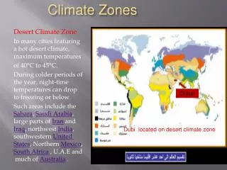
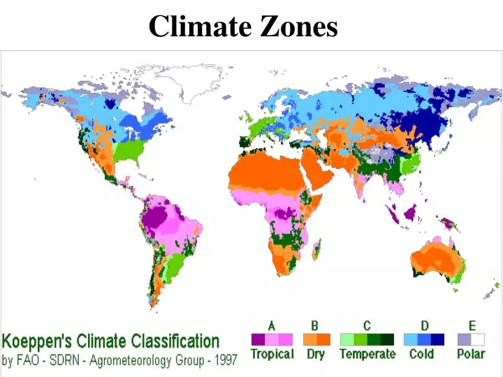
The most widely used for classifying the world's climates. Köppen divided the Earth's surface into climatic regions that generally coincided with world patterns of vegetation and soils.
The Köppen system recognizes five major climate types based on the annual and monthly averages of temperature and precipitation. Each type is designated by a capital letter.
Further subgroups are designated by a second, lower case letter which distinguish specific seasonal characteristics of temperature and precipitation.
To further denote variations in climate, a third letter was added to the code. These letters usually correspond to information about certain months or about max and min temperature or rainfall.
You will not have to memorize all of the letters, but you may have to use charts to look them up
There are 3 basic climate groups Group I Low-latitude Climates Group II Mid-latitude Climates Group III High-latitude climates
Group ILow-latitude Climates: Tropical Moist Climates(Af) rainforest Wet-Dry Tropical Climates(Aw) savanna Dry Tropical Climate (BW) desert biome
Tropical Moist Climates • Average temperature range around 20o - 30o C • Annual Precipitation: 262 cm. (103 in.) • Latitude Range: 10° S to 25 ° N • Global Position: Amazon Basin; Congo Basin of equatorial Africa; East Indies, from Sumatra to New Guinea.
Wet-Dry Tropic Climates • Temperature Range: ~18 °C--25 °C • Annual Precipitation: 0.25 cm. (0.1 in.). All months less than 0.25 cm. (0.1 in.) • Latitude Range: 15 ° to 25 ° N and S • Global Range: India, Indochina, West Africa, southern Africa, South America and the north coast of Australia
Dry Tropical Climate (BW) • Average Annual Temperature (oC) = 22.8 • Annual Precipitation: 0.25 cm (0.1 in). All months less than 0.25 cm (0.1 in). • Latitude Range: 15° - 25° N and S. • Global Range: southwestern United States and northern Mexico; Argentina; north Africa; south Africa; central part of Australia.
Monsoon Tropical Climate (Am) Located usually between 10 and 25o N or S of the equator Average temperature around 26oC Has high annual rainfall but most of it occurs in the rainy season
Mid-latitude Climates: • Dry Midlatitude Climates (BS) steppe • Mediterranean Climate (Cs) chaparral biome • Dry Midlatitude Climates (Bs) grasslands biome
Dry Midlatitude Climates • Temperature Range: 24° C (43° F). • Annual Precipitation: less than 10 cm (4 in) in the driest regions to 50 cm (20 in) in the moister steppes. • Latitude Range: 35° - 55° N. • Global Range: Western North America (Great Basin, Columbia Plateau, Great Plains); Eurasian interior, from steppes of eastern Europe to the Gobi Desert and North China.
Rain forests are characterized by high rainfall, with definitions setting minimum normal annual rainfall between 1,750 millimetres (69 in) and 2,000 millimetres (79 in). Mean monthly temperatures exceed 18 °C (64 °F) during all months of the year.
You can imagine that each climactic zone also share some natural features. What kind of natural features would these places share to some degree?