Download
1 / 53
550 likes | 1.15k Vues
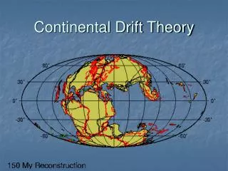
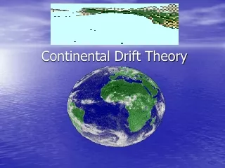
Continental Drift- The Theory. The Earth’s crust is broken into about 12 rigid plates, which slide over a semi-molten plastic layer of the mantle. Tectonic Plates on Modern Earth. There are three types of plate boundaries:. 1- Convergent 2- Divergent 3- Transform.

E N D
The Earth’s crust is broken into about 12 rigid plates, which slide over a semi-molten plastic layer of the mantle.
There are three types of plate boundaries: • 1- Convergent • 2- Divergent • 3- Transform
1. Convergent (aka subduction zone) boundaries – where one plate overrides another plate. Each plate is bounded by some combination of these three plate boundary types. 2. Divergent (aka spreading) boundaries – where plates are moving apart 3. Transform fault boundaries – where plates are moving past each other
The material making up the plates can be divided in two types: i. Oceanic crust ii. Continental crust
The driving force for plate tectonics is slow moving convection currents in the underlying plastic mantle material.
How does convection work? No one knows—but they aren’t afraid to propose models! Whole-mantle convection Two mantle convection cells Complex convection
1600 - development of a comprehensive world map (missing details of some continents such as Australia and Antarctica). 1620 - Francis Bacon noted the similarity of the shape of the continents on either side of the Southern Atlantic – Africa and South America.
1666 - Francois Placet suggested that prior to the Great Flood the land was undivided by oceans and that the Atlantic formed when Atlantis sank. 1858 - Antonio Snider developed a theory that when the Earth cooled from a molten mass continents formed only on one side. This created instability causing the Americas to be pulled away from the rest of the continents.
1879 – Sir George Darwin said that the Pacific Ocean was the scar left behind when the Moon pulled away from the Earth. After this happened, the continents moved to create a balanced planet. 1890s- Edward Suess suggested that at one stage all the continents were joined as one massive continent, which he called Gondwana. His evidence for this was the location of mountain ranges and common fossils.
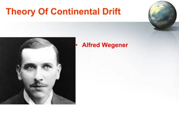
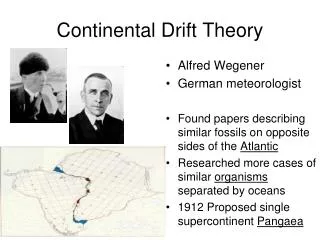
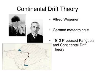
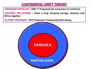
1924 - Alfred Wegener developed the theory of Continental Drift to explain the similarities of rocks, fossils and other geological structures on either side of the Atlantic. At this time it was accepted that the continents sat like icebergs on the mantle and as the continents eroded they rose out of the mantle. Wegener suggested as well as moving up and down in the mantle, continents could move sideways in the mantle. -Wegener was a meteorologist and his theory was not well accepted. (He died on an expedition in Greenland collecting ice samples).
1928 - Arthur Holmes suggested that convection currents in the mantle as the driving force of continental drift. He had no evidence to support his theory. 1950s- Extensive mapping of the ocean floor, especially the Mid-Atlantic Ridge. 1960s- Harry Hess suggested that sea floor separates at the mid-oceans ridges and new sea floor is created by up welling of the mantle. 1970s- Theory of plate tectonics well accepted.
Continental Drift: Evidence • Geographic fit of South America and Africa • Fossils match across oceans • Rock types and structures match across oceans • Ancient glacial features • Earthquake Patterns • Volcano Patterns
Continental Drift: Evidence Tight fit of the continents, especially using continental shelves.
Continental Drift: Evidence Fossil critters and plants
Continental Drift: Evidence Correlation of mountains with nearly identical rocks and structures
Continental Drift: Evidence Glacial features of the same age restore to a tight polar distribution.
The Rise of Plate Tectonics WW II and the Cold War: Military Spending U.S. Navy mapped seafloor with echo sounding (sonar) to find and hide submarines. Generalized maps showed: oceanic ridges—submerged mountain ranges fracture zones—cracks perpendicular to ridges trenches—narrow, deep gashes abyssal plains—vast flat areas seamounts—drowned undersea islands Dredged rocks of the seafloor included only basalt, gabbro, and serpentinite—no continental materials.
The Rise of Plate Tectonics Hypothesis: Stripes indicate periodic reversal of the direction of Earth’s magnetic field. To test this hypothesis, scientists determined the eruptive ages AND the polarity of young basalts using the newly developed technique of K-Ar radiometric dating. The study validated the reversal hypothesis...
The Rise of Plate Tectonics And then (1962-1963) geologists realized that the patterns are SYMMETRICAL across oceanic ridges. The K-Ar dates show the youngest rocks at the ridge.
The Rise of Plate Tectonics Meanwhile, U.S. military developed new, advanced seismometers to monitor Soviet nuclear tests. By the late 1950s, seismometers had been deployed in over 40 allied countries and was recording 24 hrs/day, 365 days/year. Besides the occasional nuclear test, it recorded every moderate to large earthquake on the planet. With these high-precision data, seismologists found that activity happens in narrow bands.
Divergent boundaries: Chiefly at oceanic ridges (aka spreading centers)
How rifting of a continent could lead to formation of oceanic lithosphere. e.g., East Africa Rift e.g., Red Sea e.g., Atlantic Ocean
Presumably, Pangea was ripped apart by such continental rifting & drifting.
Subduction zones form at convergent boundaries if at least one side has oceanic (denser) material. Modern examples: Andes, Cascades Major features: trench, biggest EQs, explosive volcanoes
Another subduction zone—this one with oceanic material on both sides. Modern example: Japan
Collison zones form where both sides of a convergent boundary consist of continental (buoyant) material. Modern example: Himalayas This probably used to be a subduction zone, but all the oceanic material was subducted.