Download
1 / 60
610 likes | 854 Vues
Place& Location Where is it? Longtitude and Latitude, countries. Five Themes of Geography. Place. A part of the earth that can be recognized as separate or different parts from other parts. Each place is a combination of natural physical characteristics Landforms, bodies of water,

E N D
Place& LocationWhere is it? Longtitude and Latitude, countries Five Themes of Geography
Place • A part of the earth that can be recognized as separate or different parts from other parts. • Each place is a combination of natural physical characteristics • Landforms, bodies of water, • Human features like roads, buildings
Place and Location • A place has two types of locations • Relative Location • A place in relation to other palces, using simple directions, landmarks. • Ex. Milton is located about 40 minutes west of Toronto.
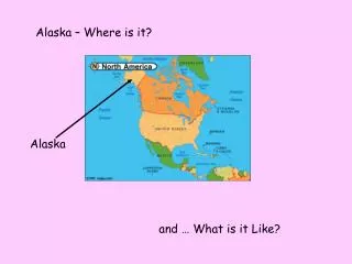
I am a large body of water located near the centre of Canada. I am surrounded by Quebec on the east, Ontario in the south, and Manitoba and the Northwest Territories on the west. To the north are the arctic islands • My name is???
I am an island located in the Gulf of the St. Lawrence. Nova Scotia is to the south and New Brunswick to the west. • My name is???
Location • Absolute Location • A description of a place independent of any other place. The system of longtitude and latitude is used to find an absolute location • The Location of Toronto is 44 degrees north, 79 degrees West.
Longitude and Latitude • There are four hemispheres on earth: • North, South East and Western Hemispheres.
Longitude and Latitude Cont. • Longtitude and Latitude are the imaginary lines that help to split up the different hemispheres. • Together, they help to pin point the exact location of places on maps.
Longtitude • Lines of Longtitude are called Meridians • They run North and South and measure the distance east of west of the Prime Meridian • The Prime Meridian is located in Greenwich, England
Latitude • Lines of Latitude are called parallels • They run east and west on a map • They tell us the distance between of a place either north or south of the equator.
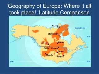
As a class Distribute atlases and lets find the Longitude of these three cities. Yellowknife, NWT Charlottetown, PEI Thunder Bay, ONT
Prime Meridian • The Prime Meridian is the line of zero degrees of longtitude. • It has been used as the world standard for telling time since 1884 by an international agreement.
Universal Time (UT) • Usually stated in a 24 hour clock notation • The time in all other time zones around the world is determined in relation to UT.
24 hour clock • We are accustomed to a 12 hour AM/PM clock. • 24 hour clock starts at zero and finishes at 24. • Ex: what time would 18:25 be in a 12 hour clock system? • 06:35?
Examples of UT • It is 16:35 (UT). What time is it in Winnipeg?
Time Zones • The world is divided into 24 hour time zones • Divided in a longitude direction
Local Time • The time in any given time zone in the world. • Determined in relation to the time at thePrime Meridian.
International date line. • The International Date Line sits on the 180º line of longitude in the middle of the Pacific Ocean, and is the imaginary line that separates two consecutive calendar days. • Immediately to the left of the International Date Line the date is always one day ahead of the date (or day) immediately to the right of the International Date Line in the Western Hemisphere.
Day Light Savings Time • "Daylight Savings Time" – is a way of making better use of the daylight in the evenings by setting the clocks forward one hour during the longer days of summer, and back again in the fall. • The clock moves ahead (= losing one hour) in the spring when DST starts, and falls back one hour (= gaining one hour) when DST ends in the fall.
To remember which way the clock goes, keep in mind one of these sayings: “spring forward, fall back” or “spring ahead, fall behind.” • In 2013, clocks will go forward Sunday March 10th, and will go back an hour Sunday November 3rd .
Movement • We will be introducing movement by using the cornell note taking method. • Please set up your note taking in your binders using the following set up:
Summary • To immigrate, to visit, vacation, business trips, sports travel, for jobs, education, • ???
Riding the Information Highway • Information is another commodity that is always on the move from one place to another • Your task will be to discover ways in which information is moved from place to place: • Use the examples from the previous note to get you jump started.
Interaction The influence of people, places, and things on one another In this sub section, you will come into understanding of two different kinds of interactions: Area interaction and environmental interaction.
Area Interaction • Combines the themes of place and movement • When people, products, and information move between places, those places begin to influence each other • Example: Canadian clothing styles are affected by recent trends coming from top fashion hubs such as New York, Paris, Rome.
Close Area interactions • Within your neighbourhood • Creates mental maps in your head • Example: you definitley know how to get to school despite not knowing all of the street names involved.
Distant area interaction • Today, the internet, emails, satellites, phones, planes, bridges, cars have made interacting in far places much easier and influential on each other.
Environmental Interaction • The environments interaction on humans is called a cause and effect relationship. • The environment influences different human activities in different environments • Climate greatly interacts with humans and causes us to adapt to living in certain conditions.
Northern States are quite accustomed to winter necessities such as: • Being prepared for snow storms • Winter fashion • Participating in winterized sports • Housing with insulation to keep us warm
The southern states are accustomed to warmer temperatures meaning: • Not all houses are properly insulated • Winter sports are not as popular • Harder to find products used for winter weather (tires, snow shoes, snow blowers) • Often times, when rare snow storms hit southern states, it is a disaster due to snow plows not being in existence and drivers failing to drive with snow on the ground.
Humans change the environment • In order to fit to their needs:
A world of Products • Use the Black line master of the world and identify 10 household objects in your home that are made from all over the world besides Canada. • Show the travel path from the country that produces your items to Southern Ontario.
What is the Environment? • Class definition? • Based on landforms, • Climate • Soil • Plants • Animals • Terrain • climate
North of Toronto, stretches from the Niagra Escarpment to The Trenton area in Eastern Ontario • 160 km long and 15 km wide • A moraine is a term used to describe eroded materials left behind by glaciers
Oak Ridges Moraine • The oak ridges moraine formed between the tongues of two glaciers 12 000 years ago
Activity • Please read pages 58-60 in the geography text. • Complete the Oak Ridges Moraine worksheet.