Download
1 / 19
190 likes | 193 Vues
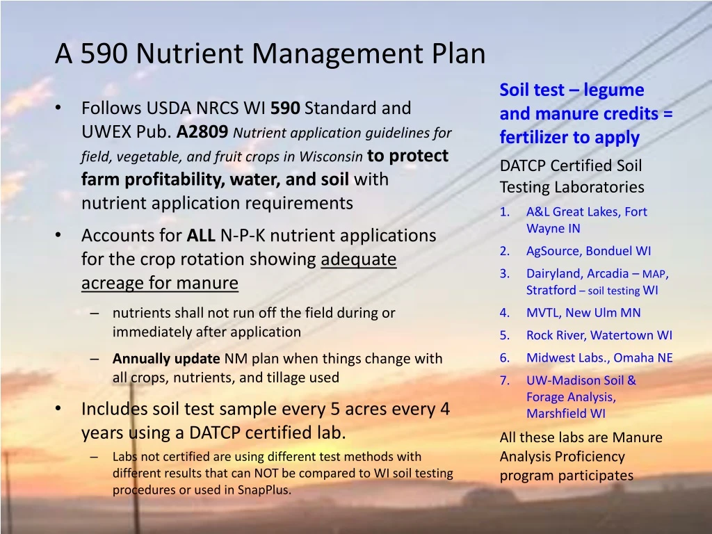
This plan follows USDA NRCS WI 590 Standard and UWEX Pub. A2809 guidelines for nutrient application in Wisconsin. It includes soil testing, accounts for crop rotation, and protects water and soil.

E N D
A 590 Nutrient Management Plan Soil test – legume and manure credits = fertilizer to apply DATCP Certified Soil Testing Laboratories A&L Great Lakes, Fort Wayne IN AgSource, Bonduel WI Dairyland, Arcadia – MAP, Stratford – soil testing WI MVTL, New Ulm MN Rock River, Watertown WI Midwest Labs., Omaha NE UW-Madison Soil & Forage Analysis, Marshfield WI All these labs are Manure Analysis Proficiency program participates • Follows USDA NRCS WI 590 Standard and UWEX Pub. A2809Nutrient application guidelines for field, vegetable, and fruit crops in Wisconsinto protect farm profitability, water, and soil with nutrient application requirements • Accounts for ALL N-P-K nutrient applications for the crop rotation showing adequate acreage for manure • nutrients shall not run off the field during or immediately after application • Annually update NM plan when things change with all crops, nutrients, and tillage used • Includes soil test sample every 5 acres every 4 years using a DATCP certified lab. • Labs not certified are using different test methods with different results that can NOT be compared to WI soil testing procedures or used in SnapPlus.
590 Changes Surface water and groundwater protection • Control soil erosion. When applying manure or organic by-products use either P strategy during the crop rotation of 8 yrs. or less: • Phosphorus P Index≤ 6 or • Manage the Soil Test P, balance STP 50-100, draw down when is >100 PPM • No applications within 50’ of direct conduits to groundwater unless deposited by gleaning or pasturing animals or as corn starter fertilizer. • Do not apply to areas locally delineated by the Land Conservation Committee or in a conservation plan as areas contributing runoff to direct conduits to groundwater unless manure is substantially buried within 24 hours • New: Provides methods for rescue N applications and refining NM recommendations through on-farm research using 590’s Technical Note Appendix 3, Guidelines for Adaptive Nutrient Management • New: Do not apply to areas near public water supplies unless manure is treated to substantially eliminate pathogens. Area within: 1000’ of a Community potable water well= 30,000 [0.3%] cropland acres; or 100’ of a Non-community potable water well= ~ 7,000 [0.1%] cropland acres (church, school, restaurant, taverns, etc....) Total Cropland Data Layer 2015, 2014 NASS with grass/pastures fields = 11,866,674 crop acres
590 criteria for surface water protection Nutrients Applied In Surface Water Quality Management Area (SWQMA) 1000’ from ponds or lakes = 1.33 M [11%] cropland acres and 300’ from rivers or streams = 0.5 M [4%] cropland acres In fall, spring, summer use 1 or more of the following: • Effective incorporation within 72 hours of application • Establish crops prior to, at, or promptly following application • Install/maintain vegetative buffers or filter strips • Maintain ≥ 30% cover after nutrient application • Apply nutrients within 7 days of planting on fields with < 30% cover and have 3 or more consecutive years of no-tillexample corn silage • In the SWQMAorwhere subsurface drainage is presentlimit mechanical applications of unincorporated liquid manure with11.0% or less dry matter to 12,000 gals/acre. Sequential applications may be made to meet the nutrient need waiting at least 7 days between applications. Visually monitor accessible tile outlets before, during, and after applications for discharge of liquid manure or organic by-product. If a discharge is observed, stop applications. Winter - when temperature/snow prevents effective incorporation: • Do not mechanically apply nutrients within the SWQMA;but gleaning or pasturing animals are allowed in SWQMAand on all slopes in winter while following 590.
590 Protecting surface and ground waterWinter, when temperature or snow prevents effective incorporation: No commercial N or P fertilizer application except on pastures and winter grains. Farms mechanically applying manure or organic by-products must have a Winter Spreading Plan: amount available storage, winter applied, or generated in 14 days, whichever is greater. • Do not exceed the P removal of the following growing season’s crop. Limit liquid manure applications to 7,000 gal/acre. All winter manure applications 60 lbs. of P2O5/ac or less. New: • Do not apply within 300 feet of direct conduits to groundwater. • Do not surface apply liquid manure during February and March on: • DNR Well Compensation areas funds provided to replace wells when contaminated with livestock manure= 6,400 [0.1%] cropland acres or • Silurian dolomite within 5 feet of soils surface = 83,500 [1%] cropland acres. • Do not apply where concentrated flow channels are present (options 1.- 7.) oron slopes > 6% (options 1.- 5.) = 3.1 M [26%] unless 2 practices are used: • Contour buffer strips or contour strip cropping • Leave all crop residue and no fall tillage • Apply manure in intermittent strips on no more than 50% of field • Apply manure on no more than 25% of the field during each application waiting a minimum of 14 days between applications • Reduce manure app. rate to 3,500 gal. or 30 lbs. P2O5, whichever is less • No manure application within 200 feet of all concentrated flow channels • Fall tillage is on the contour and slopes are lower than 6%
590 criteria for groundwater protection New: Nitrogen(N) restricted soils limit N applicationsto A2809 and these 590 rates for all N sources to reduce leaching. • Late summer or fallcommercial N fertilizer rates on fall seeded crops or commercial fertilizers blends needed, Pub. A2809. Do not exceed 36lbs. N/ac. on these features: (P) high permeability soils = 1.3 M [11%] cropland acres]Use 1 of 3 practices to reduce springleaching (R) rock soils with less than 20 inches to bedrock = 235,000 [2%] cropland acres] (W) wet soils with less than 12 inches to apparent water table= 1.5 M [13%] cropland acres] Soil depth 5 feet or less over bedrock = 1.8 M [15%] cropland acres] Within 1,000 feet of a community well = 30,000 [0.3%] cropland acres ] All = 4.7 M [39%] cropland acres • Late summer or fall manure or organic by-products rate limits do not smother crops: Use ≤ 120 lbs. available N/acre P& Rsoilson all crops, except annual crops. Additionally, manure with ≤ 4% DM wait until after soil temp. < 50°F or Oct. 1 use either a nitrification inhibitor or leave on surface for 3 days. W soils or combination W soils on all crops. Additionally, manure with ≤ 4% DM on all crops use at least 1 of 5 practices: 1. Use nitrification inhibitor. 2. Apply on an established cover crop, an overwintering annual, or perennial crop. 3. Establish a cover crop within 14 days of application. 4. Surface apply and do not incorporate for at least 3 days. 5. Wait until after soil temp. < 50°F or Oct. 1. Use ≤ 90 lbs. available N/acre P& Rsoilswait until after soil temp. < 50°F or Oct. 1 on annual crops. Additionally, manure with ≤ 4% DM on all crops use either a nitrification inhibitor or leave on surface for 3 days. W soils or combination W soils ≤ 4% DM on all crops.
NW and NE Existing and New Fall N Restriction Cropland Areas View current & proposed 590 restrictions at http://snapplus.wisc.edu/maps • Total cropland in WI (11,866,674 acres). • Cropland Data Layer as the source of cropland acreage data. Grass/pasture was include in the cropland total. • USDA National Agricultural Statistics Service Cropland Data Layer. 2015. Published crop-specific data layer. Available at https://nassgeodata.gmu.edu/CropScape/ USDA-NASS, Washington, DC.
SC Existing and New Fall N Restriction Cropland Areas View current & proposed 590 restrictions at http://snapplus.wisc.edu/maps • Total cropland in WI (11,866,674 acres). • Cropland Data Layer as the source of cropland acreage data. Grass/pasture was include in the cropland total. • USDA National Agricultural Statistics Service Cropland Data Layer. 2015. Published crop-specific data layer. Available at https://nassgeodata.gmu.edu/CropScape/ USDA-NASS, Washington, DC.
SWExisting and New Fall N Restriction Cropland Areas • Total cropland in WI (11,866,674 acres). • Cropland Data Layer as the source of cropland acreage data. Grass/pasture was include in the cropland total. • USDA National Agricultural Statistics Service Cropland Data Layer. 2015. Published crop-specific data layer. Available at https://nassgeodata.gmu.edu/CropScape/ USDA-NASS, Washington, DC. View current & proposed 590 restrictions at http://snapplus.wisc.edu/maps
NC Existing and New Fall N Restriction Cropland Areas • Total cropland in WI (11,866,674 acres). • Cropland Data Layer as the source of cropland acreage data. Grass/pasture was include in the cropland total. • USDA National Agricultural Statistics Service Cropland Data Layer. 2015. Published crop-specific data layer. Available at https://nassgeodata.gmu.edu/CropScape/ USDA-NASS, Washington, DC. View current & proposed 590 restrictions at http://snapplus.wisc.edu/maps
NE Existing and New Fall N Restriction Cropland Areas • Total cropland in WI (11,866,674 acres). • Cropland Data Layer as the source of cropland acreage data. Grass/pasture was include in the cropland total. • USDA National Agricultural Statistics Service Cropland Data Layer. 2015. Published crop-specific data layer. Available at https://nassgeodata.gmu.edu/CropScape/ USDA-NASS, Washington, DC.
SE Existing and New Fall N Restriction Cropland Areas • Total cropland in WI (11,866,674 acres). • Cropland Data Layer as the source of cropland acreage data. Grass/pasture was include in the cropland total. • USDA National Agricultural Statistics Service Cropland Data Layer. 2015. Published crop-specific data layer. Available at https://nassgeodata.gmu.edu/CropScape/ USDA-NASS, Washington, DC. View current & proposed 590 restrictions at http://snapplus.wisc.edu/maps
Proposed NR 151 Targeted Performance StandardSearch – “NR 151 draft rule” available now • The revision relates to proposed standards for WI and manure application restrictions where Silurian Dolomite is present. http://dnr.wi.gov/news/input/documents/rules/WT1516DraftRule.pdf • Manure spreading prohibitions on shallowest Silurian bedrock soils • Manure application rate, timing, and advanced treatment requirements on Silurian bedrock soils NR 151.015(17) “Silurian bedrock” means the area in Wisconsin where the bedrock consists of Silurian dolomite or is part of the Maquoketa Formation overlain by soils of 20 feet or less. This area comprises portions of the following counties: Brown, Calumet, Dodge, Door, Fond du Lac, Kenosha, Kewaunee, Manitowoc, Milwaukee, Outagamie, Ozaukee, Racine, Walworth, Washington and Waukesha. Areas where Silurian bedrock occurs in Wisconsin can be identified by the most current NRCS, WGNHS, or county maps and infield bedrock verification methods. • Public hearing Sept. ? Green Bay with Skype locations in Madison(DNR, GEF2 room 090) and Eau Claire (DNR Service Center) • CAFOs will have to comply with new standards immediately • Understand how these changes will affect you and your customers • Review the rule and provide suggestions/comments to DNR and be specific!
Mapped Cropland within Silurian dolomite area 39,880 cropland acres 0-2 feet 43,620 cropland acres 2-5 feet 83,500 total cropland acres 0-5 feet of soils surface
3,921 dairy or beef livestock farms are located within the WI Silurian dolomite area
State Statutes direct ATCP 50 Wis. Admin. Code To provide education, incentives, and conservation compliance. It describes how farms may be required to do NM with a cost share $ offer or without cost share if: Causing a significant discharge Regulated by DNR WPDES CAFO permit or localordinance manure storage or livestock siting Accepting manure storage cost share Participating in the Farmland Preservation Exceeding state standards ATCP 50.04is only allowed if approved by either DATCP or DNR. A person may challenge a local regulation at the local level and in court if the person believes that the local governmental unit has violated state standards in NR 151 and ATCP 50. Manure Storage Ordinance