Download
1 / 22
220 likes | 324 Vues
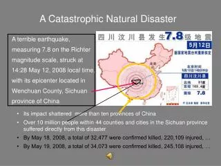
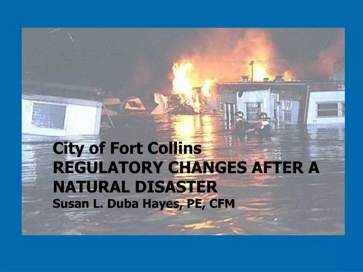
City of Fort Collins REGULATORY CHANGES AFTER A NATURAL DISASTER Susan L. Duba Hayes, PE, CFM. The Event. The Fort Collins flood was the biggest natural disaster to ever affect the city (in 130 years of record).

E N D
City of Fort CollinsREGULATORY CHANGES AFTER A NATURAL DISASTERSusan L. Duba Hayes, PE, CFM
The Event • The Fort Collins flood was the biggest natural disaster to ever affect the city (in 130 years of record). • Largest 24-hour rainfall ever to fall on a Colorado urban area. (Total rainfall: 14.5” in 31 hours) • $250m in total damage. • Flow on Spring Creek exceeded the 500-year event.
Ft. Collins Floodplain Facts: Before the Flood • Approximately 3,280 acres of floodplain and 1,828 structures located in the 100-year floodplain. • Four FEMA designated floodplains and three locally designated floodplains. • Regulated to a higher standard than FEMA. • Rated as a Class 6 by CRS. • Capital Project program to fund drainage projects. EXISTING HIGH CALIBER PROGRAM
WE WERE STILL CRITICIZED • Citizens asked: • Why did you let us (or them) build there? • Why didn’t you tell us we were at risk? • Why didn’t the irrigation canals capture all the water? • How could you let this happen to us? • Why didn’t you plan for bigger storms? We’re in a “preferred storm track”. REGULATION CHANGES WERE DRIVEN BY CITIZENS
Regulatory ChangesTwo Major Initiatives • Rainfall • Higher 100-year rainfall adopted in 1999 (less than 2 years from flood) • 2007 – rainfall standard re-visited and upheld. • Floodplain Regulations • Poudre River – adopted in 2000 (three years from flood) • Remainder of City – adopted in 2005 (almost 8 years from the flood, 3 years of outreach!) • Poudre River – revised downward in 2007 (10 years later)
Rainfall(Round One) • January 1998, Utilities began reevaluation of rainfall. • Task Force guided the study. • Could not wait for NOAA’s revised study to be completed in 3-5 years, (still not started). • City embarked on own study.
Variety of Opinions Regulatory agencies: • Federal Emergency Mgmt. Agency • Colorado Water Conservation Board • Larimer County • City of Fort Collins Utilities • Colorado State University Facilities • Fort Collins Water Board Technical Experts: • Colorado State University: • Atmospheric Science Department • Engineering Department • Statistics Department • Local Consultant Interested Citizens: • Planning and Zoning Board member • Citizen flooded in 1997
FINAL RECOMMENDATION • Increased 100-year design storm by 27%. • Minority group within the Task Force wanted an even higher rainfall. • Had regional effect: adopted by Wellington, Larimer County, and Windsor. • Placed added responsibility on the City to update all floodplains except the Poudre River.
Floodplain Regulation Revisions: Round One • Poudre River was first. • Discharge wouldn’t change because of new rainfall values • Perceived as greatest flood threat to the community • Potential for “lost opportunities” • Strong push by environmentalists to reevaluate regulations (citizen initiated).
City Advisory Boards Business Interests Environmental and Recreation Interests Technical Experts Real Estate Interests Floodplain Property Owner Emergency Response Task Force Members
Floodway Width Floodway Modification Flood Protection Projects Property Purchase Notification Fill Removal from Floodplain New Development Mobile Home Parks Residential/ Commercial Development Remodels Additions Redevelopment Critical Facilities Riparian Areas Dry Land Access Floatable Materials Variances Lowest Floor Elevation Complex Issues DIFFICULT TO CONVEY COMPLEX TECHNICAL ISSUES TO LAY PEOPLE
Result: More Restrictive Regulations • Product Corridor ( 500 year Depth x Velocity > 6) • One-tenth foot floodway • Higher Freeboard – 2 feet • More restrictions on uses in floodway and Product Corridor • Dryland access required • Floatable materials restricted
Floodplain Regulations: Round 2 • Started in 2002, after new floodplains mapped. • Now had 3600 acres of floodplain with 3300 structures at risk. • No Task Force. • Recommended changes generated by City staff.
Staff’s Approach to Floodplain Regulations • Balance risk with regulation • Map a floodway where practical • More restrictive regulations in the floodway area, less restrictive in the flood fringe • More restrictive for new development, less restrictive for existing development • More restrictive for residential, less restrictive for nonresidential
Result: Some Regulations Are More Restrictive • More Restrictive • No new residential in floodway. • No new mobile home parks in floodplain. • Non-residential: no new basements in floodway.
Result: Most Changes Less Restrictive • Less Restrictive • Changed No-Rise floodplains to FW/FF. • Reduced freeboard to 6” for remodel/additions to existing structures. • Critical facilities allowed in 100-year Moderate Risk. • General Manager can waive regulations in city floodplains if a capital project is underway. • Substantial Improvement: • No longer cumulative over lifetime of structure, tracked for 1 year. • Improvements above flood level not counted (less than FEMA minimum): city floodplains only.
Floodplain Regulations – Round 3Poudre River • Started in 2006 (nine years after flood). • Initiated by policy makers. Changes in 2000 were an “over-reaction” to the flood. • Problem defined as “the City and Larimer County regulations need to match”. • Good outcomes: removed Product Corridor and Dryland Access. • Reduced regulations: narrower floodway, allows floodway modifications, hazardous materials in 500-year FP
2007 – Rainfall Revisited(Round Two) • Focus shifted back to rainfall as the “source” of our program’s “problems”. • A specific capital project was being criticized for being over-sized, too expensive and adversely impacting a natural area. • City Council re-affirmed the rainfall criteria after our August 2007 storm.
Conclusions • Process takes a long time. • Take advantage of community’s initial awareness to make changes. • Excellent opportunity to verify with community the validity of regulations. • Excellent opportunity to modify code for easier use. • Over time, memories will fade and initial objectors may return to roll back changes. • Don’t count on the initial supporters to return. • Hope for another big storm to prove your point.
Summary in Quotes • “I’ll never brag about the City’s stormwater program again.” Ann Azari, Fort Collins Mayor November, 1997 • “ I think we might have a program on steroids.” Kelly Ohlson, City Councilman July, 2007 • “Floods are merely a hazard… Mankind is the disaster.” Gilbert White Natural Hazards Research Center