Download
1 / 27
270 likes | 393 Vues
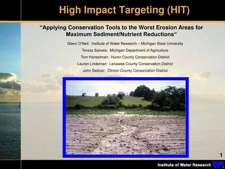
High Impact Targeting (HIT). “Applying Conservation Tools to the Worst Erosion Areas for Maximum Sediment/Nutrient Reductions“. Glenn O’Neil: Institute of Water Research – Michigan State University Teresa Salveta : Michigan Department of Agriculture

E N D
High Impact Targeting (HIT) “Applying Conservation Tools to the Worst Erosion Areas for Maximum Sediment/Nutrient Reductions“ Glenn O’Neil: Institute of Water Research – Michigan State University Teresa Salveta: Michigan Department of Agriculture Tom Hanselman: Huron County Conservation District Lauren Lindeman: Lenawee County Conservation District John Switzer: Clinton County Conservation District
HIT Model SEDMOD1 Land Cover Surface Roughness Delivery Ratio Soil Texture Weighting Soil Clay Content Distance to Stream DEM Sediment Yield LS Factor C Factor Landuse/Tillage K Factor Soil Erosion Soil Erodibility R Factor Rainfall P Factor Support Practice • Fraser. May 1999 • Renard, Foster, Weesies, McCool, Yoder. 1996. RUSLE2
Early Targeting Efforts • DaOuyang (IWR), Jon Bartholic (IWR), Jim Selegean (ACE) • - Coarse Great Lakes Basin analysis1 1. Ouyang, et al., 2005.
Early Targeting Efforts Estimated Total Sediment Loading by 8-digit Watershed 1. Ouyang, et al., 2005.
Conservation Innovation Grant A multi-scale partnership • Project oversight • Funding - Federal: • Project coordination • Outreach - State: • Model and Web • development - University: - Local: • Conservation Districts • Clinton • Huron • Lenawee • Model evaluation • Website feedback • Outreach • BMP targeting
Conservation Innovation Grant Apply conservation tools to the worst erosion areas for maximum sediment/nutrient reductions. Project Goal: Timeframe: 2007 - 2009 Pilot Areas: Three Michigan watersheds Pigeon-Wiscoggin Maple Raisin
Targeting Sub-watersheds (Lower Maumee River Watershed – NW Ohio)
Applying BMP (no-till) on highest risk acres in contrasting watersheds
Spatially exploring areas at high-risk for sediment loading A site in the Maple River Watershed: 0.2 – 0.4 tons/acre 0.4 – 0.8 tons/acre Corn residue runoff in ditch. > 0.8 tons/acre
Making the Data Web-Accessible: www.iwr.msu.edu/hit Analyze data at different watershed scales Work with single, all, or subset of sub-watersheds View data in multiple formats View sediment loading or erosion data Optionally evaluate a BMP
Making the Data Web-Accessible: Table Results Estimated sediment loading BMP impact and cost/benefit Columns can be sorted. Basic watershed info. BMP costs can be recalculated on-the-fly
Making the Data Web-Accessible: Viewing the data spatially
Team Effort • Development of HIT was a team effort: • Clinton C.D. – John Switzer • Huron C.D. – Tom Hanselman • Lenawee C.D – Lauren Lindeman • Michigan Dept. of Ag. – Teresa Salveta • Provided feedback on HIT • Facilitated public outreach • Helped define HIT’s appropriate audiences • Assessed HIT model through field evaluations and stream monitoring
Field Evaluations The C.D. technicians visited over 200 fields in the pilot watersheds and evaluated the accuracy of the high-risk maps.
Field Evaluations Results: 70% of the time HIT maps correctly characterized the landscape. locations.
Field Evaluations Primary causes of errors at other 30%: - Coarse land cover input (30-meter resolution) - DEM unable to accurately characterize flow-direction
Stream Monitoring MDA and Conservation Districts are currently evaluating HIT sediment estimates. • NHD Plus catchments (average size 700 acres) were ranked by sediment loading through HIT. . • C.D. Technicians took samples during weather events and sent them to Michigan DEQ for analysis. - IWR will utilized DEQ results to determine if HIT adequately ranked catchments by sediment loading NHD Plus catchments of the River Raisin Watershed
HIT Highlights • Conservation districts are using HIT to prioritize efforts. • HIT data is being viewed within the NRCS Toolkit, integrating HIT into the workflow of conservation technicians. • Michigan DEQ is promoting HIT in the development of 319 plans. Clinton C.D. and consultants have used it in Maple River 319 plan.
HIT Limitations • Focused primarily on agricultural lands, not suitable for urban analysis. • Focused on sheet erosion (RUSLE), not gully, bank, or wind. • Estimates of erosion and sediment loadings are for relative comparisons of watersheds, are not precise.
HIT “2.0” What’s Next? - Built on Microsoft Bing Maps - Available for the entire Great Lakes Basin - Allows for analysis at all watershed scales
HIT 2.0 • Select watersheds for analysis spatially, by name, HUC, or address.
HIT 2.0 • HIT tables can be generated as in the original system.
HIT 2.0 Least loading per acre Less loading per acre More loading per acre Most loading per acre • Watersheds can be shaded by erosion or sediment data.
HIT 2.0 • Improved aerial imagery allows for richer field-level analysis.
In Conclusion • Through the development of HIT, this CIG project has helped local conservation districts prioritize efforts to reduce erosion and sediment loading from agricultural lands. • Field evaluations have shown HIT’s high-risk maps to be reliable. • Stream monitoring assessments are underway to evaluate HIT’s relative erosion and sediment loading estimates. • An enhanced, Great Lakes basin-wide version of HIT will be available soon.
References Fraser, R. SEDMOD: A GIS-based Delivery Model for Diffuse Sources Pollutants (doctoral dissertation). Yale University. May 1999. Ouyang, D.; Bartholic, J.; Selegean, J. "Assessing Sediment Loading from Agricultural Croplands in the Great Lakes Basin." The Journal of American Science. Vol. 1, No. 2, 2005. Renard, K.; Foster, G.; Weesies, G.; McCool, D.; Yoder, D. Predicting Soil Erosion by Water: A Guide to Conservation Planning with the Revised Universal Soil Loss Equation (RUSLE). USDA, Agriculture Handbook Number 703. 1996.
Thank You oneilg@msu.edu