Download
1 / 15
150 likes | 232 Vues
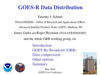
STAR and GOES-R. Presented by Timothy J. Schmit. Requirement, Science, and Benefit. Mission Goals Advancing space-based data collection capabilities and associated platforms and systems Advancing in situ and surface-based data collection capabilities and associated platforms and systems

E N D
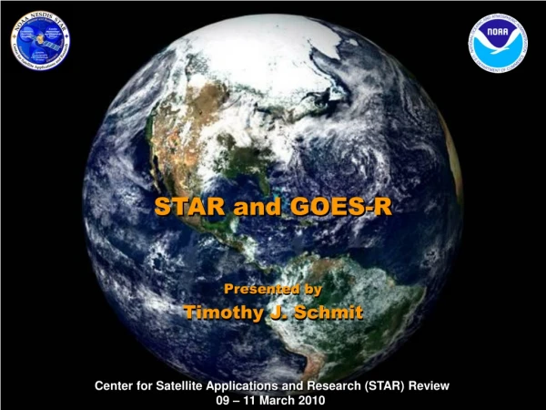
STAR and GOES-R Presented by Timothy J. Schmit
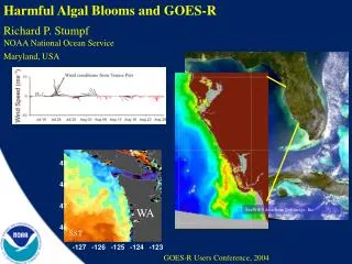
Requirement, Science, and Benefit Mission Goals • Advancing space-based data collection capabilities and associated platforms and systems • Advancing in situ and surface-based data collection capabilities and associated platforms and systems • Overall observing systems architecture design • Data management, associated visualization technology and models, and related high performance computing and communication Science • What improvements to observing systems, analysis approaches, and models will allow us to better analyze and predict the atmosphere, ocean, and hydrological land processes? • How are uncertainties in our analyses best estimated and communicated? • How do we ensure data and product continuity? • How best to exploit temporal and other attribute? Benefits • GOES-R will improve support for the detection and observations of meteorological, oceanographic, climate, and environmental phenomena that directly affect public safety, protection of property, and ultimately, economic health and development • Advanced imager-related incremental benefit of at least $4.6 B, when looking at just 5 sectors. • STAR saved ~ $400M by showing that the ABI could produce legacy sounder products.
Challenges and Path Forward • Science challenges • Exploit the time component of geostationary measurements • Prepare for operational readiness of “Day 1” products. • Better combine GOES and other data sources • Define better methods for product validations • Next steps • Continue GOES-RRR activities • Continue AWG (ATBDs, etc.) support in preparation for product generation • Continue and expand Proving Ground activities with the NWS and others • Prepare for any waiver requests • Education/Training (SME/COMET) advanced soundings • “Day 2” new products • Calibration (Calibration Working Group) and Validation • Continue to prepare for operational use of GOES-R • Transition Path • Continue AWG and other efforts in support of “Day 1” operational products being produced and validated. • Prepare for any needed updates to “Day 1” products and start “Day 2” products.
GOES-R main instruments ABI – Advanced Baseline Imager Space Weather/Solar ABI covers the earth approximately five times faster than the current Imager. Geostationary Lightning Mapper Images courtesy of SOHO EIT, a joint NASA/ESA program
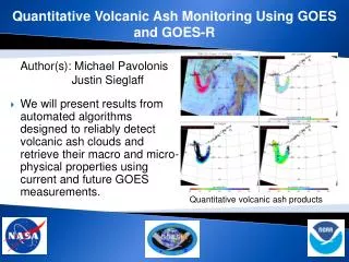
STAR/GOES-R science supports all Mission Goals Simulated ABI RGB Air Mass Product with Lightning SST Volcanic Ash Fire mask product from MODIS observations
Mission Planning • Very involved during the early GOES-R series development. • This includes: formulation studies for both ABI and advanced geostationary sounder, ABI band selection and modification, Technical Requirement Documents, Performance and Operational Requirements Document, etc. ABI/ABS Requirements. circa 1999/2000 Originally ABI was only 8 spectral bands, now it is 16. All ABI bands were modified with input from STAR and it’s Cooperative Institutes.
Current GOES-R Activities • Current activities include: • GOES-RRR (Risk Reduction) • AWG • ATBDs • Calibration Working Group • Proving Ground • Waiver requests • Education/Training • SME (Subject Matter Expert) • COMET (Cooperative Program for Operational Meteorology Education and Training ) • VISITview • web pages • Presentations/papers
Current GOES-R AWG Activities • Algorithm Working Group (AWG) represented by Critical Design Review (CDR) and Algorithm Theoretical Basis Document (ATBD) and Teams GOES-R AWG teams • Imagery • Soundings • Winds • Clouds • Aviation • Hydrology • Land Surface • Cryosphere • Radiation Budget • Lightning • Space Environment • SST and Ocean Dynamics • Aerosols / Air Quality / Atmospheric Chemistry • Proxy Data • Cal/Val (sensor) • Algorithm Integration ATBD CDR
GOES-RRR (Risk Reduction) Blended TPW Risk Reduction supports science and outreach activities that are needed for users to fully exploit all GOES-R instruments and capabilities. STAR-led activity. GOES-RRR supported at least 35 referred publications from 2007 to 2009.
STAR related Training and Education COMET (under construction)
GOES-R Proving Ground The GOES-R Proving Ground engages NWS and other state and local offices in pre-operational demonstrations of selected capabilities of next generation GOES.
New product (Convective Initiation) being demonstrated from GOES in operational AWIPS with Sullivan (MKE) NWS Office CI likely CI occurring Lightning 05:02 UTC 04:30 UTC 06:30 UTC Forecaster generated screen captures from AWIPS at MKE. Product from UW/CIMSS Satellite product leads the radar signature
Future Activities • Continue current activities, plus: advanced geo soundings (possible commercial data-buy option), future/Day 2 products, calibration, validation, outreach, training, etc. Participate in NASA’s GEO-CAPE mission for coastal water and air quality monitoring. (with COMET)
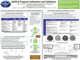
Algorithm Validation Strategy Aeronet StationsAerosol Optical Depth CALIPSO, CLOUDSATClouds, Icing Buoys, ShipsSST SURFRAD, ARMLST, Radiation Sfc Snow Reports, NESDIS IMSSnow Radiosondes Winds, Temperature, Moisture, Stability Rain GaugesPrecipitation NWP AnalysesWinds, Temperature, Moisture National Lightning Detection Network (NLDN)Lightning Pilot ReportsIcing,Turbulence Ground-based OzoneOzone A wide variety of reference (“Ground Truth”) datasets have been assembled and are being used… GOES-R AWG Product Application Teams and the Proxy Data Team have assembled a wide variety of “Ground Truth” datasets to use for Level-2 product validation activities
Challenges and Path Forward • Science challenges • Exploit the time component of geostationary measurements • Prepare for operational readiness of “Day 1” products. • Better combine GOES and other data sources • Define better methods for product validations • Next steps • Continue GOES-RRR activities • Continue AWG (ATBDs, etc.) support in preparation for product generation • Continue and expand Proving Ground activities with the NWS and others • Prepare for any waiver requests • Education/Training (SME/COMET) advanced soundings • “Day 2” new products • Calibration (Calibration Working Group) and Validation • Continue to prepare for operational use of GOES-R • Transition Path • Continue AWG and other efforts in support of “Day 1” operational products being produced and validated. • Prepare for any needed updates to “Day 1” products and start “Day 2” products.