Download
1 / 14
140 likes | 255 Vues
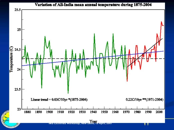
Regional Climate Modelling over Southern Africa Mary-Jane M. Kgatuke. South African Weather Service. The effect of topography. DARLAM TOPO. CSIRO GCM TOPO. MAX TEMP. MAX TEMP. DARLAM CSIRO Atmospheric Research, Australia Configuration over Africa. 0º. Africa. 10º. 20º. 30º. 40º. 10º.

E N D
Regional Climate Modelling over Southern Africa Mary-Jane M. Kgatuke South African Weather Service
The effect of topography DARLAM TOPO CSIRO GCM TOPO MAX TEMP MAX TEMP
DARLAMCSIRO Atmospheric Research, AustraliaConfiguration over Africa 0º Africa 10º 20º 30º 40º 10º 20º 40º 50º 0º 30º 100 x 100 grid points on a Lambert Conformal Projection(60x60 km resolution) 18 sigma layers in the vertical Boundary values supplied by CSIRO9 (R21) AGCM – crosses Semi-Lagragian advection & McGregor cumulus convection parameterization Time step of 15 minutes integrating the hydrostatic equations forward in time SIMULATES 30 DAYS IN 2 HOURS ON A LOCAL COMPUTER @ LRAM
Basis climateaverage over 10 years 1991 - 2000 2021 - 2030 2051 - 2060 REGIONAL SCALE CLIMATE CHANGE SCENARIO MODEL SIMULATIONS OVER SUB-SAHARAH AFRICA Three 10-year regional model simulations forced by the global CSIRO-9 (R21) AGCM for the A2 SRES scenario
January 2021 - 2030January 2051 - 2060 MIN TEMP ANOMALY MIN TEMP ANOMALY MAX TEMP ANOMALY MAX TEMP ANOMALY
January 2021 - 2030January 2051 - 2060 MSLP ANOMALY MSLP ANOMALY RAINFALL ANOMALY RAINFALL ANOMALY
Models • Models tend to be set up according to the performance of physical parameterizations chosen to represent different processes. • The performance of the models will be different and therefore it is necessary to use different models for the same target area.
Models implemented in South Africa • Regional climate studies • DARLAM at the University of Pretoria • RegCM2 at the South African Weather Service • Short term forecasting at the South African Weather Service • ETA (operational) • MM5
RegCM2 over Southern Africa • RegCM2 has been used to simulate tropical cyclone-like vortex tracks in the southern Indian Ocean • Resolution:60 km • Forcing fields: ECMWF • Cumulus parameterization: Grell • Time step :150 s
Objectives of the project with RegCM3(1) • Examine the skill of RegCM3 in simulating regional climate over southern Africa. • Determine the extent to which the simulations are compromised by errors in predicted SST’s and GCM output. • Determine if RegCM3 is capable of simulating the variability between wet and dry periods.
Objectives of the project with RegCM3(2) • Determine the skill of RegCM3 in capturing extreme rainfall events.
Thank you Thank you