Download
1 / 30
300 likes | 450 Vues
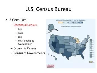
US Census Bureau. West Virginia GIS Conference June 2 – June 5, 2014 Anne Jeffers Geographer. Overview. Geographic Support System Initiative (GSS-I) Boundary and Annexation Survey Census Geographic Products. Geographic Support System Initiative (GSS-I) . Expanded Partnerships

E N D
US Census Bureau West Virginia GIS Conference June 2 – June 5, 2014 Anne Jeffers Geographer
Overview • Geographic Support System Initiative (GSS-I) • Boundary and Annexation Survey • Census Geographic Products
Geographic Support System Initiative (GSS-I) Expanded Partnerships Lead to Improved Data Quality
Key Components of the GSS-I Address Updates An integrated program that utilizes a partnership program for: • Improved address coverage • Annual, transaction-based address and spatial feature updates • Enhanced quality assessment and measurement 123 Testdata Road Anytown, CA 94939 Lat 37 degrees, 9.6 minutes N Lon 119 degrees, 45.1 minutes W Quality Measurement Street/Feature Updates
The GSS-I Partnership Program • Launched in October 2012 • Opportunity for tribal, state, county, and local governments to continually share address &spatial data with the Census Bureau • Recognizes local governments as a definitive authority for quality address and street data within their communities • Leverages the Census Bureau’s broad partner network to encourage participation
Benefits of Participation • Expanded ROI – encourages re-use of local government geospatial data investment • Increases usage of high-quality local government data for multiple federal programs, ie: the 2020 Census and the USGS National Map • Provides maximum input into the American Community Survey. • closes the gap between partner addresses and Census addresses for Local Update of Census Addresses (LUCA) program in 2020.
Targeted Canvassing in 2019? 2009 Address Canvassing 100% Canvassing vs 2019 Targeted Canvassing
What is the Basic Process? • Research and identify potential data partners. • Acquire partner data and perform Content Verification to determine general usability • Crosswalk, standardize, match, and geocode partner addresses and structure points using the Master Address File (MAF) • Match street centerline data to identify differences, calculate spatial accuracy using GPS control points • Ideal Scenario: new addresses are added to the MAF, new streets are added to TIGER, address and spatial inconsistencies are resolved
Partner Data Acquisition * Some counties provided multiple partial-coverage street centerline datasets (i.e., cities vs. balance of county) ** Includes feature and address files processed through the MAF/TIGER system update process
Observations from Content Verification • Incomplete metadata – projection, datum, data dictionaries, etc. • Coverage gaps – some counties excluded data for incorporated cities within their legal jurisdiction • Frequent call-backs for explanations and missing data – i.e., missing Interstate Highway layer, cryptic building use codes, etc. • Failure to meet minimum Street Feature Guidelines – limits the uses for partner-provided data (i.e., street matching, attribute harvesting, coordinate enhancement)
WVDHSEM Dataset • State-wide, consistent • Current – within the last 2 years • Complete Metadata • Meets GSS-I minimum data Guidelines • Residential vs Non-Residential
Minimum Address Guidelines - MATCHING To successfully match to the MAF, a partner address must include: • Complete Address Number • Complete Street Name AND at least one of the following: • Address Coordinate (latitude, longitude) • ZIP Code • Postal City and State • Census 2010 Tabulation State, County, Tract and Block Code This minimum information allows the Census Bureau to update the source data for an existing MAF address record, adding to our confidence that the address is valid.
Minimum Address Guidelines - GEOCODING In order to update the location (geocode) for an existing MAF address, the partner address must meet the MATCHING requirements above, and also provide one of the following data items: • Address Coordinate (latitude/longitude) or • Census 2010 Tabulation State, County, Tract and Block Code
Minimum Address Guidelines – ADDS To ADD new partner addresses to the MAF, the partner address data must: • meet the MATCH requirements above, and • include an address type indicator identifying the address as residential, commercial, utility, etc. and • not already exist in the MAF
Minimum Address Guidelines – within UNIT IDENTIFIERS For residential addresses with multiple units (i.e., apartments, condos, etc.), the partner address data should provide: • a unique Within Structure Identifier(apartment #, unit #, etc.) to distinguish each unit from other units at the same Basic Street Address (BSA). or, if a Within Unit Identifier is not available or does not exist: • The number of units at the BSA (i.e. “123 Main Street - 25 Units”) and • A flag indicating which addresses are multi-unit structures
Block Level Address Feedback • Consists of block tallies detailing: • What the partner provided • Number of records matched or added to the Census address list • Number of records not accepted • Total number of records currently in the MAF
Interactive Review and Update • The Census Bureau performs an interactive review of the potential new and misaligned streets using the partner data and current imagery • In this example, the green-blue lines indicate street updates made by the Census Bureau based on the partner data • The Census Bureau added 39 miles of new streets and modified 115 miles of misaligned streets based on this partner’s street centerline data
Street Centerline Updates 8,887 total miles of feature updates Charleston, WV to Rio de Janeiro, Brazil! Road Adds + Road Updates to MTDB
Feature Feedback Adding a date of last update field to the partnership shapefiles:
Boundary and Annexation Survey (BAS) Geographic program for legal governments to provide changes to their boundaries. • 2014 - was suspended due to Budget cuts • 2015 – has been Budgeted, but the funding has not yet been determined
Contact the BAS Team at Census http://www.census.gov/geo/partnerships/bas.html Email: geo.bas@census.gov Phone: 301-763-1099
Geographic Products http://www.census.gov/geo/maps-data/ TIGER/Line Shapefiles Full detail, extensive attributes, current vintages Full detail, limited attributes, current vintages TIGER Geodatabases TIGER/Line Shapefiles & Geodatabases w/ Demographic Data Full detail, limited attributes, limited vintages Cartographic Boundary Files Generalized detail, limited attributes, limited vintages KML Prototype Files Generalized detail, limited attributes, limited vintages TIGERWEB– WMS & REST map services Detailed, extensive attributes, current vintages
Census Geocoderwww.census.gov/geo/maps-data/data/geocoder.html
For more information, please visit:http://www.census.govanne.l.jeffers@census.govThank you!