Download
1 / 8
100 likes | 311 Vues
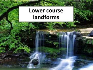
Lower course landforms. THE LOWER COURSE In the lower course, the river channel is wide and deep and is surrounded by a wide valley floor. The velocity of the river is greater as there is less friction with the river channel.

E N D
THE LOWER COURSE In the lower course, the river channel is wide and deep and is surrounded by a wide valley floor. The velocity of the river is greater as there is less friction with the river channel. The slopes of the valley and the gradient of the river channel are very gentle. Deposition is the main process operating in the lower course of a river. This is due to the river’s large load of eroded material (e.g. sand and silt) that it is carrying. However, there is still some lateral (sideways) erosion.
Video Rivers - oxbow lakes Duration: 00:55 http://www.bbc.co.uk/learningzone/clips/rivers-oxbow-lakes/405.html
KEY TERMS • Ox-bow lake - a lake formed when the continued narrowing of a meander neck results in the eventual cut through of the neck. • Meander scar - feature left behind when the water in an ox-bow lake dries up.
Formation of an oxbow lake • With continual erosion on the outside of the banks and deposition on the inside, the ends of the meander bend become closer. • Eventually due to the narrowing of the neck, the two outer bends meet and the river cuts through the neck of the meander, usually at times of flood. • The water now takes its shortest route rather than flowing around the bend. Deposition gradually seals off the old meander bend forming a new straighter river channel. • Due to continued deposition of alluvium the old meander bend is left isolated from the main channel as an ox-bow lake. TASK-Write the above steps along with the correct section of the diagram fig 20 page 70. Use colour to show deposition and erosion zones.
Overview of the Process • Start • Then • After • Finally The Formation of an Ox-Bow Lake
FLOODPLAINS AND LEVEES • A floodplain is the low flat area on either side of the river. It is found in the middle and lower course of the river. • When the river floods its banks, in times of heavy rainfall, it overspills to the surrounding land. As it moves out, the depth of the water reduces and friction with the land increases. The rivers energy decreases and it drops some of the load it is carrying (it drops the heaviest load first). • After a number of floods this sediment next to the banks builds up to create levees.