Download
1 / 31
320 likes | 586 Vues
Fronts: Structure and Observations. Fronts – Structure and Observations. Definition and Characteristics Definition Common Characteristics Frontal Slope Frontal Types Cold Fronts Warm Fronts Occluded Fronts Coastal Fronts Upper-Level Fronts. Definition and Structure.

E N D
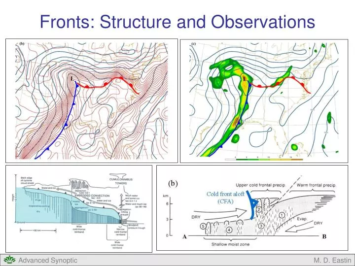
Fronts: Structure and Observations M. D. Eastin
Fronts – Structure and Observations • Definition and Characteristics • Definition • Common Characteristics • Frontal Slope • Frontal Types • Cold Fronts • Warm Fronts • Occluded Fronts • Coastal Fronts • Upper-Level Fronts M. D. Eastin
Definition and Structure • Definition: • Pronounced sloping transition zone between two air masses of different density • Disagreements and Caveats: • What defines an air mass? What defines a transition zone? • → Are we restricted to the synoptic-scale Bergeron air mass classifications? • → Do baroclinic zones induced by physical geography gradients count? • → Do drylines with minimal temperature gradients count? • → Must a density gradient of certain magnitude be present? Daytime Cloudy Cool Clear-Dry Warm → Do temperature gradients that “disappear” at night (or during the day) count as fronts? Nighttime Cloudy Cool Clear-Dry Cool M. D. Eastin
Definition and Structure • Our Definition: • In this course we will use a less restrictive definition of fronts as air mass boundaries • without certain gradient requirements throughout the diurnal cycle, but we will omit • those baroclinic zones mostly locked in place by topography (e.g., drylines) • Significance of Fronts: • Forecasts must account for frontal type, frontal movement, frontal intensity, • the spatialdistribution of clouds and precipitation, and the precipitation type • Frontal zones are pre-conditioned to support severe weather • Common Characteristics: • Enhanced horizontal gradients of density (temperature and/or moisture) • Relative minimum in pressure (a trough) • Relative maximum in cyclonic vertical vorticity (distinct wind shift) • Strong vertical wind shear (due to thermal wind balance) • Large static stability within the frontal zone • Ascending air with clouds / precipitation (moisture availability) • Greatest intensity near the surface (weaken aloft) • Shallow (1-5 km in depth) • Cross-front scale (~100 km) is much smaller than along-front scale (~1000 km) M. D. Eastin
Definition and Structure Surface Pressure Equivalent Potential Temperature (θe) Vertical Vorticity M. D. Eastin
Frontal Slope • How much does a front “slope” with height? • Let’s derive a simple equation that can describe • the vertical slope of any front • Assumptions • Front is oriented east-west • Only consider variations in “Y-Z space” • Neglect variations in the X direction • Density is discontinuous across the front • Pressure must be continuous so the PGF • remains finite (otherwise very strong winds) • Equation of state (p=ρRT), thus, requires • temperature to be discontinuous • Hydrostatic Balance • Geostrophic Balance • Pressure is steady (no changes in time) y ρc ρw x T ρ p Warm Cold y Front South North M. D. Eastin
Frontal Slope • The differential of pressure is: • (1) • Divide each side by Dy • (2) • Substitute in the hydrostatic equation • (3) • (4) M. D. Eastin
Frontal Slope • Since pressure is continuous across the front: • (5) • (6) • Substitution of (4) into (6) yields: • (7) • We can now solve for (Dz/Dy) • (8) M. D. Eastin
Frontal Slope • Which way can the front slope and still be “stable”? • The front must be able to persist for 1-2 days • (as fronts do in reality) • Thus (9) • And since (10) • Thus (11) • Or (12) • What does this imply about pressure across the front? z Stable ρw ρc y z Unstable ρc ρw y M. D. Eastin
Frontal Slope • What does this imply about pressure across the front? • While pressure is continuous across the front, the • pressure gradient is not continuous • Thus, the isobars must kinkto satisfy this relationship High pressure Or Low pressure High pressure M. D. Eastin
Frontal Slope • What can we say about the winds across the front? • Assume the flow is geostrophic across the front • and does not vary along the front: • (13) • Thus, on the warm and cold sides of the front: • (14) • Substituting (14) into (8) yields: • where (15) • Again, if and then or (16) • What does this imply about the winds across the front? M. D. Eastin
Frontal Slope • What does this imply about the winds across the front? • Recall the definition of geostrophic vertical vorticity • Thus, cyclonic vorticity must exist across the front • Here are more possible examples y ugc ugw x M. D. Eastin
Frontal Slope • How much does a front slope with height? • Returning to the frontal slope equation: • (15) • Using the Equation of State, (15) can be written as: • Margules Equation • for Frontal Slope • If we substitute in typical values: This is similar to observations! Surface fronts are shallow! M. D. Eastin
Frontal Slope • Similar conclusions can be reached for a front • oriented north-south using similar assumptions • Margules Equation • Again, frontal stability requires: • Thus, it can be shown: • The pressure gradient is discontinuous and the • isobars must kink across the front • The geostrophic wind must contain cyclonic • vorticity across the front y ρc ρw x T ρ p Cold Warm x Front West East M. D. Eastin
Frontal Slope • Synoptic-scale Vertical Motion: • The vertical motion immediately adjacent to a given • frontal slope can also be estimated: • where: v = cross-front velocity • c = the speed of the front • Example: • Dz/Dy ~ 1/300 • v ~ 5 m/s • c ~ 2 m/s • w ~ 0.01 m/s z ρw w v c ρc y This is similar to observations! Synoptic-scale vertical motions are weak! M. D. Eastin
Cold Fronts • Observational Aspects: • Cold air advances into a warmer air mass • Stereotypical passage includes: • Thunderstorms • Rapid (gusty) wind shift • Rapid temperature drop • Tremendous variability in weather ranging • from dry, cloud-free frontal passages to • heavy downpours with severe storms • Variability related to the cold front’s spatial • orientation relative to the warm-conveyor • belt ahead of the cold front • Katafront → Precipitation ahead of the • surface front • Anafront → Precipitation along / behind • the surface front M. D. Eastin
Cold Fronts • Observational Aspects: Katafronts • Warm conveyor belt parallel to surface front • Limited lift along the surface front • Most lift associated with an elevated surge • of cold-dry air above the surface front, often • called a cold front aloft (CFA) • Occur later in the parent cyclone’s lifecycle • (when the cold front has a N-S orientation) B A A B • Warm front precipitation • Convection cells ahead of CFA • Precipitation from CFA falling • in warm conveyor belt • Shallow warm-moist zone • Surface front (light precipitation) M. D. Eastin
Cold Fronts • Observational Aspects: Anafronts • Warm conveyor belt crosses • the surface front at some angle • Significant lift along surface front • Often accompanied by a southerly • low-level jet just ahead of the • surface frontal zone • Increased risk of winter precipitation • during the cold season • Tend to occur earlier in the parent • cyclone’s lifecycle (when the cold • front has greater E-W orientation) M. D. Eastin
Cold Fronts • Observational Aspects: Arctic Cold Fronts • Second surge of cold air • Very shallow • Strong temperature gradient • Often lack precipitation • Behind primary cold front • Behind false warm sector Arctic Cold Front Primary Cold Front M. D. Eastin
Cold Fronts • Observational Aspects: Back-door Cold Fronts • Caused by differential • cross-front advection • along a pre-existing • warm/stationary front • Surge of near-surface • cold air originating • over a cold surface • moves south/southeast • Most common along the • U.S. East coast • Don’t assume all cold • fronts move southeast!!! Back-door Cold Front M. D. Eastin
Warm Fronts • Observational Aspects: • Warm air advances into a colder air mass • Motion is slow than cold fronts → dependent upon turbulent mixing along stable boundary • Warm fronts often have shallow slopes → the pressure trough is weaker • (makes warm fronts difficult to analyze) • Low clouds / stratiform precipitation common • Deep convection less common FFC M. D. Eastin
Warm Fronts • Observational Aspects: Back-door Warm Fronts • Warm air advances into a colder air mass • Importance of source region → maritime polar air is warmer than continental polar air • Don’t assume warm fronts always move north!!! M. D. Eastin
Occluded Fronts • Observational Aspects: • When “a fast-moving cold front overtakes a slow-moving warm front from the west” • Cyclone become cut-off from the warm sector → baroclinic instability ends • Marks the mature stage of a midlatitude cyclone → dissipation ensues • Rising motion above the frontal zone is weak as warm air lifted over cool/cold air • Stratiform precipitation is the norm M. D. Eastin
Occluded Fronts Observational Aspects: Two Conceptual Models • Norwegian Cyclone Model • Initial cyclone development from a stationary front • Cold front advances and “overtakes” warm front • Cyclone near peak intensity as “occlusion” starts • Extension of the occluded front is southward • Shapiro-Keyser Cyclone Model • Initial cyclone development from a stationary front • Fast-moving cold front “fractures” • A “bent back” warm front (develops) • As cold front surge continues, warm air becomes • “secluded” (or occluded) from cyclone center M. D. Eastin
Occluded Fronts • Observational Aspects: Two Occlusion Types • Depend on the relative temperature of • the pre- and post-frontal air masses • Cold occlusions should be much more • common in the eastern US → Why? • Warm occlusions are much more • common in western Europe → Why? • (and have been studied more) • Completion of your homework will provide • a new perspective to all this “conventional • wisdom” regarding occluded fronts! M. D. Eastin
Coastal Fronts • Observational Aspects: • Strong temperature contrast caused • by warm-moist maritime air adjacent • to cold-dry continental air • Temperature differences of 5°-10°C often • occur over distances of 5-10 km • Shallow (less than 1 km deep) • Occur during the cold season (Nov-Mar) • Form along concave coastlines • (New England, Carolinas, Texas) • Cross-front structure similar to warm front • Pressure field often an “inverted trough” • Heaviest precipitation on “cold side” • Often the boundary between rain and • frozen precipitation types • Can serve as a primary or secondary site • for cyclogenesis M. D. Eastin
Coastal Fronts • Observational Aspects: Formation • Cold anticyclone north or northeast • of frontal location → onshore flow • Onshore flow acquires heat / moisture • via strong surface fluxes from relatively • warm offshore waters (Gulf Stream) • Differential friction at coastline causes • distinct wind shift that favors frontal • formation along the coastline • Can be enhanced by cold-air damming • events along the Appalachians • Can be enhanced by a land breeze M. D. Eastin
Coastal Fronts Observational Aspects: Motion Onshore migration → anticyclonic shifts eastward → geostrophic wind intensifies or primarily onshore Offshore migration → anticyclonic shifts northward → geostrophic wind weakens or primarily along-shore M. D. Eastin
Upper-Level Fronts Observational Aspects: • Sharp thermal gradients in the upper/middle troposphere → don’t extend to the surface • Associated with “tropopause folds” whereby stratospheric air is drawn down into the troposphere → subsidence due to ageostrophic flow near jet streaks (right-exit region) → subsidence produces adiabatic warming (thermal front) → subsidence leads to vortex stretching (pocket of high PV) Isentropes (solid) Isotachs (dashed) Potential Vorticity (solid) Jet Core Jet Core Subsidence Tropopause Upper-level Front M. D. Eastin
Upper-Level Fronts Observational Aspects: Significance • Have little to no impact on synoptic or mesoscale weather • Regions of strong clear air turbulence → significant hazard to aircraft • Regions of mixing between the troposphere and stratosphere • Transport → Radioactivity downward • → Ozone downward • → CFCs upward B A A B M. D. Eastin
References Bluestein, H. B, 1993: Synoptic-Dynamic Meteorology in Midlatitudes. Volume II: Observations and Theory of Weather Systems. Oxford University Press, New York, 594 pp. Bosart, L. F., 1985: Mid-tropospheric frontogenesis. Quart. J. Roy. Meteor. Soc., 96, 442-471. Lackmann, G., 2011: Mid-latitude Synoptic Meteorology – Dynamics, Analysis and Forecasting, AMS, 343 pp. Miller, J. E., 1948: On the concept of frontogenesis. J. Meteor., 5, 169-171. Newton, C. W., 1954: Frontogenesis and frontolysis as a three-dimensional process. J. Meteor., 11, 449-461. Petterssen, S., 1936: A contribution to the theory of frontogenesis. Geopys. Publ., 11, 1-27. Sanders, F., 1955: An investigation of the structure and dynamics of an intense surface frontal zone. J. Meteor, 12, 542-552. Schultz, D. M., and C. F. Mass, 1993: The occlusion process in a midlatitude cyclone over land, Mon. Wea. Rev., 121, 918-940. Shapiro, M. A., 1980: Turbulent mixing within tropopause folds as mechanisms for the exchange of chemical constituents between the stratosphere and troposphere. J. Atmos. Sci., 37, 995-1004. Shapiro, M. A., 1984: Meteorological tower measurements of a surface cold front. Mon. Wea. Rev., 112, 1634-1639. M. D. Eastin