Download
1 / 13
170 likes | 537 Vues
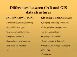
CAD vs. GIS. Fabian Guerrero 10/2007. What is the difference between Graphical Interface Systems (GIS) and Computer Aided Drafting (CAD) anyway?. Overview:. GIS Description GIS Examples GIS File Extensions CAD Description CAD Examples CAD Estensions Data Layers Model Summary Conclusion

E N D
CAD vs. GIS Fabian Guerrero 10/2007
What is the difference between Graphical Interface Systems (GIS) and Computer Aided Drafting (CAD) anyway?
Overview: • GIS Description • GIS Examples • GIS File Extensions • CAD Description • CAD Examples • CAD Estensions • Data Layers Model • Summary • Conclusion • Questions?
GIS Description: • GIS is a computer system capable of capturing (when paired with a GPS), storing, analyzing, and displaying geographically referenced information • The power of a GIS comes from the ability to relate different information in a spatial context and to reach a conclusion about this relationship USGS: Graphical Information Systems (2007) Retrieved 9, October 2007, Web site: http://erg.usgs.gov/isb/pubs/gis_poster/
GIS Examples: This vector data model represents real-world features as points, lines, and polygons whose boundaries are defined by x,y coordinate pairs.
GIS File Extensions: Allowable Extensions: Reserved Extensions: .bil .mxd .bip .mxt .bmp .ntf .bsq .ovr .dbf .png .dt1 .prj .ers .raw .fdb .sbn .gdb .sbx .gif .shp .gis .shx .img .sid .jpg .stk .lan .sxd .lgg .tif .loc .txt .lyr .xml .mdb • eps • ers • exe • fbt • fbx • fls • ftg • fts • gen • gfw • gif • hdr • hlp • htm • html • ico • idx • img • ini • ixc • ixs • jpg • key • lin • lnk • mat • mcp • mdf • mid • mif • mrk • mxc • mxs • nit • ndx • nls • odb • odb • pat • pdf • pif • pps • prj • ps • rlc • rs • sbn • sbx • shd • shp • shx • stn • tab • tbl • tif • tfw • tmp • ttf • txt • xbm • wmf • wld • wri
CAD Description: • CAD software is used to create precision drawings or technical illustrations. CAD software can be used to create two-dimensional (2-D) drawings or three-dimensional (3-D) models. • Often partnered with a CAM (Computer Aided Machine) or Mill for precision fabrication. Whatis?com: Definitions – What is CAD (2007) Retrieved 29-October, 2007 Web site: http://whatis.techtarget.com/sDefinition/0,,sid9_gci211732,00.html
CAD Examples: These CAD drawings illustrate how lines are layered to create a precision “how-to” in a referenced space. At left is a 3-D model rendering of a motorcycle.
CAD File Extensions: .dwg .dws .dwt .dxf .exe .fas .fdc .fmp .hdi .hlp .las .lin .lli .lsp .mli .mnc .mnl .mnr .mns .mnu .pat .pc3 .pgp .pmp .pss .scr .shp .shx .slb .sv$ .stb .unt .xml .xtp
Summary: The difference between CAD and GIS systems is becoming blurred with the internal attributes and database linkages enhancing CAD’s capabilities.
Conclusion: GIS is a database program, and CAD is a graphics program. With CAD, it's the lines that are important, i.e. the drawing is the information. With GIS, the lines are just a representation of the data behind it.
Questions ? Thank You!!