Download
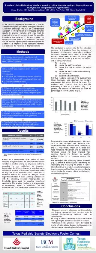
1 / 2
20 likes | 121 Vues
Texas Geographic Society. The mission of the Texas Geographic Society (TXGS) is to unite public, private and nonprofit resources to improve government, education, and other public services through shared development and use of digital geographic data and related technologies. PROJECTS.

E N D
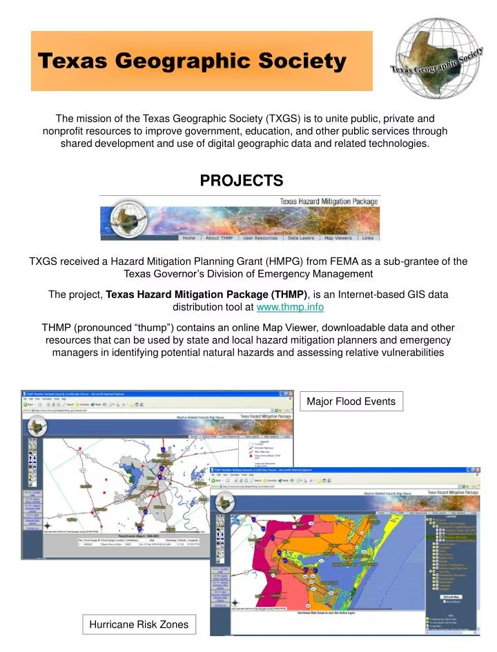
Texas Geographic Society The mission of the Texas Geographic Society (TXGS) is to unite public, private and nonprofit resources to improve government, education, and other public services through shared development and use of digital geographic data and related technologies. PROJECTS TXGS received a Hazard Mitigation Planning Grant (HMPG) from FEMA as a sub-grantee of the Texas Governor’s Division of Emergency Management The project, Texas Hazard Mitigation Package (THMP), is an Internet-based GIS data distribution tool at www.thmp.info THMP (pronounced “thump”) contains an online Map Viewer, downloadable data and other resources that can be used by state and local hazard mitigation planners and emergency managers in identifying potential natural hazards and assessing relative vulnerabilities Major Flood Events Hurricane Risk Zones
THMP currently contains over 60 GIS data layers in 11 hazard categories, including Hurricanes/Tropical Storms, Tornadoes, Floods, Other Storms, Drought, Outdoor Fires Extreme Temperatures, Coastal Erosion, Earthquakes, Hazardous Materials and Subsidence Population Vulnerability to Floods THMP also contains maps and data on Population Vulnerability and Property Value Vulnerability to various hazards in order to determine relative vulnerability and what might be investigated further for emergency response or mitigation planning purposes Summary: www.thmp.info • THMP is free, easy-to-use, and you already have it! • Use THMP Map Viewer to identify and provide necessary data and maps for mitigation plans and other related risk assessment activities • Use THMP to download data into your own GIS/mapping system to support or initiate your specific projects • Use THMP Map Viewer for preliminary investigation of vulnerable areas to analyze in HAZUS OUTREACH & TRAINING The Texas Geographic Society (TXGS) is committed to educating Texans about the use and benefits of THMP and other hazard-related tools, including HAZUS-MH, an application from FEMA • HAZUS-MH is a planning tool that estimates damage and • losses from natural hazards (Flood, Hurricane and Earthquake) • It also assesses population needs and allows users to • compare scenarios involving mitigation techniques • It can be used in conjunction with THMP, whereby hazard identification and preliminary investigation was performed TXGS offers the unique feature of a mobile training lab to conduct on-site computer-based instruction to THMP and HAZUS-MH users. We may also conduct training at your facility or in conjunction with an event. Currently, training is provided free or at a very minimal cost. Contact Info: Craig Eissler at 512-912-9695 or craig@texasgs.org OR Roddy Seekins at 512-507-8515 or roddy@texasgs.org