Download
1 / 39
390 likes | 530 Vues
Iowa Spring Flood Outlook. March 5, 2010 Jeff Zogg, Senior Hydrologist. Topics. Outlook at-a-glance Definitions Current conditions Latest spring food outlook Questions. Outlook at-a-glance.

E N D
Iowa Spring Flood Outlook March 5, 2010 Jeff Zogg, Senior Hydrologist
Topics • Outlook at-a-glance • Definitions • Current conditions • Latest spring food outlook • Questions
Outlook at-a-glance • High risk of significant flooding continues in many areas. Has gone even higher in the Des Moines River basin above Saylorville Reservoir. • Highest risk areas include the Des Moines, Raccoon and Little Sioux River basins, as well as the Mississippi River from Davenport downstream and including its tributaries. • At least near to above normal risk of flooding statewide. • Time period when flooding is most likely extends from the middle third of March into late April for most streams. • Slightly later for the Mississippi and Missouri Rivers.
Outlook at-a-glance • Above normal risk of flash flooding especially from ice jams. • Ice jam flooding is not included in this outlook. • Risk of flooding and flash flooding will be higher than normal after the snow melts. • Will remain higher than normal at least into late spring.
Definitions • Stage / Gage height • The level of the water surface of a stream above an established datum at a given location. The established datum may be a local elevation or sea level. • Reach • A section of stream between an upstream and downstream location, for which the stage or flow measured at a point somewhere along the section (e.g., gaging station or forecast point) is representative of conditions in that section of river or stream.
Definitions • Bankfull stage • An established gage height at a given location, above which a rise in water surface will cause the river or stream to overflow the river bank somewhere in the corresponding reach. • Flood stage • An established gage height for a given location at which a rise in water surface level begins to create a hazard to lives, property or commerce. The issuance of flood (or in some cases flash flood) warnings is linked to flood stage. Not necessarily the same as bankfull stage.
Definitions • Minor flooding • Minimal or no property damage, but possibly some public threat. • Moderate flooding • Some inundation of structures and roads near stream. Some evacuations of people and/or transfer of property to higher elevations. • Major flooding • Extensive inundation of structures and roads. Significant evacuations of people and/or transfer of property to higher elevations.
Definitions • Record flooding • Flooding which equals or exceeds the highest stage or discharge observed at a given site during the period of record keeping. The highest stage on record is not necessarily above the other three flood categories – it may be within any of them or even less than the lowest. Stage – flood category relationship
Stream levels—now 14-day average flow
Ground frost Observed frost depth
Soil moisture—now Soil moisture percentiles Percentile key ~1: near record low <10: much below normal 10 -24: below normal 25-75: normal 76-90: above normal >90: much above normal ~99: near record high
Soil moisture—recent Soil moisture percentiles—December 2009 Percentile key ~1: near record low <10: much below normal 10 -24: below normal 25-75: normal 76-90: above normal >90: much above normal ~99: near record high
Assumptions / notes • This outlook is biased toward normal temperatures and precipitation (i.e., climatology) during the outlook period. • If conditions are not near normal then the probabilities in this outlook may not be valid. • Ice jams • This outlook does not take into account flooding from ice jams. Flooding from ice jams would be above and beyond the flooding potential indicated in this outlook.
Risk of minor flooding—now West 1/3 of Iowa (Missouri River basin) East 2/3 of Iowa (Mississippi River basin)
Risk of minor flooding—second outlook West 1/3 of Iowa (Missouri River basin) East 2/3 of Iowa (Mississippi River basin)
Risk of moderate flooding—now West 1/3 of Iowa (Missouri River basin) East 2/3 of Iowa (Mississippi River basin)
Risk of moderate flooding—second outlook West 1/3 of Iowa (Missouri River basin) East 2/3 of Iowa (Mississippi River basin)
Risk of major flooding—now West 1/3 of Iowa (Missouri River basin) East 2/3 of Iowa (Mississippi River basin)
Risk of major flooding—second outlook West 1/3 of Iowa (Missouri River basin) East 2/3 of Iowa (Mississippi River basin)
Final thoughts • Most homeowners’ insurance policies do not cover flood-related losses. • To cover flood-related losses, flood insurance must typically be purchased. This is in addition to homeowners insurance. • Disaster assistance, if it’s available, is typically a loan that you must repay with interest. • In most cases, flood insurance requires a 30-day waiting period before it becomes effective. • Visit http://www.floodsmart.gov/ for more information.
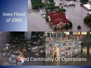
Final thoughts • Will we see another “2008”? • A big factor in 2008 was the heavy rainfall from May-June. • High-end events such as the 2008 floods typically result from a sequence of additive factors. While one factor by itself may not lead to a high-end event, the combination of factors elevates the risk of a high-end event. • Factors which contribute to significant flooding this spring are lining up. • This does NOT automatically mean that we’ll have a repeat of 2008 though. We could luck out this spring—the flooding may be less severe than our outlook indicates.
Final thoughts • Spring flood outlook schedule • 1st Outlook: Friday, January 29, 2010. • 2nd Outlook: Friday, February 19, 2010. • 3rd Outlook: Friday, March 5, 2010. • 4th Outlook (Optional): Friday, March 26, 2010.
Questions Contact information: jeff.zogg@noaa.gov 515-270-4501 http://www.weather.gov/desmoines