Download
1 / 8
80 likes | 177 Vues
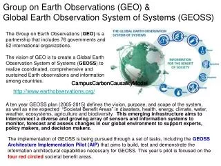
Metadata Needs for Global Earth Observations. System of Registries Conference Washington, DC May 20, 2009 Steve Young Senior Advisor, EPA Office of Environmental Information. Background on Global Earth Observations. What is the Global Earth Observation System of Systems (GEOSS)?

E N D
Metadata Needs for GlobalEarth Observations System of Registries Conference Washington, DC May 20, 2009 Steve Young Senior Advisor, EPA Office of Environmental Information
Background on Global Earth Observations • What is the Global Earth Observation System of Systems (GEOSS)? • What kinds of data are included in the GEOSS scope? • What challenges do GEOSS data introduce? • Visualizing the Earth and humanity as a total system • So what, who cares?
(Modeling) Value-added products, e.g. Indicators Assessments Plans etc. Earth System Models Weather Climate Atmosphere Others… Predictions Execute actions and practice adaptive management Policy Decisions Decision Support Societal Benefits Management Decisions DATA E.g. Climate Energy Water Air quality Human Health Disaster response Agriculture Ecosystems Earth Observation Systems Remotely-sensed In situ Personal Decisions Decision support tools Observations (Monitoring) On-going feedback to optimize value and reduce gaps Linking Earth Observations to Societal Benefits (IEOS Strategic Plan, p. 17 Figure1) IEOS = Integrated Earth Observation System
Service-Oriented Architecture Approach for Monitoring, Modeling, Decisions Monitoring/Observation Services Earth Systems – The Environment Sensor(s) Sensor services Data collection/logging svcs Data storage and management svcs Data access/publishing services Modeling Services Data ingest services Model services (may be chained) Post-processing services (e.g. regridding, analytics/statistics, visualization) Metadata! Outcomes, Societal Benefits Decision Support Services Decision implementation/ Action Execution/ Adaptive Management svcs Value-added product development services (aids to decision-makers) Simulation/trade-off analysis services
GEOSS Metadata Challenges • Highly diverse data: air, water, land, biota, etc. • Multiple types, multiple sources, multiple providers • Novel data for many, highly diverse users • Model outputs as well as observation data sets • Multi-media, multidisciplinary: Terminology(ies)!
Metadata approach • Cover the basics: who, what, when, where, why, how • Use standards (but which?) Simple is better… • Address the derived products issues: need to be able to reproduce results which means get back to archived source data, chain of custody/provenance of processing services performed on data, “service chain” • User desire for a “drill-down” environment that starts out high-level and supports drilling down to successive layers of greater detail on demand
Questions • What are the right standards? • How do we increase nimbleness/agility etc. – should it be an “ecosystem of systems”? • How does it work in a service-oriented environment? • Terminologies: taxonomies, ontologies, controlled vocabularies… • User input and feedback • The role of citizen science • How does knowledge or know-how fit into the picture? Wikis? Should there be a “Knowledge Registry”?
Thanks! Steve Young Young.Steve@epa.gov