Download
1 / 7
70 likes | 192 Vues
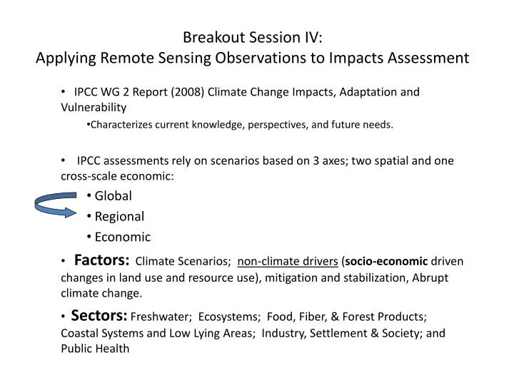
Breakout Session IV: Applying Remote Sensing Observations to Impacts Assessment. IPCC WG 2 Report (2008) Climate Change Impacts, Adaptation and Vulnerability Characterizes current knowledge, perspectives, and future needs.

E N D
Breakout Session IV:Applying Remote Sensing Observations to Impacts Assessment IPCC WG 2 Report (2008) Climate Change Impacts, Adaptation and Vulnerability Characterizes current knowledge, perspectives, and future needs. IPCC assessments rely on scenarios based on 3 axes; two spatial and one cross-scale economic: Global Regional Economic Factors: Climate Scenarios; non-climate drivers (socio-economic driven changes in land use and resource use), mitigation and stabilization, Abrupt climate change. Sectors: Freshwater; Ecosystems; Food, Fiber, & Forest Products; Coastal Systems and Low Lying Areas; Industry, Settlement & Society; and Public Health
Breakout Session IV:Applying Remote Sensing Observations to Impacts Assessment • IPCC WG2 Future Research Needs • Climate Modeling that elucidates the nature of future changes at regional scale. • Especially precipitation, hydrological consequences. • Understanding regional effects of abrupt climate change events. • Monitoring: Long-term field data collection on managed and un-managed systems and human activities. (Can remote sensing data augment this activity?) • Ability to integrate multiple stressors for vulnerability assessment. • Adaptation to environmental changes • Costs of adaptation/mitigation
Breakout Session IV:Applying Remote Sensing Observations to Impact Assessment • Remotely sensed observations should support efforts that bridge global and regional scales • Climate modeling – regional manifestation of changes • Abrupt climate change scenarios – regional manifestations. • Long-term field data collection that includes managed and un-managed systems and human activities.
Breakout Session IV:Applying Remote Sensing Observations to Impacts Assessment • Current missions provide a wide range of relevant data. • Research should be steered to use these data in relevant regional scale modeling efforts. • Spatial resolution: Are multi-kilometer scale, 1km, 500m, 250m resolutions adequate? • Cross-platform data integration needed (including non-NASA data) to link processes. What platforms/sensors should be grouped?
Questions to be addressed • What research can we conduct to better address the impacts and consequences of global change? • What actions would be most useful to or supportive of future assessments? • What are the greatest challenges and opportunities relevant to the use of remote sensing data for impacts assessment?
Breakout Session IV:Applying Remote Sensing Observations to Impacts Assessment • Current NASA Missions • Terra • Aqua • Aura • TRMM • ICESAT • QUICKSCAT • Calipso • Cloudsat • GRACE • JASON • EO-1
Breakout Session IV:Applying Remote Sensing Observations to Impacts Assessment • Planned Missions: • NPP/NPOESS • SMAP • OCO • Landsat • ACE • AQUARIUS • GLORY • ICESAT