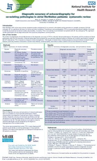
Download
1 / 30
300 likes | 430 Vues
1. Innovation Collaboration/ Integration and GEOSS Technology transfer Intercomparisons Quality management Disaster Preparedness and Mitigation. Instruments and Methods of Observation Programme - SUMMARY. 2. World Meteorological Organization. WWW/IO/TECO-2006. 1. Innovation

E N D
1. Innovation Collaboration/ Integration and GEOSS Technology transfer Intercomparisons Quality management Disaster Preparedness and Mitigation Instruments and Methods of Observation Programme - SUMMARY 2 World Meteorological Organization WWW/IO/TECO-2006
1. Innovation Collaboration/ Integration and GEOSS Technology transfer Intercomparisons Quality management Disaster Preparedness and Mitigation Automation Interoperability Composite networks Tiered networks Adaptive observations Rebalancing networks Data assimilation Instruments and Methods of Observation Programme 3 World Meteorological Organization WWW/IO/TECO-2006
1a. Automation An increasing uptake of AWOS particularly with “advanced” sensors that measure those elements traditionally observed by humans. Continued development in present weather sensors, including video cameras can only make these systems more appealing to Members. Greater uptake by Members of automatic launch systems and remote sensing. Cooperative development between NMHSs, HMEI and manufacturers is of benefit to all parties, e.g. the introduction of the Vaisala Autosonde within Australia. 4 World Meteorological Organization WWW/IO/TECO-2006
1b. Interoperability Development of an upper air system to utilize various types of radiosondes may allow Members greater flexibility with their National Programs, e.g. Dars-es-Salaam (2004) Interoperability developed into their Radiosonde Replacement System by the USA NWS. Standardization through CIMO’s collaboration with CBS through their ET on Requirements for data from AWS 5 World Meteorological Organization WWW/IO/TECO-2006
1c. Composite networks GLOBAL composite Upper Air networks, gaining more acceptance – wind profilers, radiosondes, AMDAR, satellite, GPS water vapour AMDAR improvements have seen valuable ascent, descent and cruise-level datum made available to Members – not fully integrated Continuing efforts of ETs and OPAGs to encourage the development of research systems into operational systems. 6 World Meteorological Organization WWW/IO/TECO-2006
1d. Tiered networks The incorporation of a network of observing sites of varying complexity and instrumentation with consistent training for all support staff. The use of redundant sensors to facilitate less uncertainty for data Quality and greater stability for operations. This also allows NMHSs greater flexibility in their maintenance regimes which can lead to efficiencies. The use of well-trained, voluntary staff to supplement the NMHSs staffed sites. 7 World Meteorological Organization WWW/IO/TECO-2006
1e. Adaptive observations Observations are performed for key National imperatives – usually forecasts and warnings. This may supplant a National reduction of previously scheduled observations, e.g. Australian 12 UTC radiosonde network The use of additional observations and/or additional value-added input at key National or International significance, e.g. cyclone/ hurricane/typhoon. 1f. Rebalancing networks The review of their networks by NMHSs to ensure that goals and outputs are met, e.g. UK Met Office and Australian Bureau of Meteorology. 8 World Meteorological Organization WWW/IO/TECO-2006
1g. Data Assimilation Greater assimilation of satellite and surface-based data into more sophisticated numerical models has improved forecasting for weather, climate and hydrology. NMHSs need to carefully balance real-time data requirements with that of long-term climatological requirements. Allowing for biases introduced by new technology complicates the detection of climate change and as such metadata becomes increasingly important. CIMO recommends detailed metadata information be part of the overall NMHS’s quality management system[i]. 9 World Meteorological Organization WWW/IO/TECO-2006
1g. Data Assimilation (cont) Many NMHSs are cooperatively developing high-end systems in conjunction with their meteorological field editing. A key component of data assimilation is the use by NMHSs of comparative data as a quality management and assurance tool for various systems. Therefore CIMO has a key role in determining key user requirements and standards for satellite calibration as this will have a critical impact on the Global Observing System. [i] Developments in a Modern Quality Management System: Observations Quality Control Network Performance and METADATA Database, R.P. Canterford, D. K. Evans, L. Allen (TECO 2000) 10 World Meteorological Organization WWW/IO/TECO-2006
2. Collaboration/ Integration and GEOSS 11 World Meteorological Organization WWW/IO/TECO-2006
CIMO provides cooperation, encouragement and assistance to HMEI to develop instruments that better suit NMHSs. There has been increasing cooperation between NMHSs with a number of jointly operated networks and cooperative research projects taking place eg EUMETNET; CWINDE; EUCOS; PRISM; THORPEX. The cooperative organisation of WMO technical conference TECO-2002 and the conjointly organized exhibition METEOREX-2002 in Slovakia in September 2002 allowed greater appreciation of each community’s requirements and expectations. TECO and METEOREX 2005 Romania Collaboration between CIMO and the Chinese Meteorological Agency, has seen the production of the Instrument Catalogue. 2. Collaboration/Integration 12 World Meteorological Organization WWW/IO/TECO-2006
CIMO will specifically contribute to GEOSS activities through: • determine additional siting standards for different programs; • interact with instrument manufacturers in establishing performance specifications for systems operating in harsh environments; • develop guidelines for the switch from manual to automatic surface observations; • review AMDAR water vapour comparisons, including an intercomparison of new generation equipment; • expertise on standardization procedures; • Examine developing standards for ground-based GPS • intercomparisons to ensure instrument compatibility and data homogeneity; and • coordination of RICs and RRCs to ensure traceability. 2c. GEOSS 13 World Meteorological Organization WWW/IO/TECO-2006
3. Technology transfer 14 World Meteorological Organization WWW/IO/TECO-2006
3a. Training • Training Workshop on Metrology for RICs • Trappes, France, October 2005 • Training Workshop on Metrology for RA VI • Ljubljana, Slovenia, April 2006 • Training Workshop on Metrology for RA VI • Bratislava, Slovakia, April 2006 • Training Workshop on Metrology for RA I • Cairo, Egypt, April 2006 • Training Workshop on Upper Air Observations for • RA III Buenos Aires, Argentina, May 2006 15 World Meteorological Organization WWW/IO/TECO-2006
3b. Documentation – CIMO Guide • 42 experts from 17 countries have • worked on the update of the CIMO • Guide since 2002 • 32 chapters updated plus 2 new • chapters included • Preliminary issue (in English) • published in May 2006 • Final approval by CIMO-XIV 16 World Meteorological Organization WWW/IO/TECO-2006
3b. Documentation – IOM Reports 17 World Meteorological Organization WWW/IO/TECO-2006
3b. Documentation • Instrument Development Inquiry Reports • Now reached 7th edition • Important for technology transfer • Regularly published as IMOP reports • Instrument Catalogue • Assistance from the China Meteorological • Administration • List of instruments and manufacturers • Allows users to make informed choices 18 World Meteorological Organization WWW/IO/TECO-2006
4. Intercomparisons 19 World Meteorological Organization WWW/IO/TECO-2006
4a. Intercomparison of HQ RSO • Results: • Error characteristics of HQ RSO • Systems • Improved accuracy of HQ RSO • Systems • Usefulness of geopotential height • derived from the geometric height • measured by GPS RSO • Best combination of RSO for • “reference” purposes 20 World Meteorological Organization WWW/IO/TECO-2006
4b. IPC-X / RPCs • Main Objectives: • Dissemination of the WRR to ensure • worldwide homogeneity of solar • radiation measurements • Training to RRCs & NRCs, • especially from developing countries • Symposium on solar radiation • measurements 21 World Meteorological Organization WWW/IO/TECO-2006
4c. Laboratory. Intercomparison of RI Gauges • Laboratories: • Météo France, Trappes • KNMI, De Bilt • Italian Met. Service/University of Genoa • Instruments: • 19 pairs from 18 Manufacturers • Testing Period: • 1st Phase: 15 Sep 04 - 15 Feb 05 • 2nd Phase: 15 Feb 05 - 15 May 05 • 3rd Phase: 15 May 05 – 30 Sep 05 22 World Meteorological Organization WWW/IO/TECO-2006
5. Quality management 23 World Meteorological Organization WWW/IO/TECO-2006
42 experts from 187 countries have worked on the update of the CIMO Guide since 2002. • 32 chapters updated plus 2 new chapters included • Preliminary issue (in English) published in May 2006. • Final approval by CIMO-XIV 5a. CIMO Guide 7th Edition 24 World Meteorological Organization WWW/IO/TECO-2006
Main Objectives: • Discuss options for improving the • functionality of RICs; • Review, revise as needed, and approve • TORs; and • Prepare a strategy for strengthening the • services of RICs. • The ET proposed recommendations to be submitted for consideration by CIMO-XIV. 5b. ET-RC, QMS & CIMO-XIV 25 World Meteorological Organization WWW/IO/TECO-2006
6. Disaster Preparedness and Mitigation 26 World Meteorological Organization WWW/IO/TECO-2006
These have been innovations in the development of instruments for extreme conditions. These innovations have included: • instrumentation and sensors such as anemometers and humidity probes for alpine environments; • AWOS electronics and sensors for extreme tropical cyclone, hurricane or typhoon wind; and • pressure measurements and rainfall intensity instruments for measuring major rainfall events for flood predictions and drought environments at the other end of the scale. 6. Disaster Preparedness and Mitigation 27 World Meteorological Organization WWW/IO/TECO-2006
6. Disaster Preparedness and Mitigation Innovation has also been demonstrated recently by the integration of enhanced tsunami warning/monitoring networks following the tragic tsunami off the coast of Aceh, Indonesia in December 2004. Several countries are purchasing and installing tsunami sea level instruments and deep ocean tsunami monitoring buoys to put in place detection and warning networks for this hazard. Many NHMS are becoming involved with this type of instruments and the sharing of data. Significant effort has been directed into both the design of coastal and deep ocean networks that will provide the maximum possible warning time for affected countries. At the same time there has been investigation of the sampling protocols needed for rapid and accurate detection of tsunami. This includes sampling frequencies, reporting frequencies and metrology. 28 World Meteorological Organization WWW/IO/TECO-2006
Since the devastating tsunami of December 2004 a great deal has come to light about the science of tsunami and it has become apparent that there is a lot more to learn in terms of appropriate instruments and methods of sharing data for which CIMO, in collaboration with JCOMM, will be able to provide assistance. Most of the existing networks have been designed for monitoring of long period phenomenon, such as tides and climate change. These networks and instruments in general cannot accurately characterize the tsunami events and are often located in harbours that complicate the detection and wave characteristics. Significant effort is going into development of siting procedures with a specific focus on medium period phenomenon such as tsunami. There are also significant developments in measurement technologies for detection of tsunami. Australia is planning to carryout an initial intercomparison of some of the viable coastal sea-level technologies to determine their suitability for use for tsunami detection[i]. This will include assessment of calibration methods and traceability. [i] Personal communication, J. O. Warne, Australian Bureau of Meteorology 6. Disaster Preparedness and Mitigation 29 World Meteorological Organization WWW/IO/TECO-2006
6. Disaster Preparedness and Mitigation • Overall, CIMO has a critical role in innovation of measurements and observation techniques for disaster preparedness and mitigation, and assists WMO in the Disaster Preparedness and Mitigation (DPM) Programme through the provision of: • Instrument specifications and observing systems to meet requirements for the accurate and traceable measurement of meteorological, related geophysical and environmental variables, taking into account both experience and new developments for hazard monitoring and detection; • Encouragement to the instrument manufacturers to develop more robust instruments with greater resilience to extreme weather conditions and with increased measuring ranges; • Guidance on the use of instruments in harsh conditions]. [i] Progress report on the activities of the CIMO coordinator for DPM Programme, R. Dombrowsky - CIMO-XIV