Download
1 / 12

E N D
Coherent Doppler Lidar Roadmap to Both the NRC Decadal Survey “Science Demonstration” and “Operational” MissionsMichael J. KavayaJirong YuUpendra SinghNASA Langley Research Centermichael.j.kavaya@nasa.govMulugeta PetrosScience and Technology Corp.Working Group on Space-Based Lidar WindsMonterey, California USA5 – 8 February 2008
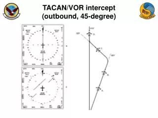
Geometry400 vs. 824 km45 degree nadir angleSpherical earth 400 – 48.5 s/350 km 824 – 53.1 s/350 km
Pulsed Doppler Wind Lidar Concept Science Mission Operational Mission NRC 2007 Earth Science Decadal Survey Recommended Demonstration “3-D Winds” Mission in 2016 NRC 2007 Earth Science Decadal Survey Recommended Operational “3-D Winds” Mission in 2022
NASA/NOAA 2008Wind Measurement Requirements Science Demonstration Mission Current Horizontal Wind Vertical Profile Observations ~23 km • Global averages • If 2 measurements in a box, pick best one • Emphasis on wind profiles vs. height Operational Mission Courtesy Dr. G. David Emmitt Note different color key
Connecting Lidar Parameters to Measurement Performance Coherent Detection Doppler Wind Lidar • Equal Performance Parameter Linkages: • Note: better vertical resolution is a smaller value of “Vert Res” • If decrease (improve) Vert Res by a factor F, then increase E by a factor , or increase PRF by F, or increase D by • If increase number of azimuth angles NAZ by a factor F, then increase PRF by F, or increase Vert Res by F, or increase E by , or increase D by • If increase R by a factor F, then increase D by F, or increase E by F2, or increase PRF or Vert Res by F4
Coherent Doppler Lidar Roadmap to Hybrid DWL Science and Operational Missions: Science Demonstration, 400 km Point Design With Requirements Exceeded Most desirable Least desirable *assume no SNR loss due to scanner effective aperture **Does not include spare lasers for each lidar
Coherent Doppler Lidar Roadmap to Hybrid DWL Science and Operational Missions: Operational, 400 km Note: 250 mJ x 2 = 500 mJ *assume no SNR loss due to scanner effective aperture **Does not include spare lasers for each lidar Least desirable Most desirable
Coherent Doppler Lidar Roadmap to Hybrid DWL Science and Operational Missions: Operational, 824 km Note: 500 mJ x 4.67 = 2330 mJ *assume no SNR loss due to scanner effective aperture **Does not include spare lasers for each lidar Different orbit period not included Most desirable Least desirable
Status of LaRC 2-Micron Pulsed Laser Demonstrated Performance * 1 pulsette per pulse
Brought to you by NASA, NOAA, IPO, and the Ad Council