Download
1 / 17
170 likes | 335 Vues
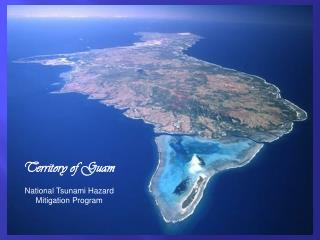
The US Territory of Guam. Jason Biggs. University of Guam Marine Laboratory. Background. unincorporated US territorial possession (DOI) High Island, strategic location in western North Pacific Ocean Size: 541 km 2 EEZ: ~218,000 km 2 Population: 175,877 (Jan. 2008 est.)

E N D
The US TerritoryofGuam Jason Biggs University of Guam Marine Laboratory
Background • unincorporated US territorial possession (DOI) • High Island, strategic location in western North Pacific Ocean • Size: 541 km2 • EEZ: ~218,000 km2 • Population: 175,877 (Jan. 2008 est.) • GDP $2.5 billion; GDPper capita $28,860 (2007) • 2006 unemployment rate 6.9% • 12% increase in immigrant alien workers last 6 mo. (28% TLF) • Ethnicity: Chamorro 37.1%, Filipino 26.3%, other Pacific islander 11.3%, white 6.9%, other Asian 6.3%, other ethnic origin or race 2.3%, mixed 9.8% (2000 census) • Economy: Tourism and Military spending
Major Environmental Issues • U.S. Military buildup • Renewable energy • Fishing vs. Marine Preserves • Pollution – waste management
Military build-up • infrastructure strain • habitat destruction • development in anticipation
Pollution • ½ of beaches were unsafe in 2001 • solid waste • Tanguisson • Cocos Lagoon
Marine Preserves Are they working?
Yes & No • The Preserves are a HUGE success. • People are still getting caught. • 1.5 DAWR agents patrolling part time. • Guam is one of last Pacific strongholds for SCUBA-fisherman.
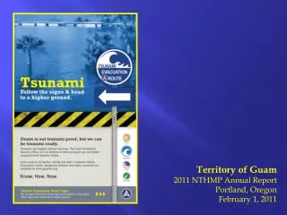
Storm Surge, Tsunamis, Sea Level Rise, and Erosion • Given the immediate need for policy and action pertaining to the military build-up, pollution, rising energy costs, and struggles surrounding fishing rights, although deemed interesting, Guam does not foresee an immediate need for modeling the loss of land.
But... When the sea level does rise, we should already have the tools necessary to exist in this changed environment. • i.e., salt tolerant taro
Data Collection – WHO? • US Navy- Bathymetric, macro-current • UOGML- Biological, ~current, uptake • DAWR- Fish creel, endangered/invasive spp. • UOG CNAS- Watershed, aqua-, agri-, outreach • NPS- current • Guam EPA- Water quality, etc. • WERI- Hydrology, water chem., etc. • UOG/NWS- Communication/Modeling • NOAA- Guam Coral Reef Atlas, Satellite Imagery
Who wants to know? • UOG • GBB • DAWR • EPA • NWS • Banks • GU Bureau of Planning CZM • GU Visitor’s Bureau • Guam Shell club • Guam Fishermen’s Co-op. • Guahan Napu Inc. • TASI
What do they want? • Capacity • Circulation Models w/ incorporate • Larval Dispersal • Pollution Outfall • Underwater surveys beyond SCUBA depths • Efforts to explore alternative energy • wave-energy • Resource Management/Bioremediation Training