Download

1 / 21
210 likes | 219 Vues
Hurricane Katrina: Before and After the Storm. “There are only two kinds of levees, those that have failed and those that will fail.”. Before Katrina. Previous hurricane damage from less severe storms 1965- Hurricane Betsy put parts of the city under 8 feet of water

E N D
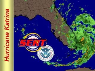
Hurricane Katrina: Before and After the Storm “There are only two kinds of levees, those that have failed and those that will fail.”
Before Katrina • Previous hurricane damage from less severe storms • 1965- Hurricane Betsy put parts of the city under 8 feet of water • 1992- Hurricane Andrew missed by 100 miles • 1998- Hurricane George causes billions of dollars of damage, but it was not a direct hit • Disappearance of barrier islands and marshes due to construction
Facts and Figures: • “A hurricane storm surge can reach heights of 20 feet, but every 4 miles of marsh can absorb enough water to knock it down by one foot.” • Oil & gas exploration has accounted for 1/3 of the delta’s landloss • Coast provides 1/3 of country’s seafood, 1/5 of its oil, and 1/4 of its natural gas & harbors 40% of the nation’s coastal wetlands and provides wintering grounds for 70% of migrational water fowl • An acre of coastal wetlands disappears every 24 minutes
Fixes: • Attempts to restore marsh ecosystem • Coast 2050 • River system on critical areas of Mississippi • Levees to allow fresh water to escape and wash out sediments to Gulf • 5000 cubic yards of sand transported to restore barrier islands • Millenium Port
Protecting New Orleans • 1998- $14 billion plan proposed to restore wetlands rejected by Congress
Record sea surge of Katrina peaked at 28 feet • State of the art barriers can only contain a surge reaching 15 feet • Plans for the future will improve the levees of the city to Category 5 levels • Ideal plans would take 5-10 years to build and cost $25-35 billion dollars
Possible Plans • Not using the Army Corp of Engineers for contractors • Outer Shield • Floating gates • Sluices that slide • Hydraulic disks • Rising flaps
Grand Plan • Three protection schemes: • Inner ring • Comprehesive plan • Outer shield
Delta formation • Forms a dynamic landscape of wetlands that have been eroded by human activity • Barrier islands evolve but human activities speed up shrinkage • Island restoration has to be a priority to protect the delta in the future.
After Katrina • Scientists and engineers aren’t the only ones involved in the process- stakeholder engagement • Demonstration project for other coastal regions • Investment for restoration is still being debated
Levee Construction • Army Corp of Engineers rebuilds after Hurricane Betsy • High Level option- raise all barriers to resist a Category 3 hurricane (16-18.5 feet above sea level) • Barrier option- construct levees and gates between Lake Brogne and Lake Pontchartrain, and navigation lock, rock dike and flood control structure on Industrial Canal at Lake Pontchartrain
Impact of NEPA court case • 1976 lawsuit filed by Save Our Wetlands alleged that Army Corp of Engineers FEIS (Final Environmental Impact Statement) for levee construction is inadequate and WINS. • Corp reevaluates building plan, changing from barrier to high level plan
Would the original plan have saved the city? • Probably not. Levees failed for several reasons: • Insufficient depth of pilings • Unstable underlying soils • Lax maintenance practices
Would the original plan have saved the city? • Storm surge came from Lake Borgne, not Lake Pontchartrain • Barrier project may have exacerbated the damage by deflecting surge
Would the original plan have saved the city? • MRGO • Shrinks from 2000 to 200 feet wide • Intensified storm surge by 20% • Increased velocity of surge from 3 to 6-8 feet per second
Storm Surge modeling • http://www.nd.edu/~adcirc/katrina.htm • The first detailed computer model of Hurricane Katrina's storm surge shows a gargantuan, 15-foot dome of water forming in the Gulf of Mexico. Propelled westward by 140-mph winds, the surge slams into levees east of New Orleans and pours over them, flooding a large inhabited area. • Later, the model shows water flooding most of the rest of New Orleans from Lake Pontchartrain through levee breaches. Meanwhile, Katrina's giant wave continues its relentless northeast course, pushing a 30-foot wave over the Biloxi-Gulfport area in Mississippi.


![[The Hurricane]](https://cdn1.slideserve.com/1952424/the-hurricane-dt.jpg)