Download
1 / 15
170 likes | 421 Vues
Marine Protected Areas (MPA) Project. Overview of project and Geoprocessing. What is an MPA? . An area set aside for conservation. www.mpa.org. MPA Definition . Federal Definition

E N D
Marine Protected Areas (MPA) Project Overview of project and Geoprocessing
What is an MPA? An area set aside for conservation www.mpa.org
MPA Definition • Federal Definition • MPA is a general term for places given special protections for natural or historic marine resources by local, state, federal or tribal authorities national parks • wildlife refuges • Monuments • marine sanctuaries • fisheries closures • critical habitat • habitat areas of particular concern • state parks, • conservation areas estuarine reserves and preserves http://www.mpa.gov/what_is_an_mpa/definition.html
MPA Definition • Constancy of Protection • Year-Round • Seasonal • Rolling • Scale of Protection • Ecosystem • Focal Resource • Allowed Extractive Activities • Commercial Fishing • Recreational Fishing • Subsistence Hunting/Fishing • Scientific/Educational Collecting • Mineral/Energy Extraction • Other • Primary Conservation Goal • Natural Heritage • Cultural Heritage • Sustainable Production • Level of Protection • No Access • No Impact • No Take • Zoned With No-Take Areas • Zoned Multiple Use • Uniform Multiple Use • Permanence of Protection • Permanent • Conditional • Temporary http://www.mpa.gov/what_is_an_mpa/definition.html
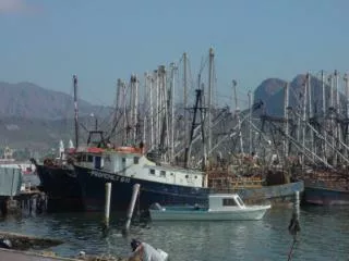
Fisheries management tools • Management tools for fisheries • Quotas – how many • Size limits – how big • Gear restrictions – trawling prohibited within shoreline to 3 mi • Time based restrictions • Spatially (place) based – • Rockfish conservation areas • Cowcod conservation areas • Marine protected areas
California's MPAs - Marine Life Management Act • 1999 - California State Legislature direct the state to design a network marine protected areas • MPA – six classifications • State Marine Reserves • No take • State Marine Park • Some recreational fishing allowed • State Marine Conservation Areas • Some recreational and commercial fishing allowed http://www.dfg.ca.gov/mrd/mlma/index.html
California's MPAs - Marine Life Management Act • Central Coast Project (Point Conception to Pigeon Point) • Proposed network of MPAs from Point Conception to Pigeon Point by 2006 • Rest of the coast between 2006-2011 • Public input critical! • Stakeholders (recreational angling and diving, commercial fishing, ports and harbors, conservation, business ) http://www.dfg.ca.gov/mrd/mlma/index.html
California’s Fisheries • Pacific Fisheries Information Network (PacFin) • Fishery catch reported by the commercial industry • Landings (lbs) • Species • Year • Location (10 nm blocks) http://www.psmfc.org/pacfin/overview.html
Your mission is to select MPAs that consists 1 and 2 contiguous fishing blocks that: • Have a depth equal to or less than 1200 m • The bottom substrate is either hard or mixed • Is more than 25 nautical miles from Moss Landing and Morro Bay • Will not heavily impact fishers
New Tools you will use: • Geoprocessing – in ArcTool Box • Dissolve • Merge • Intersect • Clip • Buffers • Summarizing Tables • Joining Tables • Model Builder
Combines input features from multiple input sources (of the same data type) into a single, new, output feature class. The input data sources may be point, line, or polygon feature classes or tables. Merge Data Management Tools> General > Merge
Intersect This tool builds a new feature class from the intersecting features common in both feature classes. It retains the attributes of both feature classes. Analysis Tools> Overlay > Intersect
Clip • This tool uses a polygon boundary to cut features and their attributes from a feature class. Works like a cookie cutter. Analysis Tools> Extract > Clip
Buffer • This tool creates a new feature class of buffer polygons around either polygon, line, or point features. Analysis Tools> Proximity > Buffer
Dissolve • This tool combines like features based on a specified attribute or attributes. Data Management Tools> Generalization > Dissolve