Download
1 / 12
120 likes | 121 Vues
This article discusses the promotion and compatibility of GRID technologies in creating web mapping services. It explores the use of openGIS and web services for interoperability and the utilization of large EO databases.

E N D
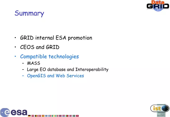
Summary • GRID internal ESA promotion • CEOS and GRID • Compatible technologies • MASS • Large EO database and Interoperability • OpenGIS and Web Services
Creating GRID Services for Web Mapping Pedro Pereira Gonçalves
OpenGIS Consortium • International Consortium of 220 companies, governmental agencies and universities • Consensus building for geographic information public access interfaces • Interoperable solutions for geographic services in internet and mobile communications Web Map Service Specification
URL Webmap Service Environmental Data USER Location Based Services Catalogue Systems Satellite Images Geographical Data Web Map Services
Web Map Services http://inovagis.dcea.fct.unl.pt/giserver/map.exe? VERSION=1.1.0&REQUEST=GetMap& LAYERS=rgb(portugal.noaa.band1,portugal.noaa.band2,portugal.noaa.band3)& WIDTH=229&HEIGHT=450& BBOX=70000,-10000,375000,590000& SRS=SHGM& FORMAT=JPEG& TIME=2000-08-09& STYLES=max300, max300, max300 Fire Detection
Auxiliary Information VERSION=1.1.0&REQUEST=GetMap&LAYERS=rgb(PORTUGAL.NOAA.BAND1,PORTUGAL.NOAA.BAND2,PORTUGAL.NOAA.BAND3),PORTUGAL.CONC&WIDTH=440&HEIGHT=440&BBOX=138800,232800,187200,281200&SRS=SHGM&FORMAT=JPEG&TIME=2000-08-09&STYLES=max300,text18+portugal.conc.text_concelhos&EXCEPTIONS=application/vnd.ogc.se_inimage VERSION=1.1.0&REQUEST=GetMap&LAYERS=PORTUGAL.CONC &WIDTH=440&HEIGHT=440&BBOX=138800,232800,187200,281200&SRS=SHGM&FORMAT=GIF&STYLES=text18+portugal.conc.text_concelhosEXCEPTIONS=application/vnd.ogc.se_inimage
Image Processing Services Filter
GRID on demand WebMapService User Geographic Information Services System Cache Temporal Data Access Time Series
Potential for “GRID on demand” Services • Catalogue Searching • Automatic Image Mosaic • Classification • Environmental Data Processing
External GRID Server Server User Certificate Authority GeographicInformation GRID Service Layer Broker Web Access to GRID Services
HTTP Server DataGrid HTTP Server CGI, ISAPI, ASP, PHP, etc. Globus Grid OGC Web Map Server Specification Geo Cache System JDL Files Data Certificate Authority Implemented by inovaGIS External Clients Internet Boundary External HTTP servers 3rd-Party Elements Only in Win-OS COM DiskFile inovaGIS COM objects(freeware) Web ClientHTTP-based request Web ServerIIS, Apache HTTP HTTP HTTP GIServer CGIISAPI GIServer WMSEXE, DLL HTTP SOAP Client C#, Delphi, PHP, JAVA GIServer WebServiceDelphi SOAP COM SOAP HTTP COM ClientDelphi, Excel, VB, ASP, C++ GIServer TCP/IPNT Service DiskFile TCP/IP GRID Service Layer Broker Presentation Tier | Business Logic Tier | Data Tier Note: The arrows go from the caller to the recipient.