Download
1 / 1

E N D
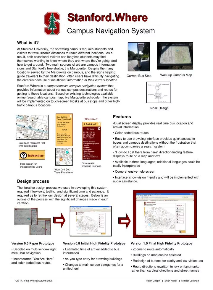
Stanford.Where Campus Navigation System What is it? At Stanford University, the sprawling campus requires students and visitors to travel sizable distances to reach different locations. As a result, both occasional visitors and longtime students may find themselves wanting to know where they are, where they’re going, and how to get around. Two main sources of aid are campus information signs and Stanford’s free shuttle, the Marguerite. Despite the many locations served by the Marguerite on campus, and the signs helping guide travelers to their destination, often users have difficulty navigating the campus because of insufficient information at their current location. Stanford.Where is a comprehensive campus navigation system that provides information about various campus destinations and routes for getting to these locations. Based on existing technologies available online (searchable campus map, live Marguerite schedule) the system will be implemented on touch-screen kiosks at bus stops and other high-traffic campus locations. Walk-up Campus Map Current Bus Stop Kiosk Design • Features • Dual screen display provides real time bus location and arrival information • Color-coded bus routes • Easy to use browsing interface provides quick access to buses and campus destinations without the frustration that often accompanies a search system • “How do I get there from here” direction-finding feature displays route on a map and text • Available in three languages; additional languages could be easily incorporated • Comprehensive help screen • Interface is low-vision friendly and will be implemented with audio assistance. Bus icons represent real-time bus location Easy-to-use browsing interface Help screen for inexperienced users “How Do I Get There From Here” Design process The iterative design process we used in developing this system required interviews, testing, and significant time and patience. It required us to rethink our design at several stages. Below is an outline of the process with the significant changes made in each iteration. • Version 0.5 Paper Prototype • Decided on multi-window right menu bar navigation • Incorporated “You Are Here” and color-coded bus routes. • Version 0.8 Initial High Fidelity Prototype • Estimated time of arrival added to bus information • As-you-type entry for browsing buildings • Changes to main screen categories for a unified feel • Version 1.0 Final High Fidelity Prototype • Zooms to route automatically • Buildings on map can be selected • Redesign of buttons for clarity and low-vision use • Route directions rewritten to rely on landmarks rather than cardinal directions and street names CS 147 Final Project Autumn 2005 Karin Chapin ■ Evan Kutter ■ Kimber Lockhart