Download
1 / 1
10 likes | 109 Vues
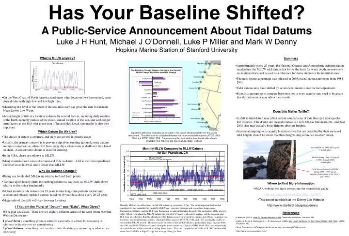
The Elevation Change Between Datums is Site-Specific MLLW Change May Differ from MSL Change. MLLW of these data. 3.1. Friday Harbor. -3.9. Neah Bay. -3.2. Astoria. 4.6. Depoe Bay. 1.2. Coos Bay. 0.9. Crescent City. 6.4. San Francisco. 7.4. Monterey. 3.6. Santa Barbara.

E N D
The Elevation Change Between Datums is Site-Specific MLLW Change May Differ from MSL Change MLLW of these data 3.1 Friday Harbor -3.9 Neah Bay -3.2 Astoria 4.6 Depoe Bay 1.2 Coos Bay 0.9 Crescent City 6.4 San Francisco 7.4 Monterey 3.6 Santa Barbara MLLW Change (with value) 4.3 MSL Change Los Angeles 6.3 San Diego -6 -4 -2 0 2 4 6 8 Difference between Datums (cm) Monthly MLLW San Francisco MLLW Datum Has Your Baseline Shifted?A Public-Service Announcement About Tidal DatumsLuke J H Hunt, Michael J O’Donnell, Luke P Miller and Mark W DennyHopkins Marine Station of Stanford University What is MLLW anyway? Summary • Approximately every 20 years, the National Oceanic and Atmospheric Administration recalculates the MLLW tidal datum that forms the basis for water depth measurement on nautical charts and is used as a reference for many studies in the intertidal zone. • The most recent adjustment was released in 2003, based on measurements from 1984-2001. • Tidal datums may have shifted by several centimeters since the last adjustment. • Scientists attempting to compare between sites or to re-acquire sites need to be aware that this adjustment may affect their results. • On the West-Coast of North America (and many other locations) we have mixed, semi-diurnal tides with high-low and low-high tides. • Measuring the level of the lower of the low tides eachday gives the data to calculate Mean Lower Low Water. • Actual height of tide at a location is driven by several factors, including daily rotation of the Earth, monthly periods of the moon, annual location of the sun, and such longer term factors as the 18.6 year precession of lunar nodes. Local topography is also very important. Does this Matter To Me? • A shift in tidal datum may affect certain comparisons of data that span tidal epochs. For instance, if field sites are located relative to a zero MLLW tide mark, pre- and post 2003 sites may actually be at different absolute heights. • Anyone attempting to re-acquire historical sites that are described by their surveyed tidal heights should be aware that these heights may reference an older datum. Which Datum Do We Use? A positive difference indicates an increase in the datum elevation relative to the station benchmark. The difference is calculated between the most recent tidal datums (NTDE 1983-2001 and NTDE 1960-1978). Data are compiled from station benchmark data sheets available from http://co-ops.nos.noaa.gov/data_res.html. • The choice of datum is arbitrary, and there are several in general usage. • Usually, the primary concern is to prevent ships from running aground; some datums are more conservative, others will have many days when water is shallower than listed on chart. A conservative datum is used for charting. • In the USA, charts are relative to MLLW. • Many countries use Lowest Astronomical Tide as datum. LAT is the lowest predicted tide level in an interval, and is lower than MLLW. New MLLW for 1983-2001 epoch 7.4 cm higher MLLW during 1960-1978 epoch (1980’s through 2003) .6 cm higher Field Site established at MLLW during 1941 – 1959 epoch (anytime during most of the 1960’s and 1970’s) Why Do Datums Change? • Rising sea levels shift MLLW up relative to fixed Earth points. • Tectonic uplift locally shifts the earth up relative to sea level, so MLLW shifts down relative to the rising benchmarks. • NOAA monitors tide stations for 19 years to take long-term periodic factors into account and releases updated datums based on 19 year data about every 20-25 years. • Magnitude of the shift will vary between locations. Where to Find More Information • NOAA website will have corrections for nearest tide gauge • http://co-ops.nos.noaa.gov/data_res.html • This poster available at the Denny Lab Website • http://www.stanford.edu/group/denny References Monthly MLLW can differ from the MLLW datum by as much as 0.5m. The most important factors that contribute to this variability in monthly MLLW are: seasonal pressure and sea surface temperature fluctuations, El Nino, and the 18.6-year fluctuation in tidal amplitudes driven by the inclination of the moon’s orbit. When computing the MLLW datum, the period of 19 years is chosen to average out the seasonal and 18.6-year periodicities, thus the elevation of the datum is most influenced by changes in El Nino frequency, sea level rise, and local tectonic activity. Strong El Nino years of 1957-58, 1983, and 1997 are clearly visible in the monthly MLLW record. The most recent increase in the MLLW datum is particularly large, because both the 1983 and 1997 El Ninos occurred during the most current tidal epoch (NTDE 1983-2001) and temporarily increased the sea surface elevation during those years. Data are compiled from Hicks et al 1983 and monthly mean data available at http://co-ops.nos.noaa.gov/data_res.html. I Thought the Plural of ”Datum” was ”Data”, What Gives? We’re glad you asked. There are two slightly different senses of the word (from Merriam-Webster Dictionary) 1pluralda·ta: something given or admitted especially as a basis for reasoning or inference is the one you are remembering2pluraldatums: something used as a basis for calculating or measuring is what we are discussing References • Calder, N. (2003). How To Read a Nautical Chart. International Marine, Camden, ME. • Hicks, S. D., H. A. Debaugh Jr., L. E. Hickman Jr. (1983) Sea Level Variations for the United States 1855-1980. NOAA Rockville, MD. • Scott Duncan from NOAA provided immense help accessing NOAA records. • http://www.merriamwebster.com/