Download
1 / 18
180 likes | 325 Vues
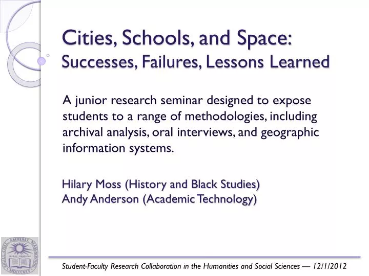
Cities, Schools, and Space: Successes, Failures, Lessons Learned. A junior research seminar designed to expose students to a range of methodologies, including archival analysis, oral interviews, and geographic information systems. Hilary Moss (History and Black Studies)

E N D
Cities, Schools, and Space:Successes, Failures, Lessons Learned A junior research seminar designed to expose students to a range of methodologies, including archival analysis, oral interviews, and geographic information systems. • Hilary Moss (History and Black Studies) • Andy Anderson (Academic Technology) Student-Faculty Research Collaboration in the Humanities and Social Sciences — 12/1/2012
In America, a child’s address, more than any other factor, often determines what kind of public education he or she will receive. A complex set of historical forces including local and federal housing policies, mortgage lending practices, highway construction, and school districting have channeled particular economic, racial, ethnic, and linguistic groups into particular neighborhoods, where many remain today. Students and parent atTobin School, Cambridge Web Page
This course involves a significant research component designed to expose students to a range of approaches including archival analysis and oral interviews. In particular, students will learn to utilize geographic information systems (GIS) to visualize the spatial evolution of inequality in urban communities like Cambridge and to analyze past, present, and future strategies to equalize educational opportunity in American cities. Students and parent atTobin School, Cambridge Web Page
Extensive readings: broader histories and original research studies, including GIS applications • Zotero & Endnote bibliography databases (thanks to librarian Gretchen Gano) • Guest speakers via Skype to discuss both content and research process • Local archive of material collected from MIT, Harvard, and the Cambridge Historical Society • Also newspaper microfilm • Field trip to Cambridge Web Page
Progressive GIS assignments that related directly to the syllabus • Culmination in basic spatial statistics & models • Optional lab hours where help was always available Web Page
Collaborative assignments that tied planning documents and census data together Web Page
Submit a short, narrative research proposal and bibliography describing the research project you hope to pursue during the second half of the semester.As you are framing your proposal, recall two questions which have been at the forefront of our class discussions: How did race, property, and educational opportunity become entangled in Cambridge during the twentieth century? Why and how did Cambridge — as a community — attempt to disentangle race and property from educational opportunity in the late twentieth century? Remember that while GIS analysis does not have to be your primary research method, your final project should make use of GIS in some way.We would also like you to complete at least one oral history for your project as well. Cambridgeport School, Cambridge Web Page
Why were the West Cambridge enrolment projections reported in the 1970 Elementary Schools Building Study so off-base? • Did race and/or class influence decisions about where to build new schools, renovate existing ones, or to close schools in the decade(s) before the implementation of controlled choice in Cambridge? • Considering the original demographics of Cambridge High and Latin School and Rindge School of Technical Arts, how did the merging of these two educational institutions effect the overall enrolment of the high school and the social, racial, and spatial make-up of the new integrated student body? • What motivated the reorganization of Cambridge High and Latin School and Rindge School of Technical Arts, and what issues were those who were involved in planning the reorganization considering? • What were the social, spatial and political tensions that caused the racial integration and linguistic integration movements to become counterproductive to one another, culminating with the failure of Bilingual Education within the Cambridge Public schools? • Why was the Kendall Square Urban Renewal Project controversial? • How did M.I.T. use its political leverage to influence the geographic choices of Inner Belt and how were M.I.T. students, faculty, and local community involved in the anti-Inner Belt campaign? • What role did MIT have in shaping development of Cambridge as a city in terms of race and space? Cambridge Public Library Web Page
Conferences and Papers • Why were the West Cambridge enrolment projections reported in the 1970 Elementary Schools Building Study so off-base? • Did race and/or class influence decisions about where to build new schools, renovate existing ones, or to close schools in the decade(s) before the implementation of controlled choice in Cambridge? (SSHA) • Considering the original demographics of Cambridge High and Latin School and Rindge School of Technical Arts, how did the merging of these two educational institutions effect the overall enrolment of the high school and the social, racial, and spatial make-up of the new integrated student body? • What motivated the reorganization of Cambridge High and Latin School and Rindge School of Technical Arts, and what issues were those who were involved in planning the reorganization considering? • What were the social, spatial and political tensions that caused the racial integration and linguistic integration movements to become counterproductive to one another, culminating with the failure of Bilingual Education within the Cambridge Public schools? (AERA) • Why was the Kendall Square Urban Renewal Project controversial? • How did M.I.T. use its political leverage to influence the geographic choices of Inner Belt and how were M.I.T. students, faculty, and local community involved in the anti-Inner Belt campaign? (HES) • What role did MIT have in shaping Cambridge as a city in terms of race and space? Cambridge Public Library Web Page
Theses • Why were the West Cambridge enrolment projections reported in the 1970 Elementary Schools Building Study so off-base? • How do the Rich Die? Understanding the Association Between Income and Health Care Utilization at the End of Life (Economics) • Gender, Regional, and Racial Differences in Autobiographical Memory Narratives (Psychology) • Within These Walls (Art and the History of Art) • What were the social, spatial and political tensions that caused the racial integration and linguistic integration movements to become counterproductive to one another, culminating with the failure of Bilingual Education within the Cambridge Public schools? • Cultivating Space: A History of Urban Renewal in Kendall Square (History) • Investigating the Relationship Between Social Norms, Family Background, and Student Achievement (Economics) • The Embarcadero Freeway: The Birth, Life, and Death of an American Highway (History) Cambridge Public Library Web Page
Lessons Learned • With no formal requirements for participation, there were a range of backgrounds in history, research skills, computer skills, and statistics. • Some students love using GIS and actively apply it, sometimes even in other classes; others put up with it. • Students appreciated thecourse’s distinctive character and collaborative nature, and learning to do research. • Students enjoyed seeing us learning GIS and history along with them. • Rewarding and productive for us!
Responding to the Inner Belt Hwy.— Yinan Zhang • Proximity Analysis • Tract-based • Two characteristics stands out!
Responding to the Inner Belt Hwy.— Yinan Zhang • Final Alternatives: • MIT doesn’t want the highway adjacent to their campus. • The Brookline-Elm neighborhoods don’t want it, either! • End result: neither is built!
What Influenced School Building?— Josie Fisher • During the 1960s and 1970s: • Six new or reconstructed schools • But many schools in worse condition!
What Influenced School Building?— Josie Fisher • Parcel Analysis • Distribute censusinfo by housing type on parcels


![The LIFE LESSONS LEARNED FROM A DANDELION (7) [motive]](https://cdn1.slideserve.com/2228602/the-life-lessons-learned-from-a-dandelion-7-motive-dt.jpg)