Download
1 / 59
620 likes | 1.06k Vues
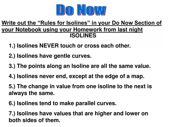
Do Now. Write out the “Rules for Isolines” in your Do Now Section of your Notebook using your Homework from last night. ISOLINES 1.) Isolines NEVER touch or cross each other. 2.) Isolines have gentle curves. 3.) The points along an Isoline are all the same value.

E N D
Do Now Write out the “Rules for Isolines” in your Do Now Section of your Notebook using your Homework from last night ISOLINES 1.) Isolines NEVER touch or cross each other. 2.) Isolines have gentle curves. 3.) The points along an Isoline are all the same value. 4.) Isolines never end, except at the edge of a map. 5.) The change in value from one isoline to the next is always the same. 6.) Isolines tend to make parallel curves. 7.) Isolines have values that are higher and lower on both sides of them.
Constructing and Interpreting a Field Map http://www.stadiumsofnfl.com/afc/GiantsStadium.htm
Models and Dimensions of Earth - 14 V. Fields - Any region of space or the environment that has some measurable value of a given quality at every point A. Isolines- Lines that connect points of equal field values
What is the approximate elevation of point A. 75 feet B. 45 feet C. 55 feet 2. Isolines that show elevation are called Contour Lines
1. What measurable property is shown on this map? TEMPERATURE °C 2. Based on this property, the isolines on this map are called ISOTHERMS 3. What is the approximate measurement of this property for New York State? 5 ° C
1. Approximately how many thunderstorms occur each year in: a. Albany, New York - ~ 25 thunderstorms b. Los Angeles, California- ~ 5 thunderstorms c. New Orleans, Loisiana - ~ 75 thunderstorms
ISOLINES • Do isolines ever touch or cross each other? • 2. Do isolines usually have sharp angles or gentle curves? • (Please pick one.) • 3. What does each point on an isoline have in common with all other on the same line? • 4. Do isolines ever end, except on the edge of the map? NO Gentle Curves They all have the same value NO
ISOLINES 5. Is the change in value from one isoline to the next always the same on a single map? 6. Do isolines tend to make parallel curves? 7. Does every isoline have one side where the values are higher and another side where the values are lower? YES YES YES
Relief Map Difference in elevation between the high and low points of a land surface
Directions: Use a Pencil to draw the snowfall line on map 1 every 20 inches. Be sure to extend your isolines to the edge of the map if necessary.
Directions: Use a Pencil to draw contour lines every 10 feet. Be sure to extend your isolines to the edge of the map if necessary.
10.29 AIM: How do we Read Topographic Maps? Do Now: Take out Note Packet H.W. Isoline Practice
VI. Topographic Maps … are maps of an elevation field A. Topographic Maps show the elevation of the land by using contour lines, and show other natural and man-made features using symbols. B. Contour Line- Isolines that connect elevation above and below sea level. Elevation - The vertical distance or height above sea level. The difference in elevation between two consecutive contour lines. C. Contour Interval- D. Index Contour Line- Darker contour lines marked with elevations
Topographic Map- Showing Contour Lines What is the Contour Interval?
E. Depression Contour Line- Special contour line used to show a hole or crater on Earth’s surface. These lines are drawn like contour lines but are marked on the inside. * The first depression contour line has the same value as the last regular contour line. Each smaller and smaller depression contour line is one contour interval less than the previous line.
F. Bench Mark (B.M,)- A metal marker in the ground labeled with an exact elevation for a location.
Spot Elevations- are the elevations of such places as road intersections, hilltops, lake surfaces and other points of special interest. These points are located on the map by a small cross (+), unless the location is obvious, such as certain road intersections or hilltops.
80 feet 140 feet 100 feet
20 feet 4. Contour Interval- 5. Highest possible elevation (of the hilltop)- 259 feet 6. Which is the steepest side of the hill? East
10.31 AIM: How is gradient calculated? Do Now: Rates and Gradients II H.W. UPCO pages 35-37 questions 1-10 Test on Friday
7. How do contour lines show a steeper slope? Closely spaced contour lines show a steeper slope
8. What three (3) basic features of a landform do contour lines show? a. Hills- shown by closed concentric circles of contour lines.
b. Cliffs- shown on a topographic map, where contour lines are spaced very close together.
c. Depressions- marked with small lines pointing toward the center of a depression.
I. River Valleys (the law of V’s) – contour lines bend upstream where they cross a river. This can be used to determine the direction in which the river is flowing.
The direction of a river can be found on a topographic map two ways: 1. Contour lines bend upstream- All rivers flow downstream. 2. Look at the elevation the river flows through. Rivers flow downhill or from High elevation to a Low elevation.
Base your answer to this question on the topographic map below. Points X, Y, and Z are locations on the map. Elevations are expressed in meters.Mill River generally flows toward the North East There are a couple of different ways to tell which direction Mill River flows. They are: - smaller bodies of water flow into larger bodies of water - the contour arrows point in the opposite direction the stream in flowing - higher to lower elevation Using all or one of these one can tell the stream is flowing in a NE direction.
J. Common Symbols on Topographic Map Swamp or Marsh 1. 5. Building 2. 6. Railroad Church 3. 7. Cemetery 8. 4. School Mine
1. Dublin is of Manchester. West VII. Map Reading Skills 2. Manchester is of Dublin. East 3. Southampton is of Dublin. Southeast 4. Belfast is of London. Northwest 5. Glasgow is of Cardiff. North 6. Limerick is of Aberdeen. Southwest 7. Aberdeen is of Limerick. Northeast South 8. Manchester is of Newcastle.
100 miles ~180 miles 50 miles 225 miles 150 miles ~390 miles Dublin to Oxford
80 feet 120 feet 100 feet 60 feet 80 feet 100 feet 40 feet 60 feet 40 feet 20 feet 20 feet
A A’
. . . 120 . . . 100 . . 80 . . 60 . . 40 20 A’ A
Gradient – (SLOPE) a measure of how steep the land is. Gradient = Change in Field Value Distance 1. Formula: 2. Calculating Gradient Use the elevation field map that you drew contour lines on (which is on the previous page) to calculate the gradient between: a. Point A and point C Reference Table page = b. Point B and point D Page 1 Equations c. Point B and point E d. Point F and point C
a. Point A and point C G = ∆ in field value = 110 -20 feet = 90 ft. = 25 feet/mile distance 3.6 miles 3.6 mi. b. Point B and point D G = ∆ in field value = 123-13 feet = 110 ft. = 36.7 feet/mile distance 3 miles 3 mi. c. Point B and point E G = ∆ in field value = 123-80 feet = 43 ft. = 28.7 feet/mile distance 1.5 miles 1.5 mi. d. Point F and point C G = ∆ in field value = 27-20 feet = 7 ft. = 4.7 feet/mile distance 1.5 miles 1.5 mi.
atmosphere hydrosphere lithosphere (crust) 30 atmosphere hydrosphere lithosphere (crust) lithosphere (crust) atmosphere
Outer Core CRUST Mantle Inner Core
Base your answer to this question on the topographic map below. Points X, Y, and Z are locations on the map. Elevations are expressed in meters.What is the elevation of point Z? 220 meters Using the contour interval located at the bottom of the map (20 meters) one can find the elevation of point Z. Since the contour line that surrounds Z is 200m and Z is one line up from 200 the answer would match with 220m.
The numbers on the map represent the concentration of gasoline found at that location. What is the name of the line that we would connect equal values on this map? Isolines
What is the Isoline Interval of this field map? Isoline Interval = 10
What does the closely spaced contour lines indicate? Close lines = Steep Slope