Download
1 / 42
430 likes | 619 Vues
Plate Tectonics Overview Jonathan Hendricks SJSU Department of Geology jhendricks@sjsugeology.org. BAESI: Earth and Life Through Time. Plate Tectonics Overview. Lecture Overview: Have the positions of continents moved through time? What is the history of the idea of continental drift?

E N D
Plate Tectonics Overview Jonathan Hendricks SJSU Department of Geology jhendricks@sjsugeology.org BAESI: Earth and Life Through Time
Plate Tectonics Overview Lecture Overview: Have the positions of continents moved through time? What is the history of the idea of continental drift? How does plate tectonics work? How do plates interact at their boundaries?
Slide shows an image of one tectonic plate being subducted beneath another. Plate Tectonics Plate Tectonics: The scientific theory that the surface of the Earth (lithosphere) is divided into plates that move relative to one another and that interact at their boundaries. Image from USGS
Slide shows a satellite map of the world. Map of the World Image from NASA
Slide shows two images made by geographer Antonio Snider-Pellegrini, 1858. One shows the continents separated. The other shows North and South America connected with Europe and Africa. History of Plate Tectonics Maps by geographer Antonio Snider-Pellegrini, 1858
Slide shows a photo of a Glossopteris fossil, as well as locations on the world map where Glossopteris fossils have been found. Glossopteris – “Seed Fern” Image from USGS Image from NASA Stars show places where Glossopteris fossils have been found.
Slide shows a photo of a Glossopteris fossil, as well as locations on the world map where Glossopteris fossils have been found. A circle shows the position of the ancient land mass known as “Gondwana”. Glossopteris Flora and Land Bridges? “Gondwana” Image from USGS Image from NASA Was sea level lower during late Paleozoic?
Slide shows a photograph of Alfred Wegener. Alfred Wegener (1880-1930) German meteorologist who proposed idea of “continental drift”:idea that continents moved (and continue to move) horizontally over the surface of the Earth. In 1915 presented evidence for a single supercontinent, which he called Gondwana. Early evidence presented by Wegener and other workers (especially Alexander du Toit) in support of continental drift: Continental fit. Rock sequences. Glacial flow directions. Rift valleys. Distributions of fossils. Image from USGS
Slide shows two images. One shows a picture of scratch marks on rocks caused by glacial flow. The second shows ancient glacial flow directions on the modern world map. The third shows that the glacial flow directions in the southern continents only make sense if the continents were once connected. Glacial Flow Directions Image from USGS Image from NASA
Slide shows two images. One is a map of northeastern Africa showing the positions of major rift valleys. The second shows a satellite photo of a rift valley. Rift Valleys of Africa From NASA Image from USGS
Slide shows the distributions of Glossopteris, Lystrosaurus, and Mesosaurus fossils when the southern continents are reunited as Gondwana. Fossil Evidence
History of Plate Tectonics Despite the extensive evidence that the positions of the continents have changed through time, most geologists rejected the idea of continental drift. This was because there was no known mechanism that could produce such change.
Inner core: mostly solid iron Outer core: mostly liquid iron Mantle: rocky material Crust: Oceanic crust Continental crust Pressure increases with depth. Slide shows two figures that detail the different parts of the interior of the Earth Interior of the Earth Images from USGS
Motion of iron-rich outer core creates a magnetic field. Earth acts like giant bar magnet with N and S poles. Geographic and magnetic poles offset. Slide shows a cartoon image of Earth’s magnetic field. Earth’s Magnetism Image from USGS
Magnetism is Recorded in Rocks Some rocks contain iron minerals. These minerals align themselves to Earth’s magnetic field as the rock forms. Iron particles in sedimentary rock align as they fall out of suspension from water. Iron particles in magma (igneous rocks) align before the magma cools. “Frozen” orientations preserve record of the ancient orientations of Earth’s magnetic field.
The seafloor became much better explored during the 1940-1960’s. WWII, sonar. Complex topography. Mid-oceanic ridges with central furrow. Volcanoes often associated with ridges. Slide shows an artist’s painting of the Mid-Atlantic Ridge. Study of the Seafloor Image from USGS
Slide shows a photograph of Harry Hess. Hess’ Hypothesis of Seafloor Spreading: 1962 Continental and oceanic crust move together. New oceanic crust forms from rising magma at mid-continental ridges Oceanic crust moves away from ridge as it cools. Mechanism: thermal convection. Harry H. Hess & Seafloor Spreading Image from USGS
Thermal convection is thought to be the process driving the movement of plates. Earth is hotter (due to radioactive decay - fission) in some portions of the deep mantle than in others. This causes the formation of convection cells that drag along overlying lithospheric plates - acts like conveyor belts. Think about a container full of boiling water. Slide shows two images. One is a cross-section through the Earth showing how convection cells in the mantle may operate. The other shows a container of boiling water. Thermal Convection Images from USGS
How could one test Hess’ hypothesis of seafloor spreading? What pattern should one find on either side of mid-ocean ridge systems if Hess’ hypothesis is true? Slide shows an image of the Mid-Atlantic Ridge. Testing Hess’ Hypothesis Image from Google Earth
The polarity of Earth’s magnetic field has “flipped” many times throughout the geologic past. The reason(s) why are not at all clear. Durations of “normal” and “reversed” polarity highly variable in length. Magnetic Reversals
During the early 1960’s, it was discovered that changes in Earth’s magnetic polarity have been recorded into rocks on the seafloor (oceanic crust) as they cooled. Symmetrical banding on each side of mid-oceanic ridge systems. Younger rock near ridge, older away. Slide shows two images that illustrate magnetic reversals on either side of a mid-ocean ridge. These reversals form symmetrical patterns on each side of the mid-ocean ridge. Test of Hess’ Hypothesis Images from USGS
Slide has one image showing the ages of different oceanic crust rocks in the world’s ocean basins. Ages of the World’s Ocean Basins Image from USGS
Hess’ Hypothesis Was NOT FalsifiedEnough support has since been provided for plate tectonics that the idea is now accepted as a unifying theory for geology.Simple idea with great explanatory power.
Slide shows the major plates of the world. Major Plates of the World Image from USGS
Slide shows a figure that details where recent earthquakes have occurred. Most occurred near plate boundaries. Plates Interact at Their Boundaries Image from USGS; Earthquakes over last 30 days (http://neic.usgs.gov/neis/qed/)
Three major types of plate boundaries: Divergent - plates diverge from each other. Convergent - plates converge toward each other. Oceanic-Continental - oceanic crust (denser) subducts (goes under) beneath continental crust. Continental-Continental - neither body of continental crust subducts (equal density). Transform - plates slide past each other. Different Plate Boundaries
Slide shows a figure that provides an overview of the three major types of plate boundaries: divergent plate boundaries, convergent plate boundaries, and transform plate boundaries. Different Plate Boundaries Image from USGS
Slide shows two images. The first shows a picture that illustrates a divergent plate boundary. The second shows the mid-Atlantic ridge system. Divergent Plate Boundary Mid-Atlantic Ridge Image from USGS Image from Google Earth
Slide shows two images. On is an illustration of a oceanic-continental convergent boundary. The second is an image of the west coast of South America, which is an oceanic-continental convergent boundary. Andes, South America Oceanic-Continental Convergent Plate Boundary Image from USGS Image from Google Earth
Slide shows three images. One is an illustration of a continental-continental convergent boundary. The second is an image of the Himalayan mountains, which is an example of a continental-continental convergent boundary. The third is a cartoon that shows how India crashed into Asia. Himalaya Mountains, Asia Continental-Continental Convergent Plate Boundary Image from USGS Image from USGS Image from Google Earth
Slide shows two images, both of which illustrate the positions of transform plate boundaries near the northwest coast of the United States. Transform Plate Boundary Northwestern United States San Andreas Fault Image from USGS Image from Google Earth
Earth Today Plate tectonic maps and Continental drift animations by C. R. Scotese, PALEOMAP Project (www.scotese.com)
Earth in the Cretaceous Plate tectonic maps and Continental drift animations by C. R. Scotese, PALEOMAP Project (www.scotese.com)
GONDWANA: South America, Africa, Antarctica, India, and Australia Earth in the Jurassic Plate tectonic maps and Continental drift animations by C. R. Scotese, PALEOMAP Project (www.scotese.com)
SUPERCONTINENT OF PANGEA!! Earth in the Permian Plate tectonic maps and Continental drift animations by C. R. Scotese, PALEOMAP Project (www.scotese.com)
Earth in the Devonian Plate tectonic maps and Continental drift animations by C. R. Scotese, PALEOMAP Project (www.scotese.com)
Earth in the Ordovician Plate tectonic maps and Continental drift animations by C. R. Scotese, PALEOMAP Project (www.scotese.com)
Earth in the Cambrian Plate tectonic maps and Continental drift animations by C. R. Scotese, PALEOMAP Project (www.scotese.com)
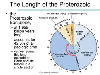
Earth in the Late Proterozoic Plate tectonic maps and Continental drift animations by C. R. Scotese, PALEOMAP Project (www.scotese.com)
Earth Today Plate tectonic maps and Continental drift animations by C. R. Scotese, PALEOMAP Project (www.scotese.com)
Earth in 150 Million Years Plate tectonic maps and Continental drift animations by C. R. Scotese, PALEOMAP Project (www.scotese.com)
Earth in 250 Million Years Plate tectonic maps and Continental drift animations by C. R. Scotese, PALEOMAP Project (www.scotese.com)