Download
1 / 27
270 likes | 298 Vues
BALWOIS 2006 , Conference on Water Observation and Information System for Decision Support Ohrid, 23-26 May, 2006. Some Features of the Nile River Basin Decision Support Tool. Mihailo Andjelic

E N D
BALWOIS 2006, Conference on Water Observation and Information System for Decision Support Ohrid, 23-26 May, 2006 Some Features of the Nile River Basin Decision Support Tool Mihailo Andjelic Republic Hydrometeorological Institute of Serbia (formerly Senior Technical Officer of the Food and Agriculture Organisation of U.N, Rome, Italy)
FAO Nile Basin Water Resources Projects Funded by Italy Second phase, ended December 2003 Third phase, still ongoing Ten participating countries: Burundi, DRC, Egypt, Eritrea, Ethiopia, Kenya, Rwanda, Sudan, Tanzania, and Uganda Focused on Capacity Building for Integrated Shared Vision Water Resources Management
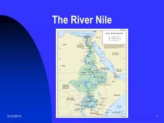
Climate ranging from tropical rainforest to arid zones Average annual flow: 84 bcm 85% originating from the Blue Nile, within the months of June to September Extensive losses through evaporation in the Sudd, Lake Nasser, and other lakes and wetlands Main water uses: irrigation, hydro- power, transport, industrial development, environmental protection, etc
Some More General Data: • Shared by 10 African countries • Ranges from 4 deg south 31 deg north • Runoff generated from 20 percent of the basin only • Major runoff contributing areas in • the Ethiopian Highlands- Blue Nile • Equatorial Lake Plateau - White Nile
Importance for NB countries • Rwanda, Uganda, Sudan and Egypt: almost completely dependent on Nile - no other significant sources of water • In Burundi, Rwanda and Ethiopia 100 percent of water generated inside countries’ borders ( zero dependence) • In Uganda 60, Sudan 23 and in Egypt only 3 percent of runoff generated inside countries’ borders
Water Consumption • Present : 82 km3/year • Year 2020 estimate: 144km3/year • Average runoff: 84km3/year • Corollary: • many Nilotic countries are already rather closed to water stress • future water demands are physically untenable without water use agreements and integrated water management - in fact, this is an inevitable necessity
Prerequisites for integrated water management • An institutional cooperative framework • Adequate monitoring system • A geo-referenced database and information system which includes relevant hydrometeorological, water demand and other data and information • Shared-vision planning and water resources modelling and management support tools • Technical expertise
Decision Support Systems/Tools Information Systems Methodologies/Models Data Acquisition/Computer Simulation, Forecasting, Interaction Technologies Optimization Data Bases Deterministic, Stochastic Geographic Information Systems Planning, Management Internet Assessment Other Information Sources Data, Information, Knowledge, Information Dissemination, Objectives, Constraints, Scenarios, Policy Options/Implications Methodologies, Assessments, Updates, Feedback Disciplines Actors … Climatology, Meteorology, Hydrology, … Politicians, Judges, Government Agencies, Ecology, Environmental Science, Agro - science, NGOs, Research Institutions, Academia, Engineering, Systems Analysis, Rem . Snsng ., Consultants, Citizen Groups, General Public, Socio - economics, Law, Politics, Public Policy, … Financial Institutions, Other Stakeholders, … Planning and Management Decisions
Guiding Principles in Developing Nile-DST • Based on latest science & technology able to handle the Nile basin size, complexity and multitude of water development options • “Neutral” technical decision support tool, whose overreaching purpose is to asses in unbiased manner the benefits and trade-offs of different water allocation/development strategies • Developed with involvement of users and stakeholders in the basin, thus promoting an environment of shared vision WD based on trustworthy knowledge base, data and information
Nile – DST is able to generate • Estimates of natural water resources regime (rainfall, runoff and river flow) in the Nile basin; this DST component is also capable of simulating the impacts of various climatic changes on water resources regime in the basin; • Benefits and trade-offs of agricultural/irrigation development plans on other water uses and users in the Nile Basin; • Benefits and trade-offs of hydropower development projects on other water uses and users with assessment of firm and non-firm energy generation potential; • Benefits and trade-offs of cooperative and non-cooperative water management strategies (“cooperative” being understood as acceptance, by the Nile partners, of an integrated shared vision water resources management in the Nile basin aimed at maximising the benefits - as opposed to status quo, non-cooperation, and fragmented water resources management);
Nile – DST is capable to generate… • Benefits and trade-offs of potential, large scale, wetland conservation projects; • Assessment of the existing information gaps in the Nile Basin and identification of an "optimal' water resources monitoring network able to satisfy the increased future data needs. • The system is capable of an easy and user friendly retrieval, storage, analysis and exchange of data, and information, including the DST outputs, between the Nile-DST and the geo-referenced database system established for the Nile Basin by the project; • The whole Nile-DST package is PC Windows NT based, developed with a user-friendly graphics interface and fully integrated with the geo-referenced database
Main Characteristics of the Developed Nile-DST • Nile-DST has six main components: • Database • River simulation and management • Agricultural planning • Hydrologic modeling • Remote sensing, and • User-model interface.
Database • A comprehensive data warehousing structure capable of storing and visualizing meteorological, hydrological, climatological, agricultural, river basin management, demographic and spatial data • Itis an object-oriented, data structure developed to • House all types of data (existing as well as future) required by water resources decision support tool; • To optimize data entry, access, visualization, and analysis • All together, this database contains some 37 gigabytes of information, the largest such collection ever compiled for the NileBasin.
River simulation & management • Simulates the Nileresponse under different hydrologic, development, and management scenarios • Its overriding purpose is to objectively assess the benefits and tradeoffs associated with various water development, sharing, and management strategies that may interest the NileBasin partners individually or as an interdependent community of nations. • Tradeoffs exist among water uses in the same country and across the Nile countries
Selected applications of river simulation & management RS & M can provide answers to various important questions. Typical applications are: • Value of various regulation, hydro-power, and irrigation projects along the White, Blue, and Main Nile branches; Such assessments could quantify the incremental benefits from individual development projects as well as the combined benefits from various project configurations; • Implications of reservoir regulation rules for local, upstream, and downstream riparians; • Marginal value (gain or loss) of irrigation with respect to hydropower at various basin locations; • Irrigation versus hydropower tradeoffs for each nation, region, and the entire basin.
Agricultural planning AP component is developed to assess the crop yield potential and irrigation needs at different locations within the Nile basin. It can be used for the following applications: • Crop growth and production can be simulated for 11 crops at any point in the NileBasin, based on historical climatology; • The optimal quantitative relationship between crop yield and irrigation (the “cropwater production function”) can be determined as a continuous function from rain-fed to fully irrigated conditions; • Optimized irrigation schedules can be found for all points on the crop-water production function;
Agricultural planning … • By simulating for multiple years of climatic data, variability of crop yield and irrigation needs can be determined; • Irrigation management for individual farms or irrigation districts can include information on yield-irrigation relationships, irrigation schedules, and sensitivity to other parameters provided by the module; and • Long-term planning decisions can include agricultural assessment results for questions of water availability and sharing.
Hydrologic modeling • Hydrologic watershed ( rainfall-runoff) models provide the means to describe the response of river basins (stream flow and soil moisture) to different conditions of rainfall and temperature. • A hydrologic rainfall-runoff model has been developed in a generic form and has been applied to selective Nile sub-basins where data allowed. • The model applications are showing the significance and necessity of good quality hydrologic and hydro-meteorological data. Thus, including other existing data and the need for data quality control are clearly illustrated. • Notwithstanding data limitations, the hydrologic model is applicable to any basin for which suitable data are available.
Remote sensing RS component includes two remote sensing rainfall estimation procedures for all regions of the NileBasin. The results are • demonstrating the value of remote sensing information for rainfall estimation, and • delineating the areas of the Nile Basin where estimation accuracy is fairly reliable (e.g., Lake Victoria basin, Ethiopia) and those where better ground rainfall data are clearly needed. • An application over the Lake Victoria and its watershed shows that remote sensing can enhance the value of conventional data and support water resources assessments and management.
User interface • The interface and data visualization tool provides a seamless system to look at all of the databases and the results generated by each DST module. • At its heart is a tree-style exploring tool (data tree) that at once shows the entire contents of the Nile DST database and, equally importantly, allows the user to navigate down to greater and greater levels of detail. • Each database in the Nile DST has a geo-referenced component and time series component. • The geo-referenced data is viewed in the mapping tool, which holds a GIS. The time series data is viewed in the charting tool, which features a powerful chart and aggregation and statistics calculators. • Together, the charting tool, mapping tool, and the data tree work seamlessly to provide the user with an ability to view any piece of information in the system quickly and meaningfully
Conclusions • The Nile DST modelsthe entire basin system and assesses the tradeoffs and consequences of various cross-sector and basin wide development scenarios. • It allows the impacts of various levels of regional coordination/ cooperation to be examined and quantified, serves as a cornerstone for information integration and enables for the first time ever all the riparian states to use a common water resources assessment tool. • Assessments are expressed in quantities of river flow, water supply, food production, and energy generation. Building on these developments, it is now possible to introduce the next layer of assessment capabilities that can translate these physical outputs into economic and social benefits and impacts. Furthermore, a water quality component can be added to enable fully integrated assessments.
Conclusions… • It is expected that these and possibly other new capabilities should be added to the Nile-DST through other projects in the basin, including the ongoing Water Resource Planning and Management Project being implemented under the Shared Vision Program of the Nile Basin Initiative. • the tool also proved its value in assessing various information and data gaps in the basin. • Last but not least, this type of modeling tools/ systems is considered essential in dealing with numerous water resources management issues in other international river basins - in Europe, Balkans and elsewhere in the world.
History of Nile Cooperation • Colonial Period Treaties • Postcolonial Period: • Hydromet (1965 - 1993) • TECCONILE ( 1993 - Feb. 1999 ) • Nile 2002 Conference Series • Basin-wide Nile Projects • Nile Basin Initiative (since Feb. 1999): supported for the first time by all the riparian states
Nile Basin Initiative • Organisational Structure: • Governed by Council of Ministers ( Nile-COM) • Nile-COM supported by Technical Advisory Committee ( Nile - TAC) • Nile Secretariat - provides administrative and logistics support to Nile-COM and TAC • External Partners:WB,UNDP,CIDA, FAO, Italy • Financing: the International Consortium for Co-operation on the Nile (ICCON)
Nile Basin Initiative Programme • Shared Vision : • "To achieve sustainable socio-economic development through the equitable utilisation of, and benefit from, the common Nile Basin water resources." The Shared Vision thus puts economic development at its centre. • Action on the ground: • Concrete Investment Projects at the Sub-basin and National level.
Shared Vision Projects • Confidence Building & Stakeholder Involvement • Assessment of Opportunities for Power Trade • Environmental Analysis & Management • Efficient Water Use in Agriculture • Socio-Economic Development & Benefit Sharing • Nile Basin Water Resources Planning and Management • Applied Training Plus two ongoing basin-wide Nile projects: • Italy/FAO Project: Capacity Building for Water Resources Management in the Nile Basin • UNDP Project: Legal and Institutional Framework for Cooperation in the Nile Basin