Download
1 / 45
460 likes | 794 Vues
Topic 18 Coasts, Beaches, and Estuaries. GEOL 2503 Introduction to Oceanography. The Coastal Zone. The Coastal Zone The shoreline is constantly modified by waves Present day shorelines The shore is affected by a complex interaction between sea level and local geology Human activity

E N D
Topic 18 Coasts, Beaches, and Estuaries GEOL 2503 Introduction to Oceanography
The Coastal Zone • The Coastal Zone • The shoreline is constantly modified by waves • Present day shorelines • The shore is affected by a complex interaction between sea level and local geology • Human activity • Despite being fragile, short-lived features, humans treat the coastal zone as a stable platform
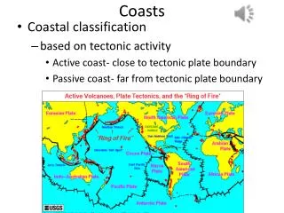
Basic features of the coastal zone • The shoreline is the line that marks the contact between land and sea • The shore extends between the lowest tide level and the highest elevation affected by storm waves • The coast extends inland from the shore as far as ocean-related features are found • The coastline marks the coast’s seaward edge
The shore is subdivided: • The foreshore area is exposed at low tide and submerged at high tide • The backshore area is found landward of the high-tide mark • The nearshore zone lies between the low-tide shoreline and the point where waves break at low tide • The offshore zone is seaward of the nearshore zone
Beaches • A beach is an accumulation of sediment found along the landward margin of an ocean or lake • Beaches are composed of one or more berms (the relatively flat platform composed of sand) • The beach face is the wet sloping surface that extends from the berm to the shoreline • A beach is composed of locally abundant material
The longshore transport system moves sand parallel to the beach Beaches are often called “rivers of sand”
Sand also moves perpendicular to the shoreline • Swash and backwash move sand toward and away from the shoreline • Net loss or gain depends on level of wave activity • Summer typically has light waves and the berm widens • Winter typically has powerful storm waves thaterode the berm
Erosional Shoreline Features • Wave-cut cliffs, wave-cut platforms, and marine terraces • These features originate by the cutting action of the surf against the base of the coast • Wave-cut platforms are flat, bench-like surfaces • An uplifted wave-cut platform is a marine terrace
Erosional Features • Sea arches and sea stacks • Rocks in headlands do not erode at the same rate • Soft and fractured rocks erode faster than hard rocks, forming sea caves • A sea arch forms when two sea caves meet • A sea stack forms when the arch of a sea arch falls
Depositional Coastal Features • Spits, bars, and tombolos • A spit is an elongated ridge of sand extending from the land into the mouth of an adjacent bay • A baymouth bar is a spit that extends across a bay to seal it off from the ocean • A tombolo is a ridge of sand that connects an island to the mainland or another island
Barrier Islands • Barrier islands are low ridges of sand that parallel the coast 3 to 30 kilometers offshore • Found mainly along the Atlantic and Gulf Coastal Plain • Most are 1 to 5 kilometers wide and 15 to 30 kilometers long • Probably form in several ways • Some originate as spits • Some originate from sand piled up offshore • Some are flooded sand dunes from the last glacial period
BARRIER ISLANDS A cross-section profile of a typical undeveloped barrier island with the mainland to the left and ocean to the right.
Georgia’s coast is lined with beautiful barrier islands. Only four of them are accessible by car: Tybee, St. Simons, Sea Island, and Jekyll. The rest are mostly undeveloped and preserved.
Video • Watch the learner.org video on Waves, Beaches and Coasts to see more about shallow water waves • An episode of the “Earth Revealed” series • http://www.learner.org/resources/series78.html
Beach Seasonal Changes • Winter beach (storm beach)—eroded, flat, sediment moved offshore by storm waves • Winter berm—sediment piled on backshore • Summer beach (fairweather beach)—steeper, sediment moved onshore by gentle waves during spring and summer • Summer berm—formed closer to water
Tidal Inlets • Recall flood tides and ebb tides • Water moving in and out of channels between barrier islands (called tidal inlets) also moves sediment in and out of the inlets • The amount of water moving in and out of an inlet is controlled by the tidal range and the size of the water body behind the barrier islands
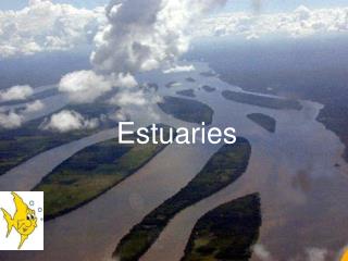
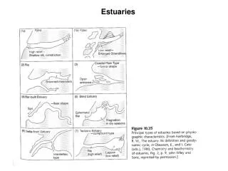
Estuary vs Lagoon • Both are semi-enclosed coastal bays • Estuaries have fresh water input, low salinity • Lagoons have limited fresh water input, often hypersaline • “Sound” is another term for coastal estuary or lagoon behind a barrier island
Little fresh water input Major fresh water input
Isabel Inlet, 17 Sep 2003 Outer Banks of North Carolina Image: 23 Sep 1999 Cape Hatteras
Hurricane Isabel breach, Hatteras Island, NC. Photo taken Sept. 21, 2003. Courtesy Duke University Program for the Study of Developed Shorelines.
Tidal inlets can open and close over time. Usually they are opened during storms, and closed by longshore transport during fair weather.
Changing Sea Level • Sea level rises and falls largely controlled by land ice volume • Glaciation is a time of increasing volume of land ice, thus sea-level fall • Deglaciation is a time of decreasing volume of land ice, thus sea-level rise • We currently are in a period of land ice melting and sea level rise • Sea-level rise becomes a natural hazard when rising water level encroaches upon human development • Difficult for coastal communities to incorporate into planning regulations
Sea-level rise during the past 100+ years has been about 10-15 cm total. Global warming may increase this rate.
Barrier island migration Movement landward over time Associated with rising sea levels Older peat deposits found on ocean beach
How did the Georgia coast end up looking like this? The features in yellow are ancient barrier islands constructed during higher sea levels.
Cross-section of the lower Georgia coastal plain. See how the older the barrier island complexes are, the higher elevation and further inland they are. See ages, elevations, and distance inland on previous slide. Holocene is the name of the current geologic epoch. The Holocene barrier island system is what is active today. From Henry (1968).