Download

1 / 27
270 likes | 275 Vues
Explore the unusual Nyiragongo volcano in Africa and its implications for Earth's history and geology. Discover the unique features of the volcano's lava and its connection to ancient asteroids. Learn about the tectonic plate boundary near Nyiragongo and the formation of a new mantle hotspot.

E N D
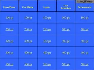
Jeopardy Dynamic Crust Earth’s History Astronomy Meteorology Other $100 $100 $100 $100 $100 $200 $200 $200 $200 $200 $300 $300 $300 $300 $300 $400 $400 $400 $400 $400 $500 $500 $500 $500 $500 Final Jeopardy
Unusual Volcano Nyiragongo, located at 2° S 29° E, is an active African volcano. It has the most fluid lava on Earth. The lava has a composition unlike any other lava in the world. The rare isotopes found in the lava are similar to those found in ancient asteroids. This fact leads scientists to infer that the lava may be as old as our solar system and that it comes from deep inside the mantle near Earth’s outer core. Nyiragongo is one volcano in a ring of many volcanoes surrounding an area that is domed upward nearly a mile above sea level, causing scientists to infer that a new mantle hot spot is forming there. Identify the type of tectonic plate boundary found in the vicinity of Nyiragongo. — an uncertain or complex plate boundary — a divergent plate boundary — rift valley/East African Rift 1 - $100
1 - $200 • Identify a process occurring in the plastic mantle that is inferred to cause tectonic plate motion. — convection — convective circulation — slab pull — subduction — convection currents — magma rising
1 - $300 The data table shows the velocity of seismic S-waves at various depths below Earth’s surface. The graph shows the velocity of seismic P-waves at various depths below Earth’s surface. Letter A is a point on the graph. What property of Earth’s interior causes the S-waves to stop at 2900 km, but allows the P-waves to continue? • S-waves cannot travel through the liquid outer core.
1 - $400 Letters A through G identify rock units and line XY represents a fault. The rocks have not been overturned. What evidence indicates that the folded bedrock is older than fault line XY? — The layers of folded rocks show displacement on both sides of the fault line. — The fault cuts across the folded rocks. — XY cuts across the igneous intrusion which crosscuts the folded rocks.
1 - $500 • Identify the tectonic feature responsible for the formation of the Hawaiian Islands. — Hawaii Hot Spot — mantle hot spot — volcano — a rising magma plume
2 - $100 Which fossil symbol that represents the best index fossil. Describe one piece of evidence shown in the outcrops that indicates that this fossil has characteristics of a good index fossil. CIRCLE — The fossil was found only in the Devonian layer/one layer in each outcrop. — The fossil was geographically widespread. — The fossil indicates a short existence in geologic time/limited time interval.
2 - $200 • Explain why the geologic age of these rock layers could not be accurately dated using carbon-14. — Carbon-14 has a short half-life. — These rock layers are too old to contain measurable carbon-14. — Carbon-14 is used to date recent remains. — No organic material remains in the rock.
2 - $300 The data table shows the radioactive decay of carbon-14 and the age of fossil remains, in years (y). Part of the table has been left blank. — 14N — nitrogen-14/N-14 — nitrogen/N
2 - $400 Indicate the relative ages of geologic features B, E, F, and X, by listing the letters from oldest to most recent. • E, B, X, F
2 - $500 Letters A through G identify rock units and line XY represents a fault. The rocks have not been overturned. Macluritesfossils are found in rock unit F. During which geologic time period were the sediments that formed rock unit F deposited? • Ordovician
3 - $100 • State one factor, other than the tilt of Earth’s axis, that causes seasons to change on Earth. --parallelism of Earth’s axis — The North Pole always points toward Polaris. — revolution of Earth — location of the Sun’s vertical ray — duration/intensity of insolation — angle of insolation
3 - $200 • Using the terms rotation and revolution, explain why the same side of the Moon always faces Earth. — The Moon’s period of rotation equals its period of revolution. — The Moon rotates and revolves once in 27.3 days. — The Moon rotates and revolves at the same rate.
3 - $300 The table below shows times of ocean tides on March 4 for a city on the Atlantic coast of the United States. Determine the time when the next low tide occurred. Include a.m. or p.m. in your answer, if needed and explain why the moon has a greater effect on Earth’s tide than the Sun. • 6:33 p.m. to 6:45 p.m. • Moon is closer than the Sun
3 - $400 The diagram is a model of the sky (celestial sphere) for an observer at 50° N latitude. The Sun’s apparent path on June 21 is shown. Point A is a position along the Sun’s apparent path. Angular distances above the horizon are indicated. Where would the observers shadow be the longest and describe the general relationship between the length of the Sun’s apparent path and the duration of daylight. • Sunrise or sunset • The longer the Sun’s path the more daylight hours.
3 - $500 The table provides information about sunlight received on four dates of a certain year. Letter A represents a date. The arrows indicate the Sun’s direct rays. Identify one possible date represented by letter A AND State the numerical latitude at which the Sun is directly overhead at noon on December 21. Include the units and compass direction in your answer. • March 21 • 23.5 ͦS
4 - $100 Compared to the temperature and relative humidity of the air at point A, describe how the temperature and relative humidity of the air are different as the air arrives at point B. • Temperature – warmer • Relative Humidity- lower/drier
4 - $200 • Explain how the data on the station model indicate a high relative humidity. • The dewpoint and air temperature are nearly the same. • It’s snowing. • 100% cloud cover
4 - $300 Base your answers to the question on the weather graphs below, which show data recorded at Syracuse, New York, as a winter storm moved across the region between December 1 and December 4, 2007. Graph 1 shows air temperatures and dewpoints. Graph 2 shows barometric pressures. State the relationship between the air temperature and the barometric pressure in Syracuse on December 2. — As air temperature increased, barometric pressure decreased. — inverse relationship
4 - $400 Complete the table below by identifying one instrument used to determine barometric pressure and one weather variable determined by using a psychrometer. Barometer — dewpoint — relative humidity — dry-bulb (air) temperature — wet-bulb temperature — air temperature
4 - $500 • State the actual barometric pressure at Oklahoma City. • 1013.4 mb
5 - $100 • At which latitude is Polaris observed at an altitude of 66.5°? 66.5° N -OR- The Arctic Circle
5 - $200 Base your answers to questions 66 through 68 on the data table below, which shows the average carbon dioxide (CO2) concentrations in Earth’s atmosphere for specific years from 1930 to 2010. Carbon dioxide is a greenhouse gas in Earth’s atmosphere that contributes to global warming. The average carbon dioxide concentrations were measured in parts per million (ppm). Calculate the rate of change from 2000 to 2010 of the average carbon dioxide concentrations, in parts per million per year. • 2 ppm/y
5 - $300 The map shows a retreating valley glacier and the features that have formed because of the advance and retreat of the glacier. Describe one piece of evidence likely to be found on the exposed bedrock surfaces that could indicate the direction this glacier moved. — scratches/striations on the bedrock surface — grooves in bedrock — a boulder transported from a more northerly outcrop on the bedrock — an erratic — drumlin
5 - $400 A portion of the land surface shown was recently paved with asphalt and concrete. Describe the change in the amount of runoff and infiltration that will occur. Runoff: — increases Infiltration: — decreases
5 - $500 Identify the latitude and longitude of the eye of Hurricane Wilma on October 24. Label your answer with the correct units and directions. • 27° N 80° W
Final Jeopardy The diagram represents the Moon at eight numbered positions in its orbit around Earth. The nighttime sides of the Moon and Earth are shaded. State the number of days the Moon takes to go through one complete cycle of Moon phases from full Moon to full Moon as viewed from Earth. State the numbered position at which the Moon was located when the photograph was taken. • 29.5 days and #1