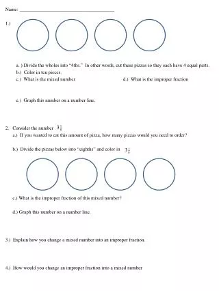
Download
1 / 51
510 likes | 547 Vues
Maritime Economics and Management, The basics

E N D
NAME 457 Maritime Economics and Management Part 1: General Understanding Cdre M Muzibur Rahman, (E), psc, PhD, BN encompasses Maritime managerial aspects for economic development and profit maximization through water borne transportation of goods and passengers, offshore activities, shipbuilding, ship repair/renovations etc. economics and management sea and river ports, Cdre Muzib, psc, PhD
Purview of Maritime economics and management • International trade and seaborne trade • Global trends and impacts on seaborne trade and shipping • Shipping economics • Port economics • Shipbuilding economics • Challenges for shipping and shipbuilding players Key areas: • Economic role of shipping • International transport system • Condition of world merchant fleet • Demand for shipping services • Construction, Rehabilitation and Supply of vessels Cdre Muzib, psc, PhD
Economic role of shipping • Total impact = Direct impact as of economic contribution of the shipping industry itself (40%) + Indirect impact occurs as a result of shipping firms’ expenditure on inputs of goods and services (42%) + Induced impact arises as employees and its supply chain spend their wages on consumer goods and services (18%) • It is done through – contribution to GDP, – payment of tax/VAT and – employment generations Cdre Muzib, psc, PhD
Shipping Equilibrium • In equilibrium, import demand = export supply domestic demand – domestic supply = foreign supply – foreign demand Dd – Sd = Sf – Df If the equilibrium equation is summed up for all countries, the total equilibrium relation is obtained • Therefore, in equilibrium, world demand = world supply Cdre Muzib, psc, PhD
Supply In the short term, supply is finite. Supply curve goes straight up Freight Low Demand: Owners lay up least efficient ships and slow steam Potential tonnage has been put into play, ships operate at full speed S 1 Tonnage As rates rise, Owners bring ships out of layup and increase speed Cdre Muzib, psc, PhD
Demand Freight D 1 Demand is inelastic. If you need a ship, you pay the ongoing rate. S 1 But , if freight goes to “zero”, you will not charter all available tonnage. Tonnage Cdre Muzib, psc, PhD
Supply and Demand D 3 D 1 D 2 Freight As increased demand pushes returns above operating costs, Owners bring more tonnage to market Further demand puts you past the “kink”, rates get volatile due to vertical nature of both supply and demand curve S 1 Tonnage …but rates move slowly Cdre Muzib, psc, PhD
Supply Curve Shifts D 2 D 1 Freight If supply and demand curves meet in this range, rates could remain strong, but…. …an outward shift in the supply curve could bring rates down to the stable, but soft portion of the curve. S 2 S 1 Tonnage Cdre Muzib, psc, PhD
Short vs Long Run Equilibrium Cdre Muzib, psc, PhD
Demand uncertainty for freight index fluctuation Cdre Muzib, psc, PhD
Like any economic aspect ship economics also has three facets: -Global, Macro and Micro Global Issues Northern Hemisphere 80% of the world’s total land area and 91% of the world’s population Land hemisphere Southern Hemisphere Only 20% of the land and 9% of the population Water hemisphere Cdre Muzib, psc, PhD
Population Distribution 75% of world population live within 1000 km of the sea. 85% live in areas less than 500 m above sea-level. 85% live between 20 N – 68 N; less than 10% live in the Southern hemisphere. Sea Level: Mean sea level (MSL) is the datum for measurement of elevation and altitude. It is the equipotential surface of the Earth and normally measured as the mean height of the surface of the sea for all stages of the tide over a 19-year period. During British time, Sea Level/MSL was established at 9 places along the coast of Indian sub-continent. The MSL value at Kiddirpore Docks in Calcutta was then the MSL of the coast of Bangladesh. Thereafter, new MSL was found to be 1.899 meter above the old MSL and it is measured at Sadarghat of Karnafully River, Chittagong. Cdre Muzib, psc, PhD
Economic Importance of Transportation • The ideal transport mode would be instantaneous, free, have an unlimited capacity and always be available. • It would render space obsolete. Practically, this is not the case. Rather space is a constraint for the construction of transport networks. • Transportation appears to be an economic activity different from the others. “It trades space with time and thus money“ [Merlin, 1992]. • Transport is both a factor and a consequence of economic activities, as it – Contributes to the value-added of goods and services; Facilitates economies of scale; Influences land (real estate) value; Participates in the geographic specialization of regions. Cdre Muzib, psc, PhD
Philosophy about sea “Whosoever commands the sea commands trade; Whosoever commands the trade of the world commands the riches of the world, and consequently the world itself.” - Sir Walter Raleigh (1610), English priest and expeditions. Cdre Muzib, psc, PhD
Maritime Transportation • Cheaper means and Economy of Scale – Waterborne transportation provides the cheapest means to carry goods and passengers for the people. For large quantity it provides economy of scale. • High terminal costs – Port infrastructures are among the most expensive to build, maintain and improve. It is costly for shipping companies at first thought. • High inventory costs – Linked to number of heavy industries, e.g. steel, equipment and petrochemicals adjacent to port sites. Cdre Muzib, psc, PhD
Geographical Space of World Maritime Transportation Northwest Gibraltar M Suez Malacca A I P P Panama Sunda Magellan Good Hope Cdre Muzib, psc, PhD
Geographical Space of World Maritime Transportation Sunda Cdre Muzib, psc, PhD
Early European Maritime Expeditions • Christopher Columbus (Italian) tried to find the western route to Asia, but stumbled upon the Americas (in the Bahamas, Cuba and Hispaniola) in 1492. • John Cabot (Italian) would also try to reach Asia in 1497, but was unsuccessful and the coasts of Newfoundland and Labrador of Canada were reached instead. • Vasco da Gama (Portuguese), His initial voyage to India (1497–1499) was the first to link Europe and Asia by an ocean route, connecting the Atlantic and the Indian oceans. This is widely considered a milestone in world history, as it marked the beginning of a sea-based phase of global multiculturalism. • In 1519, Ferdinand Magellan (Portuguese) embarked in an expedition to find the western maritime route to Asia. He successfully reached the Pacific Ocean by rounding the southern tip of South America (1520) and by going through the strait that would later bear his name. After crossing the Pacific Ocean he was killed in 1521 in Southeast Asia. However, one of his ships made the trip back to Europe through the Cape of Good Hope and completed the first round-the-world journey in history (1522). • Encouraged by this success, Spain conquered the Philippines between 1565 and 1571 and established their colonial capital at Manila. Cdre Muzib, psc, PhD
Early European Maritime Expeditions 370 leagues Cape Verde Gama (1497-99) Treaty of Tordesillas Line (1494) Cdre Muzib, psc, PhD
Colonial Trade Pattern By the early 18th century, a complex network of colonial trade was established over the North Atlantic Ocean. This network is partially the result of local conditions and of dominant wind patterns. It was discovered in the 15th century, notably after the voyages of Columbus, that there is a circular wind pattern over the North Atlantic. The eastward wind pattern, which blows on the southern part, came to be known as the trade winds since they enabled to cross the Atlantic. The westward wind pattern, blowing on the northern part, came to be known as the westerlies. Cdre Muzib, psc, PhD
Colonial Trade Pattern Since sail ships were highly constrained by dominant wind patterns, trade followed. Manufactured commodities were exported from Europe, some towards the African colonial centers, some towards the American colonies. This system also included the slave trade, mainly to Central and South American colonies (Brazil, West Indies). Tropical commodities (sugar, molasses) flowed to the American colonies and to Europe. North America also exported tobacco, furs, indigo (a dye) and lumber (for shipbuilding) to Europe. This system of trade collapsed in the 19th century with the introduction of steam ships, the end of slavery and the independence of many of the colonies of the Americas. Cdre Muzib, psc, PhD
Colonial Trade Pattern, North Atlantic, 18thCentury 1) Sugar, Molasses, Slaves 2) Flour, Meat, Lumber Europe North America North Atlantic Ocean 1 2 Africa West Indies Dominant wind South America Trade Route 0 500 1,000 2,000 3,000 Miles Cdre Muzib, psc, PhD
The Industrial Revolution and Marine Transportation (1800-1870) Massive modifications of transport systems occurred with two major phases: the first centered along the development of canal systems; the second centered along railways. This marked a new era in the mechanization of interconnected land and maritime transport systems. Cdre Muzib, psc, PhD
Major Straits of The Globe Name Bab-el-Mandeb Strait Bass strait Bering Strait Bonne-Fasio Strait Bosporous Strait Cook Strait Dardenleez Strait Davis strait Denmark strait Dover strait Florida Strait Gibraltar Strait Hormuz strait Hudson strait Magellan strait Joins Red Sea & Gulf of Aden Location Yemen-Djibouti Tasman Sea & South Sea Bering Sea & Chuksi Sea Mediterranean Sea Black Sea and Marmara Sea South Pacific Ocean Marmara Sea and Aegean Sea Baffin Bay & Atlantic Ocean North Atlantic and Arctic Ocean English Channel & North Sea Gulf of Mexico and Atlantic OceanUSA-Cuba Mediterranean & Atlantic Gulf of Persia & Gulf of Oman Gulf of Hudson & Atlantic Ocean Canada Pacific and South Atlantic Ocean Chile Australia Alaska-Russia Corsika-Sardinia Turkey New Zealand (N & S islands) Turkey Greenland-Canada Greenland-Iceland England-France Spain-Morocco Oman-Iran Cdre Muzib, psc, PhD
Name Makkassar Strait Malacca Strait Mesina Strait Mozambique Strait Indian Ocean North Channel Otranto Strait Palk Strait Sunda Strait Tatar Strait Joins Java Sea & Celebeze Sea Andaman Sea & South China Sea Indonesia - Malaysia Mediterranean Sea Location Indonesia Italy-Sicily Mozambique - Malagasy Ireland-England Italy-Albania India-Sri Lanka Indonesia Russia (E Island) Papua New Australia Japan (Hokkaido-Honshu island) Mexico-Cuba Irish Sea & Atlantic Ocean Adriatic Sea & Ionian Sea Palk Bay & Bay of Bengal Java Sea & Indian Ocean Japan Sea & Okhotsk Sea Russia-Sakhalin Taurus Strait Arafura Sea & Gulf of Papua Guinea - Tsungaru Strait Japan Sea and Pacific Ocean Yucatan Strait Gulf of Mexico and Caribbean Sea Cdre Muzib, psc, PhD
Strait of Malacca Cdre Muzib, psc, PhD
Strait of Malacca & Sunda Cdre Muzib, psc, PhD
Strait of Formosa (Beautiful) Cdre Muzib, psc, PhD
Emergence of Modern Marine Tpt Systems Global maritime circulation was dramatically improved when infrastructures to reduce intercontinental distances, such as the Suez (1869) and the Panama (1914) canals were constructed. Canals are built to carry goods by boat from one place to another. On the other hand, rivers are formed at a source such as a natural spring or a glacier and flow down the land to the sea. The Suez Canal Cdre Muzib, psc, PhD
Suez Canal Cdre Muzib, psc, PhD
Geo-Economic Impact of Suez Canal 10,000 KM 16,000 KM Cdre Muzib, psc, PhD
Geo-Economic Impacts of the Suez Canal Planned by the French but constructed by the British, the Suez Canal opened in 1869. It connects Red sea and Mediterranean sea and represents, one of the most significant maritime "shortcuts" ever built. It brought a new era of European influence in Asia by reducing the journey (blue line) from Europe to Asia by about 6,000 km (around Africa; red line). The region became commercially accessible and colonial trade expanded. Great Britain, the maritime power of the time, benefited substantially from this improved access. For instance, the Suez Canal shortened the distance on a maritime journey from London to Bombay by 41% and from London to Shanghai by 32%. Cdre Muzib, psc, PhD
Panama Canal Cdre Muzib, psc, PhD
Panama Canal (Atlantic Ocean access) Cdre Muzib, psc, PhD
Panama Canal (Pacific Ocean access) Cdre Muzib, psc, PhD
Geo-Economic Impact of Panama Canal NORTH AMERICA Atlantic Ocean 8,000 KM Panama Canal SOUTH AMERICA Pacific Ocean 21,000 KM Cdre Muzib, psc, PhD
Geo-Economic Impact of Panama Canal • Panama Canal connects two ocean Atlantic and Pacific. • 48 mile (77 km) waterway • Its work was completed in 1914 • It considerably shortens the maritime distances between the American East and West coasts by a factor of 13,000 KM. Cdre Muzib, psc, PhD
Types of Maritime Routes Port-to-Port Pendulum Round-the-World Cdre Muzib, psc, PhD
Types of Maritime Routes • Port-to-port. Involves a more or less regular service between two ports, often moving back and forth, but very likely the flow of freight is unidirectional. This system has the disadvantage of offering limited connectivity movements of raw materials, notably oil and minerals, between zones of extraction and industrial regions. • Pendulum. Involves a regular itinerary between a sequence of ports, often serviced by geographical proximity. A set of ports along one seaboard are serviced and then an ocean is crossed and the process is repeated along another seaboard. This is notably the case between Western Europe and the Eastern Seaboard of the United States. This type of route is more characterizing cargo, notably containerized cargo. • Round-the-World. Involves servicing continuously a sequence of ports, often in both directions, so that sequence enables a round trip around the world. A limited amount of ports per continent are serviced. This type of maritime route strictly concerns container shipping. Cdre Muzib, psc, PhD and mainly represents
Maritime Enclaves and Accessibility Less than 700 km More than 700 km Maritime Enclave Cdre Muzib, psc, PhD