Download
1 / 30
310 likes | 422 Vues
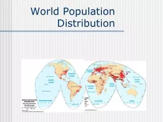
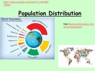
Population Distribution. United States And Canada. CANADA. Saint Lawrence Iroquoian – Kanata “Village” 1931 Statute of Westminster 3,851,807 Square miles Population – 34,207,000(35 th ) – 8.88/square mile – 90% within 100 miles of US

E N D
Population Distribution United States And Canada
CANADA Saint Lawrence Iroquoian – Kanata “Village” 1931 Statute of Westminster 3,851,807 Square miles Population – 34,207,000(35th) – 8.88/square mile – 90% within 100 miles of US Ethnic Groups – European(76.7%), Asian(14.2%), Native(4.3%), Black(2.9%) Languages – English 59.3%; French 23.2% Religion – Roman Catholic(42.6%) Protestant(23.3%) Muslim(1.9%) Capital – Ottawa GDP - $44,650(9th)
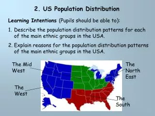
Canada’s Physical Regions • The Cordillera • The Plains • The Shield • The North • Great Lakes St. Lawrence • The Atlantic Region
CORDILLERA • The Cordillera is located on the west coast of Canada and includes British Columbia, the Yukon, southwest Alberta and part of North West Territories. The climate of the Cordillera’s coast is mild, wet and rarely has snow that stays. The interior of the Cordillera is usually colder and dryer with larger amounts of snow. In the summer, it is warmer and there is less rain. The landscape of the Cordillera has long chains of high rugged mountains. This includes the Rocky Mountains and the Coastal Mountains. Parts of this region are covered with forests.
THE PLAINS • the Interior Plains is a region with fields of grain or grasslands. It is mainly flat with a few rolling hills.
THE SHIELD • In the Canadian Shield there are lots of trees and rocks. The rocks in this region are old, for they were formed millions of years ago. The region is full of igneous rock, which later turned into metamorphic rock. The region is well above sea level, as it is in a very mountainous area. The mountains, though, have been slowly eroded over the years. Erosion of these mountains has deposited many materials. The barren rock in this region has left all of the valuable materials inside exposed.
THE NORTH • This is the only landscape where there is permafrost . In the summer the top layer of the landscape may thaw and this often forms lakes or swamps. Icecaps or glaciers, fjords, barren tundra, pingos (huge mounds of solid ice ) tree line, northern lights (aurora borealis) and the polar ice pack (permanently frozen sea ice) are just a few of the unique features found in this landscape.
GREAT LAKES ST. LAWRENCE • Lowland region including flat and rolling hills The Great Lakes (Lake Huron, Lake Erie, and Lake Ontario) St. Lawrence River or Seaway Rich soils of clay, sand, and gravel
THE ATLANTIC REGION • A diversity of physical features — wooded uplands, fertile lowlands, and an 11,200-kilometres-long shoreline — endow this ecozone with incomparable beauty.
USA Italian Explorer Amerigo Vespucci Declared 1776 – Recognized 1783 3,717,811.29 Square Miles Population – 309,975,000(3rd) – 83.8/square mile, 80% live in cities Ethnic Groups – White(62.6), Hispanic(17.1), Black(13.2), Asian(5.3), Native(1.2) Languages – English(82.1), Spanish(10.7) Religion – Protestant(52), Catholic(24), Mormon(1.7), Jewish(1.7), Muslim(.7) Capital – Washington D.C. GDP - $54,980(7th)
PACIFIC NORTH WEST • In general, the Pacific Northwest has a wet and cool climate which has led to the growth of extensive forests featuring some of the largest trees in the world. The region's coastal forests are considered temperaterainforests. More inland however, the climate can be drier with more harsh winters and warmer summers. There are four mountain ranges dominating the Pacific Northwest. They are the Cascade Range, the Olympic Range, the Coast Range and parts of the Rocky Mountains
PACIFIC SOUTH WEST • The climate of the Southwest is varied. It can be warm and rainy, below freezing, or hot and dry. Many parts of the Southwest are covered by deserts--dry lands that get less than 10 inches of precipitation each year
ROCKY MOUNTAINS • The Rocky Mountains are located in western North America. They are know for their beautiful scenery with mountains, trees and big game. People visit the Rockies for many recreational activities like hiking, hunting, camping, skiing and lots of other sports. • The Rocky Mountains have unpredictable weather which can change rapidly. As with other highland climates, the climate changes with increasing altitude. In general, the Rockies have mild summers, cold winters and a lot of precipitation.
GREAT PLAINS • The Great Plains is a vast expanse of grasslands stretching from the Rocky Mountains to the Missouri River and from the Rio Grande to the coniferous forests of Canada—an area more than eighteen hundred miles from north to south and more than five hundred miles from east to west. The Great Plains region includes all or parts of Texas, New Mexico, Oklahoma, Kansas, Colorado, Nebraska, Wyoming, South Dakota, North Dakota, Montana, Alberta, Saskatchewan, and Manitoba. The region, once labeled "the Great American Desert," is now more often called the "heartland," or, sometimes, "the breadbasket of the world."
MISSISSIPPI VALLEY • The largest forested wetland ecosystem in North America. This 22 million acre floodplain extends from the confluence of the Mississippi and Ohio Rivers at Cairo, Illinois, to the northern Gulf of Mexico, with a drainage basin encompassing 41% of the conterminous United States. The topographically complex floodplain features a mosaic of ridges, swales, meander belts and back swamps that supports a diverse and ecologically rich forested wetland ecosystem – one of the most productive in North America.
GREAT LAKES • The Great Lakes basin is home to more than one-tenth of the population of the United States and one-quarter of the population of Canada. Some of the world's largest concentrations of industrial capacity are located in the Great Lakes region. Nearly 25 percent of the total Canadian agricultural production and 7 percent of the American production are located in the basin. The United States considers the Great Lakes a fourth seacoast, and the Great Lakes region is a dominant factor in the Canadian industrial economy.
SOUTH EAST • The climate of the Southeast is uniquely warm and wet, with mild winters and high humidity, compared with the rest of the continental United States.
MID ATLANTIC • The region’s relatively large population (15 percent of the nation’s population in 5 percent of the contiguous land area) and economic development have stressed many of its ecological resources, particularly the nation’s two largest estuaries: the Chesapeake Bay and Albemarle-Pamlico Sounds. These estuaries, along with the Delaware River basin, are stressed by nutrient runoff from agricultural and urban areas. The region’s forests, wetlands, and fresh water streams are affected by habitat loss and degradation, pollution and nonnative invasive species.
NORTHEAST • Home to striking natural beauty. Composing it are massive, bald-topped mountains, lush lowland forests, rocky storm-wracked coasts and everything from tiny wintergreen herbs to titanic moose
BERMUDA Established – 1707 British Colony Square Miles – 20.6 Population – 64,237, 3,293/square mile Ethnic Groups – Black(54%), White(31%), Multi(8%), Asian(4%) Languages – English, Portuguese, Spanish Religion – Protestant(44%), Catholic(15%) Capital – Hamilton GDP – 84,460.33
GREENLAND Established 1814 – Denmark 836,109 Square miles Population – 56,968, .069/square mile Ethnic Groups – Greenlandic(89%), European(11%) Languages – Greenlandic, Danish Religion – Mostly Lutheran Capital – Nuuk (25% of the population) GDP - $37,009.041
Explain the runoff-based approach. Explain the different approach that Jawitz and Padowski took in their study. Explain the findings of the Jawitz and Padowski study. Explain what a stressed watershed is. What are some of the constraints on water availability in the southwest? Based on the two articles what are some ideas that could help prevent the water supply from diminishing?