Download
1 / 23
240 likes | 375 Vues
Entering A New Landsat Era – The Future is Now. Tom Loveland U.S. Geological Survey Earth Resources Observation and Science Center (EROS) Sioux Falls, SD 57198. Entering A New Landsat Era – The Future is Now. This presentation uses LANDSAT data. Tom Loveland U.S. Geological Survey

E N D
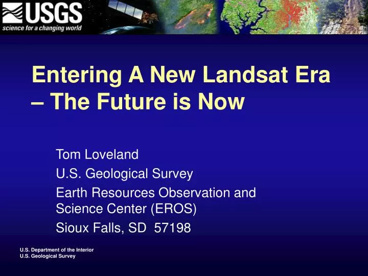
Entering A New Landsat Era – The Future is Now Tom Loveland U.S. Geological Survey Earth Resources Observation and Science Center (EROS) Sioux Falls, SD 57198
Entering A New Landsat Era – The Future is Now This presentation uses LANDSAT data Tom Loveland U.S. Geological Survey Earth Resources Observation and Science Center (EROS) Sioux Falls, SD 57198
36+ Years of Continuous Landsat Global Land Observation • Landsat 1 was launched July 23, 1972 (MSS) • Landsat 2 was launched January 22, 1975 (MSS) • Landsat 3 was launched March 5, 1978 (MSS) • Landsat 4 was launched July 16, 1982 (TM) • Landsat 5 was launched March 1, 1984 (TM) • Landsat 6 was launched October 5, 1993, but never reached orbit • Landsat 7 was launched April 15, 1999, May 2003 SLC-Off (ETM+) http://landsat.usgs.gov/about_landsat1.php
Major changes and improvements are ahead… • NASA and the USGS are developing the Landsat Data Continuity Mission (LDCM), which will further extend the global land record. • The USGS will soon be making the entire 36-year long Landsat archive available to anyone via the Internet at no cost. • The opening of the Landsat archive and the continuation of the Landsat record is a revolution that will affect the future of moderate resolution Earth observations.
“The opening of the Landsat archive to free, web-based access is like giving a library card for the world’s best library of Earth conditions to everyone in the world.”Adam Gerrand, FAO Forest Resources Assessment
Landsat Contributions to the U.S. Climate Change Science Program • Landsat data are particularly important for environmental change research because they provides a common time series of land cover condition, starting in 1972, for nearly the entire Earth's terrestrial surface. • One of the great challenges is how to relate human incentives, behavior and action at particular localities to land cover change at broader geographic regions. The fine spatial resolution of Landsat images along with its global geographic extent provides the necessary data for making this linkage.
Driving the need for Landsat… • Science – understanding a changing planet • Operational applications – managing and monitoring resources for economic and environmental quality, public health and welfare, and national security • Both require: • A global perspective • A long-term record of observation • Huge amounts of well-calibrated data
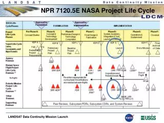
The timeline for no-cost access to the entire Landsat archive…
Meeting the needs of users… • There are over 2 million Landsat scenes in the USGS archive • Over 150,000 processed Landsat scenes can be stored on-line for immediate download • Other archive Landsat data can be readily processed at a current rate of >1200 images per day.
Initial experience - significant demand… • Fiscal Year (FY) 2001 - 19,300 Landsat 7 images were distributed to users. • In FY2008 more than 86,000 Landsat 7 images were distributed at no charge as part of the “web-enabling” pilot. • Only SLC-off Landsat 7 images over the U.S. were available through the pilot. • In October 2009, over 60,000 Landsat 7 images (from the entire Landsat 7 archive of more than 850,000 scenes) have been downloaded.
How will the opening of the Landsat archive and the continuation of the Landsat record revolutionize the future of moderate resolution Earth observations?
No-cost data puts funds back into science and applications project budgets The USGS National Land Cover Database (NLCD) requires at least 2 scenes per path/row (820 Landsat scenes) for conterminous US land cover mapping. The cost of data is at least $656,000 per update. Money used for Landsat image purchases can now be used to expand research and applications
Exploiting free Landsat data – National Land Cover Mapping • Many national land cover agencies (e.g., Natural Resources Canada, Mexico INEGI, European Environmental Agency, Australia National Land and Water Audit) use Landsat as the primary source for national land cover mapping. • Landsat data can cost each program nearly $1 million per mapping cycle. • Now each agency can consider previously unaffordable enhancements or accelerated mapping schedules
Remote sensing research has shown that the use of additional temporal data improves the accuracy and utility of derived data sets, which will lead to expanded applications. Historically, most Landsat data users were limited to the data they could afford - rather than the data they needed. Wildfire modeling
Forest cover studies over persistently cloudy regions – the Central African Regional Program for the Environment example Single Landsat scene coverage: 104 scenes ($83,200) With single scenes, cloud cover makes tropical forest monitoring nearly impossible Hansen, et al. 2008
Adding 3-5 images per path/row clears most clouds – but this has been cost prohibitive 416 scenes ($332,800) Hansen, et al. 2008
Result of additional temporal Landsat coverage – improved forest cover mapping Hansen, et al. 2008
Opportunities for new land management applications that are relevant at local scales MODIS (1 km) Landsat (60 m) Multi-scale Drought Monitoring JUNE 2002 GOES Evaporative Stress Index (Source: Martha Anderson, USDA ARS)
No-cost Landsat data makes operational monitoring of land change feasible - Landsat-calibrated change estimates for Humid Tropics biome (Hansen et al., 2008)
New opportunities for expanding the geographic scope of land cover investigations No cost Landsat is enabling the International Water Management Institute to launch an effort to upgrade global irrigated area maps to 30m2 resolution (Prasad Thenkabail)
FAO Forest Resource Assessment 2010 Remote Sensing Sampling Framework • Wall to wall MODIS (250m), plus LANDSAT (30m) at 1 degree: 10 km x 10 km • ➾ ~ 13 000 sampling sites (excluding poles and deserts) • ➾ Sampling intensity: about 1 % ( 1.2 % of land surface)
Moving toward operational land monitoring… • Land monitoring products are needed a wide range of scientific and applied programs. • Affordable access to a continuing flow of Landsat and other data is essential. • Free access to Landsat data eliminates the major barrier to near-real time land monitoring needed for scientific and operational applications.
Looking to the future… • Continue improving access to the Landsat archive • Provision of advanced land monitoring products • Successful and on time launch of LDCM • Make Landsat program operational – as envisioned in Future of Land Imaging report