Download
1 / 33
401 likes | 773 Vues
Drifting Continents and Spreading Seas The Road To Plate Tectonics. Alfred Wegener and the Continental Drift hypothesis:. Up until the early 1900s, long-held tradition in the earth sciences stated that continents have remained in fixed positions throughout geologic time

E N D
Drifting Continents and Spreading Seas The Road To Plate Tectonics
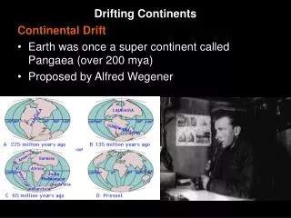
Alfred Wegener and the Continental Drift hypothesis: • Up until the early 1900s, long-held tradition in the earth sciences stated that continents have remained in fixed positions throughout geologic time • In 1926, Wegener refuted this idea, suggesting that continents once had fit together in a “SuperContinent” called Pangaea • Pangaea > Greek for “all land” • Wegener’s idea was largely dismissed by the scientific establishment for lack of a mechanism that could drive the movement of continents • He also predicted that North America and Europe were moving apart at 30m/yr. This is about 1000x too fast!
What evidence did Wegener have to support his hypothesis? 1. Fit of the continents Scholars and cartographers as early as the 1500s saw that Africa appeared to tuck in neatly against the coasts of North and South America In fact, all of the continents can be arranged to join with nearly no overlap or gaps. Coincidence? Wegener thought not.
What other evidence did Wegener have to support his hypothesis? 2. Location of past glaciations at ~300 Ma The passage of a glacier causes deep grooves to be carved into underlying rocks, called STRIATIONS. These point along the direction of travel of the glacial ice Glaciers also leave behind a distinctive sediment type, called TILL. Using the distribution of till and striations that were created ~300 million years ago, Wegener saw that South America, southern Africa, India, Australia and Antarctica all experienced a glaciation. Today, these places are widely separated and tropical. The striations pointed to a common center of the glacial ice cap
What other evidence did Wegener have to support his hypothesis? 3. Distribution of tropical climates at ~300Ma Rock types such as coals, evaporite minerals (salts), desert sand dunes and reefs built by coral-like organisms indicate a tropical climate. Wegener’s reconstruction of Pangea, together with his evidence of glaciation, predicted that tropical climate should have extended in a belt across southern North America and Europe and northern South America and Africa about 300 million years ago. These rock types are found exactly within the belt predicted by Wegener’s hypothesis
What other evidence did Wegener have to support his Hypothesis? 4. Distribution of fossils at ~300 Ma Today, certain animals and animals live only on certain continents. Many fossil animals and plants exhibit a similarly restricted geographic range. If continents were all joined ~300 Ma (million years ago), then this would have provided an opportunity for plants and animals to disperse among joined continents. Once continents drifted apart, similar species would then be separated by large expanses of uncrossable ocean. This is seen in several animal (Cynognathus, Lystrosaurus) and plant (Glossopteris) species
What other evidence did Wegener have to support his Hypothesis? 5. Matching rock units and Mountain Belts Geoscientists can recognize particular and distinctive rocks that were created all at the same place and at the same time. Wegener recognized several such assemblages of rock, now separated by ocean basins. #1 – in both South American and Africa #2 – in a belt along the east coast of North America and Greenland, and along the west coast of Africa, Great Britain and Scandinavia
What evidence did Wegener have to support his hypothesis? • Fit of the continents • Location of past glaciations • Distribution of tropical climates • Distribution of fossils • Matching of rock units across ocean basins • Wegener hypothesized that • Continents may move because of Earths rotation • Continents ‘plow’ through oceanic crust like a ship through water • But Was it Enough? . . . No! • Studies showed that the forces from rotation of the Earth were ~1 million times to small to move large continents • Continental crust (?) is weaker than oceanic crust (?)
Paleomagnetism, Polar Wander, and Direct Evidence of Sea-Floor Spreading
Earth’s Magnetic Field - Declination Earth’s magnetic field poles also do not completely coincide with the true geographic N & S poles. Today, the magnetic pole sits ~ 11° off of the geographic pole We call this horizontal angle the magnetic declination Thus, declination involves ONLY the horizontal component of the Magnetic field
Earth’s Magnetic Field Because the geodynamo in liquid outer core that generates Earth’s magnetic field is deep within the planet, Lines of magnetic force run at an angle compared to earth’s surface. At the equator, the magnetic field is completely horizontal At the N & S magnetic poles, the field is entirely vertical At mid-latitudes, the magnetic field is tilted. Earth’s Magnetic Field is 3-Dimensional!!! This angle is called magnetic inclination.
Earth’s Magnetic Field Many rocks contain minerals which are slightly magnetic Example: the rock “lodestone” contains the mineral magnetite (Fe3O4). Igneous rocks (generated by cooling and solidifying a melted magma or lava) commonly contain such minerals. (Some Sedimentary rocks have them too) When the magma or lava cools, it’s magnetic minerals align with the earth’s magnetic field. In this way, igneous rocks inherit earth’s magnetic field at their time of formation. We can measure the weak magnetic fields in igneous rocks.
Earth’s Magnetic Field Other rocks pick up signatures of earth’s magnetic field through: • alignment of magnetic minerals during deposition of sediments • alignment of magnetic minerals precipitated during alteration/ • recrystallization caused by moving groundwater
Earth’s Magnetic Field We use both the measured declination and inclination to determine the location of an ancient magnetic pole (a paleopole) in a rock. Today: in Boone, declination is -6.99°, and inclination is 64.81° Last Year: declination -6.92°, and inclination is 64.91° Further north, the inclination angle is greater (north Quebec = ~77°), further south it is smaller (Miami = ~54°) What might it mean if a rock from western NC dated at 100 Ma had an inclination of ~50°? http://www.ngdc.noaa.gov/geomagmodels/IGRF.jsp
Earth’s Magnetic Field What might it mean if a rock from western NC dated at 100 Ma had an inclination of ~50°? Either the pole has moved, or the land has moved. Which is it? Inclination in ancient rocks tells us the apparent distance (in latitude) between the site where the rock was formed and the magnetic north pole Declination in ancient rocks tells us which direction pointed to the north magnetic pole when the rock formed (and thus give E-W distance, or longitude) So, to find the paleo magnetic poles or a specific location, you need both inclination and declination.
Earth’s Magnetic Field Using the magnetism recorded in ancient rocks, we can construct a history of how the magnetic poles have moved relative to a rock unit through time . . . (or is it how the rock has moved relative to the magnetic poles through time?)
Earth’s Magnetic Field Using the magnetism recorded in ancient rocks, we can construct a history of how the magnetic poles have moved relative to that rock through time (or is it how the rock has moved relative to the magnetic poles through time?)
Earth’s Magnetic Field At first, this behavior of apparent polar wander was thought to indicate moving magnetic poles relative to fixed continents. But then, scientists compared polar wander paths from multiple continents, and they did not match.
Earth’s Magnetic Field The polar wander paths for Europe and North America can be aligned if we proposed that these two continents were once connected, and then they separated about 180 Ma
Earth’s Seafloor Bathymetry Bathymetry – The topography of the sea floor WWII brought about the need for detailed maps of the sea floor much like topography describes details of land surface bathymetry describes details of the seafloor surface
Earth’s Seafloor Bathymetry • With WWII came recognition of three key features of seafloor bathymetry: • Mid-Ocean Ridges. Sharp ridges rising to within 2-2.5 km below sea level run across ocean basins, rising sharply from flat abyssal plains more than 4 km below sea level. • Deep-Ocean Trenches. Along the perimeter of several ocean basins are narrow, elongated trenches reaching 8-12 km below sea level, many of which are adjacent to arcs of islands with active volcanoes. • Fracture Zones. Many ocean basins are cut by narrow bands of fractures that run approx. perpendicular to the ridges, and appear to segment the ridges into many small, offset pieces.
Earth’s Seafloor Bathymetry • Geologists discovered that oceanic crust is very different than what is found on the continents • Sediment. Much of the seafloor is coated with a fine layer of sediment, that varies from km in some coastal areas to nearly zero thickness along the mid-ocean ridges. • Basalt and Gabbro. Oceanic crust contains no felsic/silicic rocks (granite) and no metamorphic rocks. • Heat Flow. More heat seems to rise up through the oceanic crust along these ridges, and much less elsewhere. This derives from the presence of hot magma very close to the surface along ridges. • Submarine Earthquakes. Earthquakes on the seafloor are not distributed randomly, but occur along the ridges and trenches.
Earth’s Seafloor Spreading Harry Hess (1906-1969) In the 1950s, Harry Hess, a Princeton geologist, looked at these features of the seafloor, and reasoned that new oceanic crust was created at ridges and consumed at trenches – this was called sea floor spreading. …Formation of Ocean Crust Animation…
Earth’s Seafloor Spreading At about the same time, detailed mapping of magnetism recorded in rocks of the seafloor showed that these rocks record reversals in the strength and direction of earth’s magnetic field
Earth’s Seafloor Spreading If Hess was correct in saying that sea floor spreading was occurring at mid ocean ridges… The patterns of magnetic anomalies should be symmetrical. They Are Symmetrical! Harry Hess - Illustrating his sea floor spreading hypothesis
Earth’s Magnetism and Seafloor Spreading Scientists who study paleomagnetism have discovered that both the strength and the polarity of earth’s magnetic field have changes through time. We call these episodes of polarity “chrons”, with short episodes called “subchrons” Roughly every 600,000 years (but not regular in schedule), Earth’s magnetic field weakens and then switched polarity. Magnetic North becomes South, and vice versa.
Earth’s Magnetism and Seafloor Spreading Scientists who study paleomagnetism have discovered that both the strength and the polarity of earth’s magnetic field have changes through time. We call these episodes of polarity “chrons”, with short episodes called “subchrons” Roughly every 600,000 years (but not regular in schedule), Earth’s magnetic field weakens and then switched polarity. Magnetic North becomes South, and vice versa.
Earth’s Magnetism and Seafloor Spreading Detailed measurement of the magnetic field in the igneous rocks of the seafloor reveals a curious pattern. Each mid-ocean ridge is lined by mirror-image patterns of magnetic anomalies and magnetic field reversals
Earth’s Magnetism and Seafloor Spreading The age of these seafloor rocks is well-constrained, and documents seafloor spreading At ~ 1cm/yr in the Atlantic And ~ 10cm/yr in the Pacific So, Wegener and Hess were right!