Download
1 / 1
20 likes | 163 Vues
Zone A ----Greatest Hazard Zone B Zone C Zone D ---- Least Hazard. Regional Case Study III: Seismic Hazards in the Portland Area. By Alyssa Pratt, Earth Science Major, Western Oregon University, Monmouth, OR 97361, arpratt06@wou.com. 1. 4b. 3. 4c. Abstract. Sources of Seismic Hazards.

E N D
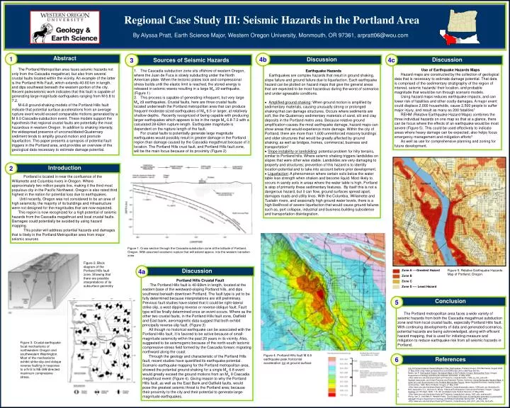
Zone A ----Greatest Hazard Zone B Zone C Zone D ---- Least Hazard Regional Case Study III: Seismic Hazards in the Portland Area By Alyssa Pratt, Earth Science Major, Western Oregon University, Monmouth, OR 97361, arpratt06@wou.com 1 4b 3 4c Abstract Sources of Seismic Hazards Discussion Discussion The Portland Metropolitan area faces seismic hazards not only from the Cascadia megathrust, but also from several crustal faults located within the vicinity. An example of the latter is the Portland Hills Fault, which extends 40-60 km in length, and dips southwest beneath the western portion of the city. Recent paleoseismic work indicates that this fault is capable of generating large-magnitude earthquakes ranging from M 6.8 to 7.2. M-6.8 ground-shaking models of the Portland Hills fault indicate that potential surface accelerations from an average rupture event would exceed comparable motions generated by a M 9.0 Cascadia-subduction event. These models support the hypothesis that regional crustal faults are potentially the most hazardous in western Oregon. In addition to shaking intensity, the widespread presence of unconsolidated Quaternary sediment tends to amplify ground motion and promote liquefaction. This paper presents a synopsis of potential fault triggers in the Portland area, and provides an overview of the geological data necessary to estimate damage potential. Use of Earthquake Hazards Maps Hazard maps are constructed by the collection of geological data that is necessary to estimate damage potential. That data is comprised of the sedimentary stratigraphy of the region of interest, seismic hazards/ their location, and probable magnitude that would be run through scenario models. Using hazard maps reduces earthquake impacts, and can lower risk of fatalities and other costly damages. A major event could displace 2,000 households, cause 2,500 people to suffer major injury, and result as many as 200 fatalities1 REHM (Relative Earthquake Hazard Maps) combines the three individual hazards on one map so that at a glance, there can be focus where the effects of an earthquake would be most severe (Figure 5). This could be used effectively to indicate areas where heavy damage can be expected; also helps focus emergency management and mitigation efforts3 As well as use for comprehensive planning and zoning for future development. • Earthquake Hazards • Earthquakes are complex hazards that result in ground shaking, slope failure and ground failure due to liquefaction. Each earthquake hazard can be plotted on hazard maps that give the general areas that are expected to be most hazardous during the worst of scenarios and under agreeable conditions. • Amplified ground shaking: When ground motion is amplified by sedimentary materials, causing unusually strong or prolonged shaking that can damage structures. Occurs where sediments are soft, like the Quaternary sedimentary materials of sand, silt and clay deposits in the Portland metro area. Because relative ground amplification causes the most earthquake damage, hazard maps can show areas that would experience more damage. Within the city of Portland, there are more than 1,600 unreinforced masonry buildings and older structures that would be greatly affected by ground shaking; as well as bridges, homes, commercial, business and transportation1 • Slope instability or landsliding: potential problem for hilly terrains, similar to Portland hills. Where seismic shaking triggers landslides on slopes that were other wise stable. Landslides are very damaging to property and structures; prevention of this hazard is to identify location potential and to take into account before prior development. • Liquefaction: A phenomenon where certain soils below the water table lose strength when shaken and become liquid. Most likely to occurs in sandy soils in areas where the water table is high, Portland is atop of primarily these sedimentary features. By itself this is not a dangerous hazard, but it can flow, ground surfaces spread apart, damages roads and utility lines. With the Columbia, Willamette and Tualatin rivers, and seasonally high ground water levels, there is a high likelihood of severe liquefaction that would cause ground failures such as, port collapse, industrial and business building subsidence and transportation disintegration. • The Cascadia subduction zone sits offshore of western Oregon, where the Juan de Fuca is slowly subducting under the North American plate. When the tectonic plates lock and compressional stress builds until the elastic limit is reached, the stored energy is released in seismic waves resulting in a large Mw ≥9 earthquake. (Figure 1) • This process is capable of generating infrequent, but very large Mw ≥9 earthquakes. Crustal faults, here are three crustal faults located underneath the Portland metropolitan area that can produce frequent moderate sized earthquakes of Mw6.5 or larger, at relatively shallow depths. Recently recognized of being capable with producing larger earthquakes which appears to be in the range Mw 6.8-7.2 with a calculated 28-62km rupture length. Earthquake magnitude is dependent on the rupture length of the fault. • For crustal faults to potentially generate large magnitude earthquakes would possibly result in greater damage in the Portland region than damage caused by the Cascadia megathrust because of it location. The Portland Hills crust fault, and Portland Hills fault zone, will be the main focus because of its proximity (Figure 2) 2 Introduction Portland is located in near the confluence of the Willamette and Columbia rivers in Oregon. Where approximately two million people live, making it the third most populous city in the Pacific Northwest. Oregon is also rated third highest in the nation for potential loss due to earthquakes. Until recently, Oregon was not considered to be an area of high seismicity, the majority of its buildings and infrastructure were not designed for the magnitudes that are now expected. This region is now recognized for a high potential of seismic hazards from the Cascadia megathrust and local crustal faults. Damages could potentially be avoided by using hazard mapping. This poster will address potential hazards and damages that is likely in the Portland Metropolitan area from major seismic sources Figure 1. Cross-section through the Cascadia subduction zone at the latitude of Portland, Oregon. With assumed coseismic rupture that will extend approx. into the western transition zone Figure 2. Block diagram of the Portland Hills fault zone. Showing that there are possible interpretations of its subsurface geometry 4a Discussion Figure 5. Relative Earthquake Hazards Map of Portland, Oregon. Portland Hills Crustal Fault The Portland Hills fault is 40-60km in length, located at the eastern base of the westward-sloping Portland hills, and dips southwest beneath downtown Portland. The fault type is yet to be fully determined because interpretations are still preliminary. Previous fault studies have stated that it could be right-lateral strike slip, a west dipping reverse or reverse-oblique fault. Fault type will be finally determined once an event occurs. Where as the other two crustal faults, in the Portland Hills fault zone, Oatfield and East bank, aeromagnetic data suggest that both exhibit principally reverse-slip fault. (Figure 3) All though no historical earthquake can be associated with the Portland Hills fault, it is favored to be active because of small-magnitude seismicity within the past 20 years in its vicinity. Also, suggested to be seismogenic because of the north-south tectonic compressive stress field formed by the Cascadia forearc migrating northward along the coast. Through the geology and characteristic of the Portland Hills fault, recent studies have quantified its earthquake potential. Scenario earthquake mapping for the Portland metropolitan area, showed the potential ground shaking for a single Mw 6.8 event would greatly exceed the ground motions from an Mw 9 Cascadia megathrust event (Figure 4). Giving reason to why the Portland Hills fault, as well as the East Bank and Oatfield faults, would pose the greatest seismic threat to the Portland area; because their proximity to the city and their potential to generate large-magnitude earthquakes. 5 Conclusion The Portland metropolitan area faces a wide variety of seismic hazards from both the Cascadia megathrust subduction zone and from local crustal faults, especially Portland Hills fault. With continuing developments of data and generated scenarios, potential hazards are being acknowledged, along with efficient hazard mapping, that is used for initiating measure and mitigation to reduce earthquake risk from all seismic hazards in Portland. Figure 3. Crustal earthquake focal mechanisms of northwestern Oregon and southwestern Washington. Most of the mechanisms exhibit strike-slip and oblique reverse faulting in response to a N-S to NE-SW-directed maximum compressive stress. Figure 4. Portland Hills fault M 6.8 earthquake peak horizontal acceleration (g) at ground surface 6 References • City Of Portland Natural Hazard Mitigation Plan; Earthquakes. Portland Oregon: ECONorthwest, Augest 2005. 27 May 2009 <http://www.portlandonline.com/OEM/index.cfm?c=36870&a=69318>. • Madin, Ian P. Earthquake-Hazard Geological Maps of the Portland, Oregon, Metropolitan Area. Oregon Department of Geology and Mineral Industries (DOGOMI). 27 May 2009 <http://www.wou.edu/las/physci/taylor/g473/seismic_hazards/madin_1996_eq_haz_pdx.pdf>. • Spangle Associates, and Urban Planning and Research Portola, California. Using Earthquake Hazard Maps; A guide for Local Governments In the Portland Metropolitan Region. Metro Regional Services, creating livable communities, 1998. Metro Portland, Oregon. 27 May 2009 <http://www.wou.edu/las/physci/taylor/g473/seismic_hazards/spangle_assoc_1998_pdx_eq_hazards.pdf>. • Bott, Jacqueline D.J., and Ivan G. Wong. “Historical Earthquakes in and around Portland, Oregon.” Oregon Geology vol. 55 (Sept. 1993): 116-122. woodward-clyde Federal Services. 27 May 2009 • <http://www.wou.edu/las/physci/taylor/g473/seismic_hazards/bott_wong_1993_pdx_quakes.pdf>. • Wong, Ivan G., and Mark A. Hemphill-Haley. The Portland Hills fault: An earthquake generator or just another old fault? Oregon Department of Geology and Mineral Industries, Spring 2001. 27 May 2009 <http://www.wou.edu/las/physci/taylor/g473/seismic_hazards/wong_etal_2001_pdx_hills_fault.pdf>.