Download
1 / 1
10 likes | 83 Vues
Trail analysis and mapping of Harford Glen for resource m anagement and recreational u se Natalie Rymarz Mentored by Mr. Jaime Alvarez and Mr. Kierran Sutherland. TM. Introduction. Map of Harford Glen Trails. Results (cont’d).

E N D
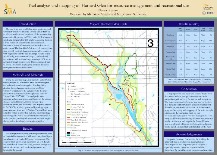
Trail analysis and mapping of Harford Glen for resource management and recreational use Natalie Rymarz Mentored by Mr. Jaime Alvarez and Mr. Kierran Sutherland TM Introduction Map of Harford Glen Trails Results (cont’d) Harford Glen was established as an environmental education center for Harford County Public Schools to educate students and members of the surrounding community. Beginning in 1990, Harford Glen hosted a residential program for fifth graders, engaging them in a wide variety of experimental environmental activities. A series of trails was established to make easier use of Harford Glen’s 340 acres of property. As time passed, the trails became increasingly overgrown with vegetation and the trail markings became faded. Additionally, the current trail map is outdated and inconsistent with trail markings, making it difficult to navigate through the property. This project goal was to create a trail map meeting the needs of resource managers and recreational users. Table 1: Trail attributes (Dist.=Distance; Cond.=Condition; Diff.=Difficulty; Elev.=Elevation Range; Mod=Moderate) Methods and Materials Conclusion Using the existing maps, the trails at Harford Glen were surveyed for familiarity. After determining the inconsistencies and missing directional qualities, detailed data collection was inventoried. Using Trimble®TerraSync™, the database with the trail attributes was constructed and uploaded onto the Trimble®GeoXT™ GPS. The trail paths were recorded as lines, and segmented based on the various changes in trail features, (name, surface type, condition, width, and difficulty). The map was created in ArcGIS® by adding a parks and hydrology layer, roads, contour lines, and GPS data. The trail lines were edited to reflect a smoother path and the symbology was changed to reflect the different trail attributes. A scale, compass, and legend were each included to give the map directional and comparative qualities. The purpose of this study was to construct a map that would include enough information to make navigation quick and easy for novice trail navigators. The map was created to be used as a tool for teachers that travel to Harford Glen to conduct research with their classes, and in the curriculum of the residential program. Surveying and mapping of the trails brought attention to the immediate need for trail reconstruction and better resource management. This study could be replicated using the same methods and used to update the trail map in the future. If more time was allotted, additional trail elements and points would have been recorded and included on the map. Results Acknowledgements The comprehensive map pictured presents the trails as recorded in conjunction with the extrapolated layers found online via Harford County Government. The contour lines are set to an interval of 20 feet. Roads are labeled with names and trails, streams, emergency take-out locations , and outdoor classrooms are labeled in the legend. A special thanks to Dianna Kitt for walking the trails with me, as well as Mrs. Gabriel for her encouragement and help throughout the year. I especially want to thank Mr. Alvarez and Mr. Sutherland for providing their expertise and materials. Map 1: The above map displays the various trails investigated at Harford Glen Park.