Download
1 / 6
100 likes | 245 Vues
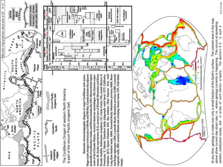
Mercator map projection about pole at 25° N 15 ° E. Rift. USA. USA. USA. S. Oceanic su bd uction complex. 10%/m.y. Island arc assemblage. 1%. now. wUS_Intro.ppt.

E N D
Mercator map projection about pole at 25° N 15 ° E Rift USA USA USA S Oceanic subduction complex 10%/m.y. Island arc assemblage 1% now wUS_Intro.ppt At any time, geology is made over only a small fraction of the Earth’s surface. The colored area in the map above show current-day strain rate, i.e., where geology currently is happening. This occurs at spreading centers, subduction zones, and in areas of continental orogeny. The western U.S. is such a place. The Cordilleran Orogen of western North America is part of the circum-Pacific orogenic belt.
Present The western U.S. Cordilleran Orogen is defined by broad zones of uplift, deformation and magmatism S-wave velocity 100-175 km ±5.0% Surface Velocity Canada 4 km 3 2 1 0 North American Plate Pacific Plate Mexico mm/yr 48 12 Summary > Plate interaction > Grav. PE > Plate weakness 1 1/2 } Inheritance 0 The area of uplift (which is unusually wide in the western U.S.) is where the Farallon slab is thought to have been flat against gPE and resulting stress North America lithosphere during the Laramide orogeny. Currently, the upper mantle is very slow to seismic waves beneath the uplifted area (the mantle is hot or partially molten). Also, the uplifted area has high amounts of gPE (gravitational potential energy), which acts to drive extension. Cordilleran uplift tension compression The area of active deformation (which is unusually wide in the western U.S.) occurs both at the plate margin and where intense magmatism occurred recently (in the Basin and Range). Only the western portion of the high gPE area is extending, which argues that the deforming area is relatively weak. This is consistent with its history of recent, intense magmatism. Interior deformation is mostly extension, whereas near the transform plate margin deformation is dominated by right-lateral shearing. deformation Cordilleran interior Stress field created by combination of gPE and plate interaction. Light gray areas are weak. Velocity of points relative to stable North America. Projection s such that the Pacific plate moves toward the top of the page. Figure to left shows stresses caused by plate interaction alone; figure at top right shows stresses created by gPE alone. Plate interactions Yellow arrows show plate interaction forces
Lund (2008) Precambrian Simplified Geologic Maps. Precambrian (pink and orange in top map) forms stable continental cores . North America (above). Archean craton blocks were assembled at mobile belts; a series of Proterozoic arcs accreted to the south side of the Archean continent. Proterozoic rifts emplaced intrusions (mid-continent rift, 1.1 Ga) and made basins (diagonal dashes below), but it wasn’t until the end of the Precambrian that rifting split away the western continent. The continent margin (west of the gray line at above) formed an Atlantic-type “miogeoclonal’ margin, with a normal sedimentary shelf (see cross section to right).
Paleozoic Dickinson (2006) Main Geologic Events of the Southwest U.S. (for the area shown in the Blakey figure at bottom left) Tectonic Event core complexes Laramide Sevier Nevadan miogeocline sediment ocean crust hingeline post-rift lithosphere Sonoma crust Ancestral Rockies Precambrian lithosphere Antler Rift Rift Blakey (web site) Dickinson (2006) Passive Margin and the Miogeocline Latest Precambrian rifting stretched the margin of North America (the area between the hingeline and the western edge of purple crust in the tilted figure below). Post-rift lithospheric cooling caused subsidence and creation of a passive “Atlantic-type” margin that received a thick accumulation of sediment in the “miogeocline” west of the hingeline. This state of affairs continued through much of the Paleozoic. Cambrian (~510 Ma) paeogeography. The passive margin setting is established. Carbonate rocks, fluvial and shallow marine sandstone and mudstone grade westward into the paleo-Pacific. Deposits were thin on the continental platform east of the hingeline, and thicken rapidly to the west of the hingeline.
Dickinson (2002) and magmatic arc accretion and growth Mesozoic Paleozoic
43 37 21 27 34 43 28 21 Siletzia accretion and the Ignimbrite flareup Challis-trend magmatism 45-55 Ma Cascade Arc ignimbrite flareup. (SMO, Paleogene Post-Laramide Cenozoic Laramide 30-17.5 Ma Southern core complexes Northern core complexes 55-30 Ma Dickinson (2002)