Download
1 / 1
10 likes | 149 Vues
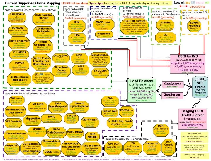
Current Supported Online Mapping 12/19/11 (5 mo. data) Sys output less nagios: > 78,412 requests/day or 1 every 1.1 sec. Legend: app DB spatial oth. DEP iProtect Tim Corcoran, Aaron Richer MapBuilder. Fish DEP, Huaining Zhu Aaron Richer OpenLayers. (4) WIRE DEP, Huaining Zhu

E N D
Current Supported Online Mapping12/19/11 (5 mo. data) Sys output less nagios: > 78,412 requests/day or 1 every 1.1 sec Legend: appDBspatialoth DEP iProtect Tim Corcoran,Aaron Richer MapBuilder Fish DEP, Huaining Zhu Aaron Richer OpenLayers (4) WIRE DEP, Huaining Zhu Aaron Richer OpenLayers .NET UIC DEP, Huaining Zhu Aaron Richer OpenLayers .NET DOT MassTrac Cambridge Systematics Barbara Rizzuti crash mapping Flex + WMS MAPCMRWA Christian Spanring OpenLayers Delphi-TS David Lozzi OpenLayers + Sharepoint USGSNatl Map Calvin Meyer MassAudubon Matthew Smith OpenLayers MVPC Jerrard Whitten Google Maps + WMS Tax Cut Chris Wren Google Maps + WMS Search Well DEP, Huaining Zhu OpenLayers CPA CPC Stuart Saginor, Aleda Freeman MapBuilder geocoding apps on MassGIS servers – to ArcIMS (maps) + ArcIMS (geocoding) apps on non-MassGIS servers – to ArcIMS (maps) + ArcIMS (geocoding) apps on MassGIS maps server – to GeoServer + ArcIMS (geocoding) apps on MassGIS maps server – to GeoServer apps on non-MassGIS servers – to GeoServer + ArcIMS (geocoding) apps on non-MassGIS servers – to ArcIMS (geocoding) CZM MORIS ASA OpenLayers/GeoExt 22 launches/day State Facilities OLIVER ASA OpenLayers/GeoExt • MEMAeCEMP • AppGeo .NET Rob Sousa • 750 users (12) HTML viewers 21e, title5, DEP wetlands, DEP Wetlands Change, DCR snow priority, mema_ecemp, order form, CZM coastguide, WSPA, DCR dams, wind, wind w/ owners Aleda Freeman MHC Michael Steintz (Joshua Rosenthal)Google maps+ WMS EOHHS NewMMIS Geocoding John Kauer CZM MassBays Habitat Atlas ASA Charlton Galvarino OpenLayers/GeoExt EOHED (2) Lowell and SCR Editing Jessica Casey OpenLayers/GeoExt Watershed DEP, Huaining Zhu EOPS SPOLIVER ASA Dan Bibel, Aleda Freeman OpenLayers/GeoExt PriHab Comment Tool DFG Dan Koch OpenLayers/GeoExt In Development 911 Editing Peter Grace OpenLayers/GeoExt MassAudubon Breeding Bird Atlas, Butterfly Atlas OLIVERs (2) ASA OpenLayers/GeoExt MCP DEP Aaron Richer OpenLayers get_xy (utm) DEP Aaron Richer OpenLayers ESRI ArcIMS 23 AXL mapservices output: > 2,001 images/day > 1,482 geocodes/day > 42 queries/day Aleda Freeman (4) HLI, Trails, Forestry, Res. Mgmt. Plan DCR David Kimball OpenLayers OLIVER ASA OpenLayers/GeoExt 275 launches/day WMA DFG Kevin Robicheau OpenLayers Broadband Survey Google Maps Aleda Freeman EJ OLIVER ASA OpenLayers/GeoExt (6) JSPviewers DOR LA3, Census by town or legis, DCR WPA, legis, DCR Acecs Aleda Freeman (2) Boat Ramps, Biomap2DFG Dan Koch, Kevin Robichaeu OpenLayers ESRI SDE Oracle (VWP, IWP) Pergamon MichaelTrust Load Balancer 1,121 layers or tables 1,843 SLD styles output: 74,549 req./day (map, info, extract) from cache: 30% Aleda Freeman GeoServer Aleda Freeman GeoServer Aleda Freeman apps on non-MassGIS servers - to GeoServer OSToolbar Gabriela Laird ArcMap .NET Harvard OpenGeoportal Bonnie Burns OpenLayers Tufts OpenGeoportal Patrick Florance OpenLayers MA Legis Ed Bell Jared Brown,Tallan, Inc. Google VTP Northeast Ocean Data Viewer ASA Flex PB Well DEP, Aaron Richer OpenLayers staging ESRI ArcGIS Server 8 mapservices geocodingIn Development 338 requests/day Gabriela Laird MapsOnline PeopleGIS Joshua Rosenthal N. Midd. Reg. Deeds AppGeo .NET Peter Girard, Dick Howe MIT GeoWeb Lisa Sweeney OpenLayers DCR Gull Tracking Javascript Gabriela Laird (2)DOE Brian Philpot (John Kim) ASP MAPC DataCommon Christian Spanring OpenLayers Town of Amherst Michael Olkin Google Maps + WMS MHC MACRIS Kathryn Catlin Webservices Wiki: https://wiki.state.ma.us/confluence/display/massgis over 82 page views/day apps on MassGIS IIS – to ArcGIS Server DAR Organic Farms Javascript Gabriela Laird ITD VoIP status editing JavascriptGabriela Laird In Development Habitat DB NHESP Javascript Gabriela Laird In Development NERACOOS Map and Model Viewer J. Ru Morrison Eric Bridger GPV DCR AppGeo .NET Gabriela Laird, David Kimball In Development City of Boston 2008 Distressed Private Property Regina Obe OpenLayers nagios real time monitoring, email alerts, stats -- uses 1,440 requests /day V:\MgisProjRes\Projects\Online_Mapping_and_other_Aleda_Stuff\Statisticshttp://maps.massgis.state.ma.us/MassGIS_online_mapping.pptaleda.freeman@state.ma.us, gabriela.laird@state.ma.us, michael.trust@state.ma.us Webservices Google group: 81 members