Download
1 / 23
230 likes | 365 Vues
Please download animations in the file format of your choice (MPG format is recommended because AVI files are much larger than MPG) August 2010 slow-slip event: ftp://ftp.gps.caltech.edu/pub/minson/chpt_Aug_6-10_2010.avi ftp:// ftp.gps.caltech.edu/pub/minson/chpt_Aug_6-10_2010.mpg

E N D
Please download animations in the file format of your choice (MPG format is recommended because AVI files are much larger than MPG) August 2010 slow-slip event: ftp://ftp.gps.caltech.edu/pub/minson/chpt_Aug_6-10_2010.aviftp://ftp.gps.caltech.edu/pub/minson/chpt_Aug_6-10_2010.mpg Full 2010 time series for whole PANGA network:ftp://ftp.gps.caltech.edu/pub/minson/chpt_one_lin_2010.aviftp://ftp.gps.caltech.edu/pub/minson/chpt_one_lin_2010.mpg The Seattle ReportSarah MinsonUSGS Seattle
*Please excuse technical jargon Ongoing Science Stuff*
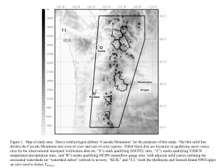
Earthquake monitoring using GPS • Dense real-time 1 Hz GPS network • Utilize GPS with seismic data to identify and analyze events for which GPS data contribute the most • Hazardous earthquakes • Slow slip events
Rapid response rupture models using real-time GPS • Monte Carlo exploration of fault extent, location, and slip • Okada model • Constraints on fault-finiteness depend greatly on source receiver geometry • Moment is well-determined • Need to detect events and estimate offsets in real-time
Bayesian changepoint detection • Changepoint: the time that at least one model parameter changes • Can use Bayes’ theorem to compute the probability of a changepoint as a function of time, P(changepoint=t|D) • Can also use Bayes’ theorem to assess significance of potential changepoints
Bayesian changepoint detection • It may sound fancy, but it’s not • It’s just Bayesian piecewise linear regression • What is P(t=t0)? • The solution is analytical and ridiculously cheap
Annual Nile Discharge The Nile River & The Aswan Dam Probability of Changepoint
Annual Nile Discharge The Nile River & The Aswan Dam Probability of Changepoint 1898 Aswan 1902
Real-time monitoring • That was the retrospectivechangepoint problem • I have a time series. Is there a changepoint or changepoints? If so, when? • For real-time monitoring, need prospectivechangepointanalysis a.k.a. the quickest detection problem • As each new observation arrives, do I now have enough data to identify a changepoint? • Solution is to minimize the Bayes’ risk: • P(false alarm) + c*[average detection delay] • c is tuning parameter
Some complications – or – what we really want are real-time offsets • For slow slip events, we have a functional form for earthquakes • We get offset as part of change-point analysis • For earthquakes, we could get ramps, waveforms, anything • Filter the heck out of the GPS time series until we make it look like a ramp? • Window out the earthquake?
One more thing • If we want to use GPS stations to detect events (to trigger rapid response or for EEW) and/or we want to retrospectively search for deformation events, we have to discriminate between changepoints due to signals and those due to noise • Need to rely on spatio-temporal pattern of stations with possible detections • Could treat triggers at GPS stations like seismic data or could do something new
A little motivation • Need offshore measurements to understand plate locking and ETS, as well as to determininecoseismic slip • Basic science could be done with campaign measurements, but monitoring needs real-time data • Real-time might not be more expensive due to the costs of ship time to retrieve instruments and data • The PBO should extend to the plate boundary • Even better, should go beyond trench to understand deformation of incoming plate
Many kinds of measurements • Mature instrumentation: • GPS-acoustic • Ocean bottom pressure sensors • DART • Seafloor fluid flow • Campaign relative gravity • Japan is deploying 5,100 km of cable to install 154 nodes with OBS/OBP • On the horizon: • Seafloor timelapse gravity (absolute gravity) • Self-calibrating pressure recorders (decreases instrument drift) • Non-electronic seismometer/tiltmeter (decreases instrument drift of tiltmeters) • Seafloor interferometric optical fiber strainmeter
Q. Who pays?A. No clue • When it comes to monitoring, the USGS is the obvious choice • The USGS doesn’t have the money • NOAA might want to expand DART network, install more OBP • FEMA? DHS?
Conference Highlights • Best factoid: • Turbidite flow from Tohoku hit OBP station P03 and moved it about 1 km to the east • Runner-up best factoid: • Largest onshore displacement from Tohoku was 5 m, but largest offshore displacement was 31 m • Best unnecessarily long word: • Seismohydrogeodynamic • Best potential pitfall: • Will the U.S. Navy stand in the way of possible future offshore network to protect secrecy of their submarine positions?