Download
1 / 22
220 likes | 324 Vues
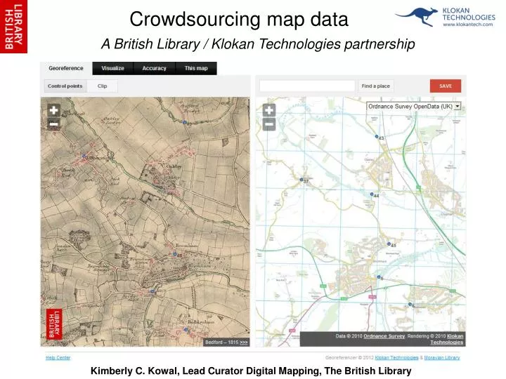
A British Library / Klokan Technologies partnership. Crowdsourcing map data. Kimberly C. Kowal, Lead Curator Digital Mapping, The British Library. Quick Facts. 725 maps assigned spatial metadata 13-18 February 2012 90 participants Publicity minimal – social media *key*

E N D
A British Library / Klokan Technologies partnership Crowdsourcing map data Kimberly C. Kowal, Lead Curator Digital Mapping, The British Library
Quick Facts • 725 maps assigned spatial metadata • 13-18 February 2012 • 90 participants • Publicity minimal – social media *key* • Top five participants completed half the work • Data quality good: <3% had errors >.005
What is georeferencing? Ordnance Surveyors Drawing 40(detail). British Library, Maps OSD 40(3).
Ordnance Survey drawings Original large-scale drawings made for the famous one-inch-to-the-mile maps. England and Wales, 1780-1840. Part of Staffordshire Containing 100 Square Miles Surveyed by Mr Field and Drawn by Mr Stevens (detail). Pen and ink on paper. 1817. British Library shelfmark: OSD 210. Crace Collection of maps of London Illustrating development of the city and its immediate vicinity from ca 1570 - 1860 BAYNARDS CASTLE AND FARINGDON WARD WITHIN with their Divisions into Parishes according to a new SURVEY. (detail). Cole, B. engraver. 1754. British Library shelfmark:Maps Crace VIII.25
Remaining… • Correcting errors • Data management • Engaging participants: thanking / feedback • Preparations for next lot of maps – within the next month! • Continued improvements to application
What made it work… Content relevant Accessibility and convenience of application paramount Activity engaging Immediate results and feedback Competitive crowdsourcing tools Recognition and visible overall contribution