Download
1 / 19
190 likes | 311 Vues
Vulnerability and adaptation of coastal fisheries to climate change. Scientific support for the management of Coastal and Oceanic Fisheries in the Pacific Islands region ( SciCOFish ). Funded by European Union (10 th EDF). Sensor Web Enablement for the Pacific. Climate change monitoring.

E N D
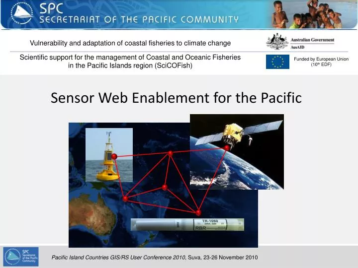
Vulnerability and adaptation of coastal fisheries to climate change Scientific support for the management of Coastal and Oceanic Fisheries in the Pacific Islands region (SciCOFish) Funded by European Union (10th EDF) Sensor Web Enablement for the Pacific
Climate change monitoring • Climate change monitoring involves long-term datasets from numerous partners and observation data must be made available • Need for a system to share sensor observations • Climate change trends are slow compared to interannual or interdecadal climate variability.The trends can be biased by sensors & process: • Sensor accuracy • Change in methodology/sensor/location • Need for rigorous metadata about sensors, processes and observations
Open Geospatial Consortium Standards • Web Map Service (WMS) • Requests for geo-referenced map images • 1999: WMS 1.0.0 • 2004: WMS 1.3.0 • Web Feature Service (WFS) • Requests for geographical features (vector data in GML) • 2002: WFS 1.0.0 • 2009: WFS 2.0.0 • Web Coverage Service (WCS) • Requests for geographical coverages (raster data in GeoTIFF) • 2003: WCS 1.0.0 • 2009: WCS 2.0.0 • Some implementations of these services • ArcGIS Server, GeomediaWebMap, MapXtreme, Geoserver, MapServer,… • (seehttp://www.opengeospatial.org/resource/products/compliant for full list)
Open Geospatial Consortium Standards • OGC Sensor Web Enablement (SWE) Standards • Standards to exploit web connected sensors and sensor data. 1.0.0 version released in 2006-2007. • Information models • Observation & Measurement Schema (O&M) • Encoding of observations and measurements • Sensor Model Language (SensorML) • Describes sensor systems and processes • Transducer Markup Language (TransducerML) • Describes transducers (response model) • Web services • Sensor Observation Service (SOS) • Provides access to observations • Sensor Planning Service (SPS) • Tasks acquisition from sensors • Sensor Alert Service (SAS) • Subscribe to specific alert type • Web Notification Service (WNS) • Asynchronous communication for long requests
Observation & Measurement Schema • “An observation is an event that estimates an observed property of a feature of interest using a procedure and generating result.” • Feature of interest • Domain specific feature, which is a representation of the observation target for which the observation is made. • Earth realm (ocean, river, sea surface,...) • Named region, location (Micronesia, Kimbe Bay) • Event (cyclone Erica) • System (sensor) • Observed property • Phenomenon for which the observation result provides an estimate of its value. • Temperature • Humidity • Procedure • Description of a process used to generate the result (sensor, model, observer) • Result • Value generated by the procedure • Additionalproperties • Sampling Time, Result Time, Parameter, Metadata, ResultQuality
Observation & Measurement Schema • “An observation is an event that estimates an observed property of a feature of interest using a procedure and generating result.” • <om:Measurement> • <om:samplingTime><gml:TimeInstant> • <gml:timePosition>2010-10-14T00:22:12+11:00</gml:timePosition> • </gml:TimeInstant> </om:samplingTime> • <om:featureOfInterest> • <sa:SamplingPoint> • <gml:name>Weather station of Zsyxx</gml:name> • <sa:sampledFeature xlink:href="myFeatureReference"/> <sa:position> <gml:Point srsName="EPSG:4326"> • <gml:pos>160.124 -22.14</gml:pos> • </gml:Point> </sa:position> • </sa:SamplingPoint> • </om:featureOfInterest> • <om:observedProperty xlink:href="property:OGC:RelativeHumidity"/> • <om:procedure xlink:href="mySensorReference"/> • <om:result xlink:href="percent" >41</om:result> • </om:Measurement> When Where What How Value
SensorML/TransducerML • There are many ways of measuring a single physical value ! °C °F K
SensorML/TransducerML • SensorML is used to define physical (detectors,...) and non-physical (classification, image processing, spatial transforms,...) processes • Description • Parameters • Metadata • General information (identifier and classifier) • Constraints (valid time, legal constraints) • Properties (capabilities and characteristics) • References (contacts and documentation) • History • Inputs (observed phenomena or incoming data for a non-physical process) • Outputs (data created by the process)
SensorML examples • Example: Garmin GPS 17 HVS <?<sml:SensorML <!-- Derived from Garmin Spec sheet --> <sml:member> <sml:Systemgml:id="GPS_17HVS"> <gml:description>SensorML instance for a Garmin GPS</gml:description> <gml:name>Garmin GPS 17HVS</gml:name> <sml:identification> <sml:IdentifierList<><sml:identifier> <sml:Term definition="urn:x-ogc:def:identifier:OGC:shortName“> <sml:value>Garmin 17HVS</sml:value></sml:Term></sml:identifier></sml:IdentifierList> </sml:identification> <sml:classification> <sml:ClassifierList><sml:classifier name="Sensor Type"> <sml:Term definition="urn:x-ogc:def:classifier:OGC:sensorType"> <sml:value>GPS</sml:value> </sml:Term> </sml:classifier></sml:ClassifierList> </sml:classification> <sml:characteristics> <swe:Record> <swe:field name="channels"> <swe:Count> <swe:value>12</swe:value> </swe:Count> </swe:field> </swe:Record> </sml:characteristics> Description Identifier Classification Characteristics
SensorML examples • Some outputs of the GPS sensor <sml:outputs> <sml:OutputList> <sml:output name="Record1_output"> <swe:Record id="record_type_1"> <swe:field name="position“><swe:Position id="GPS_POSITION"> <swe:location><swe:VectorreferenceFrame="urn:x-ogc:def:crs:EPSG:6.1:4329"> <swe:coordinate name="latitude“> <swe:Quantity><swe:uom code="deg"/></swe:Quantity> </swe:coordinate > <swe:coordinate name="longitude"> <swe:Quantity><swe:uom code="deg"/></swe:Quantity> </swe:coordinate > </swe:Vector> </swe:location> </swe:Position> </swe:field> <swe:field name="samples"> <swe:Count definition="urn:ogc:def:data:numOfSamples"/> </swe:field> <swe:field name="operationTime"> <swe:Quantity definition="urn:ogc:def:sensor:MMI:timeSinceStartup"> <swe:uom code="s"/></swe:Quantity> </swe:field> </swe:Record> </sml:output> </sml:OutputList></sml:outputs> </sml:System></sml:member></sml:SensorML> Position Number of samples Operation time
SensorML examples • System capabilities of a Conductivity, Temperature, Depth (CTD) Sensor <sml:capabilities> <swe:Record> <swe:field name="Depth Capability"> <swe:Quantity definition="urn:x-ogc:def:classifier:SBE:depthCapability"> <swe:uom code="m"/> <swe:value>7000</swe:value> </swe:Quantity> </swe:field> <swe:field name="Storage Type"> <swe:Category definition="urn:x-ogc:def:classifier:SBE:storageType"> <swe:value>EEPROM</swe:value> </swe:Category> </swe:field> <swe:field name="Memory Capacity"> <swe:Count definition="urn:x-ogc:def:classifier:SBE:memoryCapacity"> <swe:uom code="By"/> <swe:value>2960000</swe:value> </swe:Count> </swe:field> </swe:Record> </sml:capabilities>
SensorML examples • System inputs of a Conductivity, Temperature, Depth (CTD) Sensor <sml:inputs> <sml:InputList> <sml:input name="temperature"> <swe:Quantity definition="urn:x-ogc:def:phenomenon:OGC:temperature"> <swe:description>Sea Water Temperature</swe:description> </swe:Quantity> </sml:input> <sml:input name="conductivity"> <swe:Quantity definition="urn:x-ogc:def:phenomenon:OGC:conductivity"> <swe:description>Sea Water Conductivity</swe:description> </swe:Quantity> </sml:input> <sml:input name="pressure"> <swe:Quantity definition="urn:x-ogc:def:phenomenon:OGC:pressure"> <swe:description>Sea Water Pressure</swe:description> </swe:Quantity> </sml:input> </sml:InputList> </sml:inputs>
SensorML examples • System outputs of a Conductivity, Temperature, Depth (CTD) Sensor <sml:output name="output data"> <swe:Record id="CDT_DATA"> <swe:field name="temperature"> <swe:Quantity definition="urn:x-ogc:def:phenomenon:OGC:temperature"> <swe:description>Sea Water Temperature</swe:description> <swe:uom code="Cel"/> <!-- UCUM code for degC --> <swe:constraint><swe:AllowedValues><swe:interval>-10.0 100.0</swe:interval></swe:AllowedValues> </swe:constraint> <swe:quality><swe:Accuracy><swe:uom code="Cel"/><swe:value>0.002</swe:value></swe:Accuracy> </swe:quality> </swe:Quantity> </swe:field> <swe:field name="conductivity"> <swe:Quantity definition="urn:x-ogc:def:phenomenon:OGC:conductivity"> <swe:description>Sea Water Conductivity</swe:description> <swe:uom code="S/m"/> <swe:constraint><swe:AllowedValues><swe:interval>0 10.0</swe:interval></swe:AllowedValues> </swe:constraint> <swe:quality><swe:Accuracy><swe:uom code="S/m"/><swe:value>0.0003</swe:value></swe:Accuracy> </swe:quality> </swe:Quantity> </swe:field>
Sensor Observation Service 1.0 Obtention of sensor description and observations through SOS GetCapabilities() CapabilitiesResponse DescribeSensor() SensorML/TML GetObservation() O&M Data SOS Client SOS Server
Sensor Observation Service 2.0 SOS 2.0 (RFC at the moment) extends SOS 1.0 GetObservationByID GetFeatureOfInterest InsertSensor DeleteSensor InsertObservation InsertResult InsertResultTemplate GetResultTemplate GetResult SOS Client SOS Server
Sensor Web Enablement for climate change data • Climate change monitoring constraints: • Need for a system to share sensor observations • Need for rigorous metadata about sensors, processes and observations • O&M schema provides a standard for observations • SensorML provides a standard for sensors and processes metadata • SOS provides a mechanism to access that information SWE
Vulnerability and adaptation of coastal fisheries to climate change • SPC is deploying temperature scientific-grade sensors in some pilot sites for long term monitoring of sea surface temperature in reef areas. • The data will be made freely available on SPC web site through Sensor Observation Service in 2011.
Some existing Sensor Observation Service servers • NOAA Integrated Ocean Observing System (IOOS) • http://sdf.ndbc.noaa.gov/sos/ • http://opendap.co-ops.nos.noaa.gov/ioos-dif-sos/ • Institute for Geoinformatics University of Münster weather data • http://v-swe.uni-muenster.de/ • Renaissance Computing Institute (RENCI) Sensor Data Bus • http://www.sensordatabus.org/default.aspx
Sensor Web Enablement resources • OGC Sensor Web Enablement working group • http://www.opengeospatial.org/projects/groups/sensorweb • OGC SWE Standards • http://www.opengeospatial.org/standards/om • http://www.opengeospatial.org/standards/sensorml • http://www.opengeospatial.org/standards/sos • Implementing Sensor Observation Service • http://mapserver.org/ogc/sos_server.html • http://www.oostethys.org/downloads • http://52north.org/ • http://wiki.deegree.org/deegreeWiki/deegree3/SensorObservationService • http://ogc.codeplex.com/