Download
1 / 3
40 likes | 240 Vues
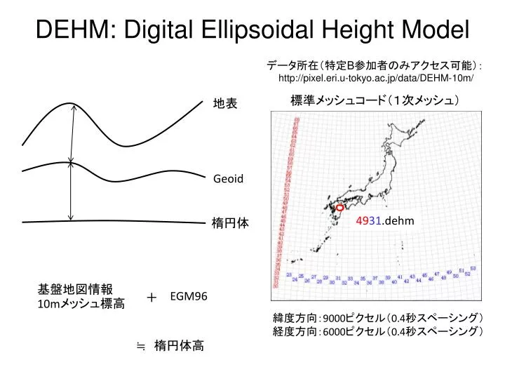
DEHM: Digital Ellipsoidal Height Model. データ所在(特定 B 参加者のみアクセス可能): http ://pixel.eri.u-tokyo.ac.jp/data/DEHM-10m/. 標準メッシュコード(1次メッシュ). 地表. Geoid. 49 31 .dehm. 楕円体. 基盤地図情報 10m メッシュ標高. EGM96. +. 緯度方向: 9000 ピクセル( 0.4 秒 スペーシング ) 経度方向: 6000 ピクセル( 0.4 秒スペーシング). ≒ 楕円体高. timing.dorisin に入力する座標.

E N D
DEHM: Digital Ellipsoidal Height Model データ所在(特定B参加者のみアクセス可能): http://pixel.eri.u-tokyo.ac.jp/data/DEHM-10m/ 標準メッシュコード(1次メッシュ) 地表 Geoid 4931.dehm 楕円体 基盤地図情報10mメッシュ標高 EGM96 + 緯度方向:9000ピクセル(0.4秒スペーシング) 経度方向:6000ピクセル(0.4秒スペーシング) ≒ 楕円体高
timing.dorisinに入力する座標 画像の左上角の座標 yyxx.dehm 経度:xx+100度 (4931.dehmの場合は131度) 緯度:(yy+1)÷1.5 (4931.dehmの場合は33度20分) 画像の左上ピクセルの中心の座標 (timing.dorisinに入力すべき値) 経度:画像の左上角の経度+0.2秒 緯度:画像の左上角の緯度-0.2秒
ファイルの結合 緯度方向: 経度方向: 4931.dehm 4932.dehm 4931.dehm 4831.dehm REAL*4 BUF1(9000),BUF2(9000) INTEGER IX,IY OPEN(10,FILE=‘4931.dehm’,ACCESS=‘DIRECT’,RECL=4*9000) OPEN(11,FILE=‘4932.dehm’,ACCESS=‘DIRECT’,RECL=4*9000) OPEN(12,FILE=‘join.dehm’,ACCESS=‘DIRECT’,RECL=4*9000) DO IY=1,6000 READ(10,REC=IY) BUF1 READ(11,REC=IY) BUF2 WRITE(12,REC=2*IY-1) BUF1 WRITE(12,REC=2*IY ) BUF2 ENDDO CLOSE(10) CLOSE(11) CLOSE(12) STOP END (注:アポストロフィーが全角になっているため,コピペでは動きません) cat 4831.dehm >> 4931.dehm