Download
1 / 2
20 likes | 175 Vues
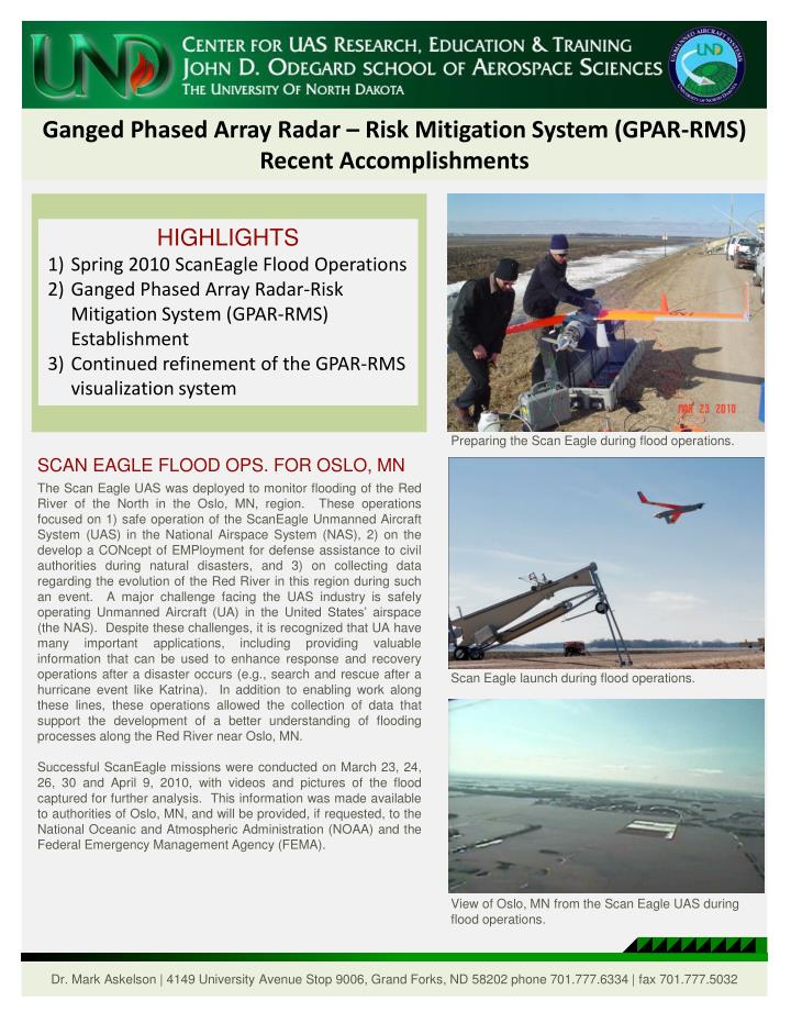
Ganged Phased Array Radar – Risk Mitigation System (GPAR-RMS) Recent Accomplishments. HIGHLIGHTS Spring 2010 ScanEagle Flood Operations Ganged Phased Array Radar-Risk Mitigation System (GPAR-RMS) Establishment Continued refinement of the GPAR-RMS visualization system.

E N D
Ganged Phased Array Radar – Risk Mitigation System (GPAR-RMS) Recent Accomplishments • HIGHLIGHTS • Spring 2010 ScanEagle Flood Operations • Ganged Phased Array Radar-Risk Mitigation System (GPAR-RMS) Establishment • Continued refinement of the GPAR-RMS visualization system Preparing the Scan Eagle during flood operations. SCAN EAGLE FLOOD OPS. FOR OSLO, MN The Scan Eagle UAS was deployed to monitor flooding of the Red River of the North in the Oslo, MN, region. These operations focused on 1) safe operation of the ScanEagle Unmanned Aircraft System (UAS) in the National Airspace System (NAS), 2) on the develop a CONcept of EMPloyment for defense assistance to civil authorities during natural disasters, and 3) on collecting data regarding the evolution of the Red River in this region during such an event. A major challenge facing the UAS industry is safely operating Unmanned Aircraft (UA) in the United States’ airspace (the NAS). Despite these challenges, it is recognized that UA have many important applications, including providing valuable information that can be used to enhance response and recovery operations after a disaster occurs (e.g., search and rescue after a hurricane event like Katrina). In addition to enabling work along these lines, these operations allowed the collection of data that support the development of a better understanding of flooding processes along the Red River near Oslo, MN. Successful ScanEagle missions were conducted on March 23, 24, 26, 30 and April 9, 2010, with videos and pictures of the flood captured for further analysis. This information was made available to authorities of Oslo, MN, and will be provided, if requested, to the National Oceanic and Atmospheric Administration (NOAA) and the Federal Emergency Management Agency (FEMA). Scan Eagle launch during flood operations. View of Oslo, MN from the Scan Eagle UAS during flood operations. Dr. Mark Askelson | 4149 University Avenue Stop 9006, Grand Forks, ND 58202 phone 701.777.6334 | fax 701.777.5032
Ganged Phased Array Radar – Risk Mitigation System (GPAR-RMS) Recent Accomplishments GPAR-RMS ESTABLISHMENT The number one challenge that limits Unmanned Aircraft (UA) operations in the United States’ airspace [the National Airspace System (NAS)] is the lack of a person onboard the aircraft to perform the “see and avoid” function required by the regulations that govern NAS use. “See and Avoid” simply means watching for other aircraft and avoiding colliding with them. Personnel within the Center for Research, Education, and Training at the University of North Dakota have been pursuing a two-pronged approach to meeting this challenge. These involve sensing aircraft using ground-based radars and providing the required information to UA pilots [the Ganged Phased Array Radar-Risk Mitigation System (GPAR-RMS)] and the use of sensors onboard UA to identify and avoid other aircraft [Airborne Sense and Avoid (ABSAA)]. For the GPAR-RMS, a plan for utilizing such a system has been developed, with system establishment and testing ongoing. A 40 ft fifth-wheel trailer was acquired to be the operations center for both the GPAR-RMS and the Scan Eagle GCS. The Scan Eagle GCS has already been fully integrated into the Operations Trailer. Modification of this trailer for use in the GPAR-RMS is nearing completion, with integration of the required computer infrastructure underway. Software will be ported to these computers to offer support for the prototype GPAR-RMS visualization system. GPAR-RMS VISUALIZATION The visualization prototype developed for the Ganged Phased Array Radar-Risk Mitigation System (GPAR-RMS) (described briefly above) contains two displays: 1) the Range Control Center Information Display System (RCCIDS) and 2) the Ground Observer Information Display System (GOIDS). Both displays are undergoing minor modifications to improve their effectiveness as dictated by human factors principles. The RCCIDS will be monitored by an individual who is responsible for the overall safety of all operations in the monitored area. The GOIDS will be monitored by the personnel acting as the ground observer for the UAS operations. This individual monitors the display and communicates information regarding possible conflicts to a UA operator to enable the safe separation of that UA from other aircraft. These visualization systems utilize multiple types of data, including radar, Global Positioning System (GPS), and Automatic Dependent Surveillance-Broadcast (ADS-B) data, that are fused into a common air picture to be displayed. This system is currently being integrated into the GPAR-RMS Operations Trailer. GPAR-RMS Operations Center and Scan Eagle Ground Control Station (GCS). GPAR-RMS Range Control Center Information Display System (RCCIDS). GPAR-RMS Ground Observer Information Display System (GOIDS).